
A day after RDU weather station sets heat records, ‘excessive heat’ again in forecast
The National Weather Service has issued an “excessive heat warning” for 11 a.m. to 8 p.m. Saturday in much of North Carolina, one day after Raleigh hit the highest temperature and heat index in recorded history.
The high temperature Saturday is expected to be about 98, but the heat index — the “feels like” temperature that reflects both temperature and humidity — may be 110 degrees or higher, NWS said in its Saturday morning forecast.
Temperatures that extreme could bring significant increases in heat-related illnesses, NWS said, and it point out that with overnight low temperatures in the upper 70s, there has been “little to no overnight relief.”
Thunderstorms, some possible severe, are also in the forecast for Saturday and Sunday, mostly in the evening hours.
The weather service is not calling for another day of record heat, though, following a day that shattered records.
At 1:37 p.m. Friday, the weather station at Raleigh-Durham International Airport recorded an air temperature of 106 degrees Fahrenheit, according to the National Weather Service. That’s the highest temperature at RDU since the station began recording in 1945.
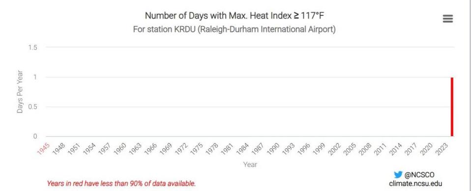
The weather station at Raleigh-Durham International Airport also set an all-time record for heat index on Friday, meaning it has not felt hotter there since the station started recording data.
At 2 p.m., the airport recorded a heat index of 117.8 degrees Fahrenheit. Heat index is a measurement that mixes relative humidity and air temperature to determine what conditions will feel like to the human body.
The previous all-time high heat index for the station was 115 .1 degrees, set on Aug. 15, 2023, according to the Southeast Regional Climate Center.
RDU’s previous all-time temperature record before was 105 degrees, which had been reached six times. The last time RDU was that hot was July 8, 2012, according to the Southeast Regional Climate Center.
On X, the social media platform formerly known as Twitter, the NWS Raleigh office posted that a technician was on-site at the weather station when the record was set and confirmed the reading with “a hand-held calibration device.” A weather observer noted similar readings on two other devices, the NWS account wrote.
Climate change is “very likely” to increase heat index values because of increasing humidity and “likely” to increase the number of hot and very hot days, the N.C. Climate Science report found.
The report also found it very likely that the number of warm and very warm nights, defined as low temperatures that do not dip below 70 and 75 degrees, are likely to increase. Overnight temperatures Wednesday into Thursday and Thursday into Friday both remained above 75 degrees, higher than the average lows of 70 degrees for both days.
After reaching the record highs Friday, the station quickly saw both the temperature and heat index fall.
At 3 p.m., the temperature was 102.9 and the heat index was 110.7 degrees. By 4 p.m., the temperature had dipped to 95 and the heat index to 103.8 degrees.
July 5’s average high temperature is 90.8 degrees at the station, according to the National Weather Service. The previous daily high was 102 degrees, set in 1999.
RDU has reached a temperature at least 104 degrees on 14 other occasions since records started being kept there in 1945.
The first time the weather station reached that threshold was in 1952, when it happened twice. The most recent time before Friday was in 2012, when it happened three times, according to data from the N.C. State Climate Office.
Friday was the second day in a row that temperatures at RDU tied or broke daily records.
Thursday’s 101 degrees tied a record that had been set in 2012, The News & Observer previously reported.
Other weather stations in the Triangle also saw high temperatures and heat indexes at 2 p.m., but not quite as hot as the one at RDU. A station at the North Durham Water Reclamation Facility recorded a temperature of 98.2 degrees and a heat index of 108.2 degrees, while one at the Lake Wheeler Road Field Laboratory in Southwest Raleigh recorded a 95.4 degree temperature and 107.8 degree heat index.
This story was produced with financial support from the Hartfield Foundation and Green South Foundation, in partnership with Journalism Funding Partners, as part of an independent journalism fellowship program. The N&O maintains full editorial control of the work. If you would like to help support local journalism, please consider signing up for a digital subscription, which you can do here.

