
A Rare Derecho Storm Ripped Through the Midwest, Leaving Devastating Damage Behind
An intense derecho storm ripped through Midwestern states Monday, taking down trees and turning over cars with powerful 122 mph winds.
A derecho is rare, but typically occurs during the summer months and presents a unique straight-lined destruction.
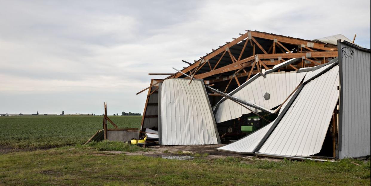
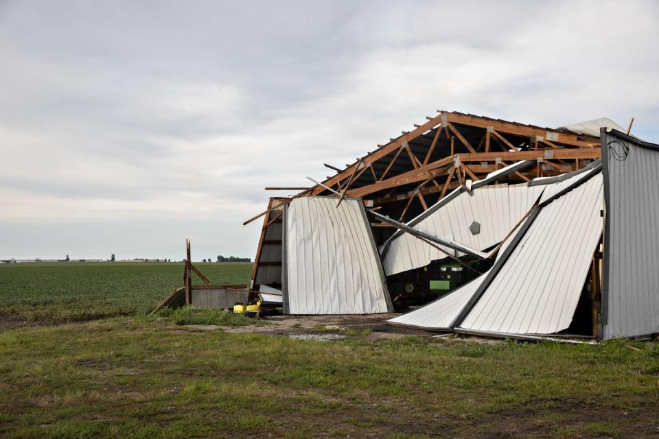
The storm left more than 1 millions homes and business without power.
An unusually powerful storm ripped through several Midwestern states on Monday. While the area is accustomed to some unruly weather, this was no tornado.
This particular storm, known as a derecho, blasted its way past state lines from South Dakota to Iowa, Illinois, and parts of Ohio. It arrived in one long-lasting swoop and carried a mixture of heavy downpour and fierce winds that topped an intense 112 miles per hour, leaving more than 1 millions homes and business without power, per The Weather Channel.
The damage left behind highlights its force, with rows of destroyed homes, damaged building, toppled trees, and flattened crops. Even major cities, including the Chicago area, were impacted by the severity of the storm.
What is a derecho and what does it look like?
These rare storms can take form in the summertime when there is a combination of heat and humidity looming in the air, producing widespread rain coupled with powerful winds, according to the National Weather Service (NWS).
While a derecho can produce destruction similar to a tornado (or even a hurricane), the NWS says that the storm will only show damage sweeping from one direction in a straight path, hence why crops could be seen folded and flatted to one side. This kind of impact has been coined as a “straight-line wind damage.”
Roofing blown off building in Chicago as damaging derecho moves through the region. https://t.co/KjSp7OwIGR pic.twitter.com/XOwSYVXfqo
— ABC News (@ABC) August 11, 2020
Trees down in Hinsdale as wickedly strong storms pushed through the area at 3:45pm. @WGNNews pic.twitter.com/jyoeywX0P8
— Ben Bradley (@BenBradleyTV) August 10, 2020
So what do they look like when they form in the sky? A derecho is linked to a group of thunderstorms that form bow echos, which come together with strong winds and spread in a horizontal direction. With the ebb and flow of cool and warm air, the clouds can become more widespread and take on a gust front with bands of low clouds that look like thin, overlapping rolls in the sky. These dark, looming clouds are classified as an arcus, and can be a terrifying sight to see.
To be classified as a derecho, the storm should have wind gusts of at least 58 mph throughout most of its length, while also dishing out separated gusts of wind at 75 mph, and create damage that trails more than 250 miles, according to the National Oceanic and Atmospheric Administration.
The last 12 hours were intense! As #GOESEast tracked the weather across North America, we could see the severe Midwestern thunderstorms (along with #lightning) that caused a damaging #derecho. Tropical Storm #Elida also strengthened into a #hurricane off the west coast of Mexico. pic.twitter.com/PhERjv4vIv
— NOAA Satellites (@NOAASatellites) August 11, 2020
How often does a derecho occur?
Midwest and southern plains states are most susceptible to a storm of this magnitude from April through August, but they aren’t very common. Depending on the area, a derecho has the potential to form once a year to once every four years, per the NWS. While it is hard to predict the next event, 70% of derechos occur during the warmer seasons.
Really, all you need is favorable weather conditions for the derecho to form. This calls for both hot and humid air mixed with dangerously strong winds.
Hi Chuck, I wanted to come back to this to point out this map that shows derecho climatology across the United States. They are relatively rare this far south in TX but not unheard of. pic.twitter.com/BfohjQjzNe
— NWS Austin/San Antonio (@NWSSanAntonio) August 11, 2020
Support from readers like you helps us do our best work. Go here to subscribe to Prevention and get 12 FREE gifts. And sign up for our FREE newsletter here for daily health, nutrition, and fitness advice.
You Might Also Like

