
Heat warnings issued as scorching long weekend looms
Heat warnings have been issued for Ottawa and other parts of eastern Ontario as an "atypical" wave of hot air blankets the region.
Daytime highs will hover around 30 C on Sunday and stay that way for several days, Environment Canada said in an alert issued Saturday afternoon.
The humidity, however, could make it feel more like 35 C to 40 C.
"Despite overnight temperatures being lower than warning criteria in some areas, humidex and daytime highs will be very atypical of early September," the weather agency said.
People should drink plenty of water during the hot spell, while outdoor workers should take plenty of breaks, Environment Canada said.
Heat illness symptoms include swelling, rashes, cramps, fainting, heat exhaustion, heat stroke, and the worsening of pre-existing conditions. Children, pregnant adults and older people are among those who are more vulnerable, the agency said.
As of Saturday afternoon, the warnings also covered eastern Ontario communities like Brockville, Clarence-Rockland, Cornwall, Gananoque and Kingston.
An arriving cold front will bring an end to the heat on Wednesday, Environment Canada said.
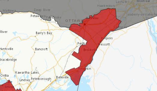
This map shows the areas in eastern Ontario that were covered by heat warnings as of Saturday afternoon. (Environment Canada)
Comes after cool August
The long weekend heat wave comes after a relatively temperate August.
The temperature didn't reach 30 C once last month, something that hasn't happened in August since 2008.
Environment Canada's forecast calls for a high of 31 C on Sunday, and 32 C on Monday, Tuesday and Wednesday.
A 'Goldilocks' summer
There have only been five days with temperatures above 30 C since the first day of summer on June 21.
"I'd call it a Goldilocks summer. Not too hot, not too cold," said Peter Kimbell, a meteorologist with Environment Canada.
The warmest day in August was Aug. 9, when the temperature hit 28.3 C. The last time the temperature topped 30 C was on July 11, with a high of 31.6 C.
Rainfall was also above average in August, with 110.8 millimetres of rain, compared to a normal of 86 millimetres.
We also had more rainy days than average.
"It was unusual, but we'll make up for it very soon," Kimbell said.

