
Severe storm threat completes hot, dry stretch across Ontario, Quebec
Visit The Weather Network's wildfire hub to keep up with the latest on the active start to wildfire season across Canada.
A building thunderstorm risk for parts of southern Ontario and Quebec will finish off what was an early stretch of summer-like heat and dry weather across the region. Multiple days of 30°C were recorded in southern communities this week, and this will help to fuel the incoming storm risk for the end of the work week.
A thunderstorm threat will blanket much of Ontario and Quebec as the day progresses on Friday, with some of the storms potentially growing severe in parts of both provinces. This will also help to wash out the hot and humid airmass as we head into the weekend.
Friday
Areas: Northwestern, central, and eastern Ontario, as well as parts of southwestern Quebec
Weather: Forecasters expect thunderstorms to develop in the heat of the day on Friday, beginning in the early to mid-afternoon hours and persisting through the early evening.

While the storms near Lake Superior will likely stay non-severe in nature, conditions are favourable for more numerous and more powerful thunderstorms toward eastern Ontario.
The dynamics in place Friday will support stronger storm development across parts of cottage country and eastern Ontario, including the Ottawa Valley and toward Montreal.
Strong wind gusts and some hail are possible in the strongest storms. There’s enough moisture that some of the storms could produce heavy to torrential rainfall.
There’s a low risk that a storm or two may track south out of cottage country toward the far-eastern and northern extent of the Greater Toronto Area, so it might be wise to grab the umbrella just in case.
This Weekend
Fresher weather will start to return to Ontario and Quebec as the ridge responsible for the warmth starts to weaken and a trough builds in its place.
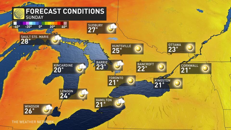
Ample sunshine will stick around through Saturday and Sunday for most of the region, with temperatures returning closer to seasonal for the beginning of June. Enjoy it while it lasts, however, as some wet weather and even below-seasonal temperatures will creep back into the forecast by early next week.
Prepare
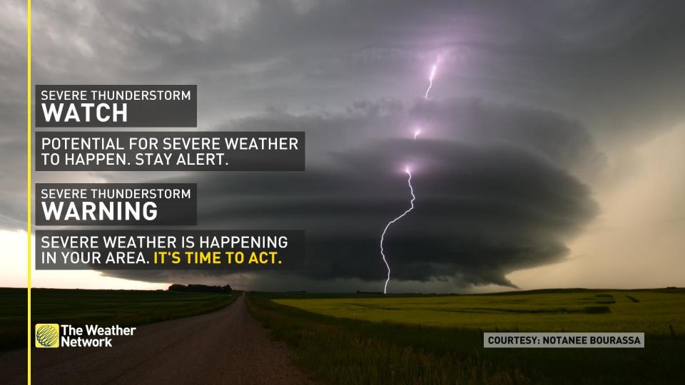
Stay alert and monitor the forecast for updates. Have a plan and a place to head indoors if the weather changes.
Watches mean conditions are favourable for the development of severe thunderstorms.
Warnings mean they are imminent or occurring in your area.
Stay tuned to The Weather Network for more forecast updates in Ontario and Quebec.
Thumbnail image courtesy: Mark Robinson

