
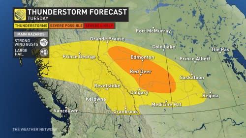
Severe storms to bring large hail and strong winds to parts of Alberta
An active and unsettled pattern will take hold of much of the Prairies this week, with a risk for severe thunderstorms targeting parts of Alberta on Tuesday. Large, and potentially damaging hail, and strong wind gusts are the main threats with Tuesday's storms.
While there is the likelihood for supercell thunderstorms to develop, the tornadic risk remains low.

Regardless, it will be important to stay on top of the weather watches and warnings in your area, as conditions can change quickly when severe weather hits.
SEE ALSO: Watch? Warning? How we communicate severe weather in Canada
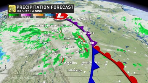
Rounds of rain will continue through the end of this week, though it looks as if southern Alberta and southwestern Saskatchewan will miss out on most of the heavier rainfall amounts. There's a higher potential for beneficial rain next week as the active pattern continues.
Tuesday: Thunderstorms threaten large hail and strong winds
Thunderstorms will initiate off the foothills by mid-afternoon on Tuesday, and track northeastward into the early evening hours.
A line of storms is likely to cross the QE2 from Calgary to Edmonton by the late afternoon, and continue eastward to the Saskatchewan border through the evening. There could be a second round of storms developing west of Calgary through the evening hours, while scattered storms along Highway 16, west of Edmonton, will continue.
Strong winds and the threat for large hail are on the table, both of which have the risk to be damaging.
RELATED: Drought over for parts of the Prairies following May showers
Supercell thunderstorms are likely to develop, but the tornadic risk is low.

Beyond Tuesday's storms, a risk for rain will continue through much of this week, though southern sections are likely to miss out. More beneficial, widespread rain will cover the region through next week.
A wide range in temperatures are expected through the weekend, with cooler than seasonal conditions dominating most areas, while parts of southern Alberta and Saskatchewan are likely to see some hot weather on Friday.
At this point, it looks like a rather chilly and wet Father’s Day across southern and central Alberta and into parts of Saskatchewan.
WATCH: May showers bust drought for parts of the Prairies
Be sure to check back for the latest weather updates across Alberta.

