
Final May days see plenty of rain and storm risks in southern Ontario
A well-deserved break for southern Ontario during the day Sunday as the storm risk slumps south, allowing the soils and ground to dry out after rounds of storms crossed many regions over the past several days.
It will be a good day for a round of golf, a hike or walk, yard work or other outdoor activities with abundant sunshine and warm temperatures still in place across the region.
DON’T MISS: Ominous signs for hurricane season as Atlantic swelters, La Niña looms
That will all change come Sunday night when a potent stateside low-pressure system moves into parts of southern Ontario, bringing rain and a thunderstorm risk –– marking the start of a cooler, more unsettled pattern as we head into the final days of May.
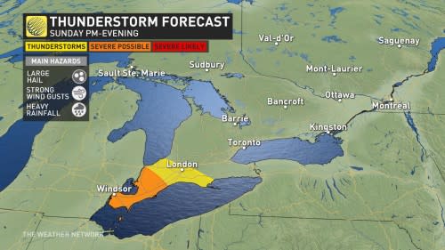
Storms possible Sunday night into Monday morning
A classic Colorado low spawning ample severe weather south of the border this weekend will move into the Great Lakes region through the latter half of Sunday.

Several rounds of rain and thunderstorms will sweep into southern Ontario on Sunday night as this low-pressure system draws closer to the region.
The first wave of rain will push over southwestern Ontario Sunday evening, and will include a chance of thunderstorms. Parts of the region, including the Windsor and Sarnia areas, could see severe storms, with the threat of large hail (nickel-sized or greater), heavy downpours and strong wind gusts.
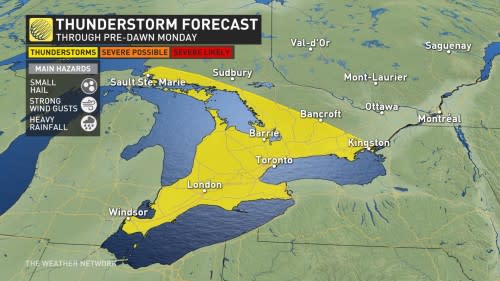
A second push of rain and storms will move into the region through the pre-dawn hours on Monday. Thunderstorms could reach farther north than they did overnight, with thunder possible around Toronto and Hamilton as the Monday morning commute begins.
While neither of the nighttime rounds of storms are expected to be severe, any stronger cells could produce small hail, gusty winds, and heavy rainfall.
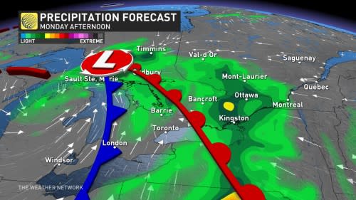
Renewed storm risk bubble Monday afternoon
The bigger threat arrives for eastern Ontario on Monday afternoon, but with a catch.
All the rain and storms that’ll move through the province early in the day Monday will serve to stabilize the atmosphere. If the atmosphere can’t ‘recover’ from that rain-cooled air, it will lessen Monday afternoon’s storm risk.
MUST SEE: Don’t fall victim to these seven dangerous tornado myths
However, if instability can build through the day Monday, we’re looking at a risk for severe thunderstorms across eastern Ontario. The threat stretches from the eastern Greater Toronto Area up highways 401 and 7 into Ottawa, including Kingston, Cornwall, Bancroft, and even next door into southern portions of Montreal.
Large hail, strong wind gusts, and heavy rainfall will be the predominant threats in any severe thunderstorms that develop in eastern Ontario Monday afternoon.
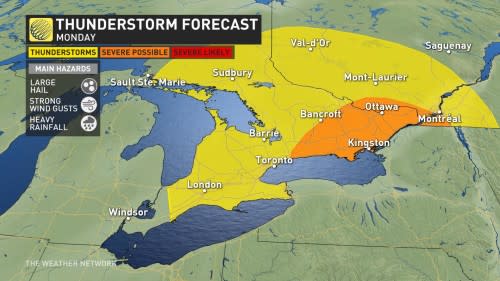
Forecasters will also watch to see if the risk for severe weather moves closer into the Greater Toronto Area.
Stay alert for rapidly changing conditions in your area, and have a plan in place to seek shelter if dangerous weather threatens.
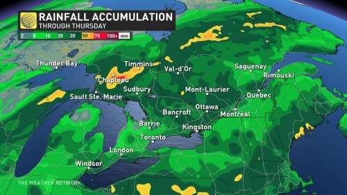
Plenty of rain over the next week
Conditions will remain unsettled through the middle of the week as continuing rounds of showers swing through southern Ontario.
CHECK IT OUT: How you can transform a small balcony space into a large garden
Most communities throughout the region will see 10-30 mm of rain over the next seven days, with amounts varying by location due to the scattered nature of the showers and storms.
Below-seasonal temperatures will dominate the final days of May and heading into the first week of June. Daytime highs will only reach the upper teens for most communities through Thursday, with sunshine for the latter half of the week pushing temperatures back toward the lower 20s.
Stay with The Weather Network for the latest on your stormy forecast across Ontario.

