
Evacuations underway as floods overtake Charlotte-area neighborhoods on Tuesday
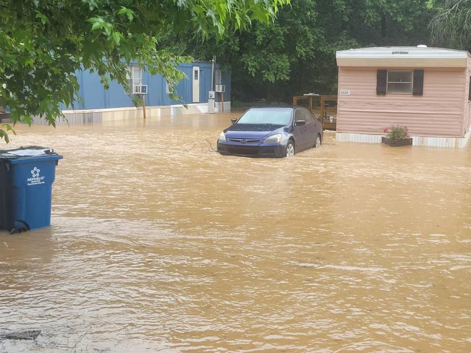
Evacuations were underway in Kannapolis Tuesday on the second straight day and night of heavy rains across the Charlotte region, a city spokeswoman said.
About 30 people were evacuated from homes along Tiffany Avenue Tuesday afternoon, spokeswoman Annette Privette Keller said.
No one was hurt, and the American Red Cross was assisting displaced residents, she said.
At 4 p.m., low-lying streets across Kannapolis were closed, including Louise Avenue, Marie Avenue, Waldorf Drive, Mable Avenue, 22nd Street, Pine Street, Tiffany Avenue, Cadillac Street and Pump Station Road, Privette Keller said.
Flooding also closed the Rocky River and Irish Buffalo Creek greenways, Safrit Park, and the Village Park carousel, splash pad and train, she said.
At 6 p.m., roads were flooding “in numerous areas” in the Charlotte region, the National Weather Service office in Greer, South Carolina, reported on Twitter.
“If you come across a flooded roadway, TURN AROUND!” NWS meteorologists said on Twitter. “You don’t know the condition of the roads underneath the water and could endanger yourself AND rescuers who arrive to help!”
The Charlotte area already was so saturated that trees could topple and roads could flood, National Weather Service meteorologist Ashley Rehnberg warned earlier Tuesday.
Tuesday’s heaviest downpours in Charlotte were forecast to occur between 1 and 3 p.m., with a break from 4 to 5 p.m. and more rain dumps between 8 and 9 p.m., Rehnberg said.
Charlotte could see 1/ 1/2 to 2 inches of rain Tuesday, she said.
Storms were not expected to be as severe as Monday night, Rehnberg said.
Tornado warnings were issued for the Lake Norman, Kannapolis and Salisbury areas Monday evening after funnel clouds were spotted in the sky, but none of them touched down, according to the Greer office.
Yet sporadic heavy downpours Tuesday afternoon and evening could further loosen soil and knock down trees, Rehnberg said.
And showers and thunderstorms will remain through the week, with the chance 80 to 100%, according to the NWS Charlotte forecast at 1 p.m. Tuesday.
Flood watch in Charlotte region
Mecklenburg and surrounding counties are under a flood watch until Thursday afternoon.
“An additional 4 to 6 inches of rain will be possible over the North Carolina Piedmont through Thursday, falling on areas that have already received several inches of rain over the past 24 hours,” according to Tuesday’s flood watch alert.
“This will make ongoing flooding worsen and likely cause new flash flooding to develop.”
The Flood Watch was expanded.
A Moderate risk for flash flooding is in place today, mainly along the eastern escarpment of the Blue Ridge Mountains into the NC Foothills & the north-central SC Upstate.
The rainfall map shows amounts from today into early Friday morning. pic.twitter.com/JmPO9VdwBP— NWS GSP (@NWSGSP) June 20, 2023

