
Noisy overnight storms set to rumble through southern Ontario
Friday saw a significant round of severe thunderstorms sweep through portions of eastern Ontario and southern Quebec, producing large hail, high winds, and even a reported funnel cloud through the afternoon and evening hours.
PHOTOS: Intense hail, high winds slam Ottawa and eastern Ontario on Friday
An intense hailstorm hit the National Capital Region in the 3:00 p.m. hour, pelting communities across the area with hail as large as golf balls.
While Friday’s storms wane with the sunset, we’ll see a new round of thunderstorms develop over the southern Great Lakes and threaten southern Ontario through the overnight hours into Saturday morning.
Well that was intense! Almost golf ball sized hail for 5 minutes (central Ottawa). @weathernetwork @ConnorMockettWX pic.twitter.com/j2i4g8d9Yd
Well that was intense! Almost golf ball sized hail for 5 minutes (central Ottawa). Paula Roy Constantly Cooking on Twitter: "Well that was intense! Almost golf ball sized hail for 5 minutes (central Ottawa). @weathernetwork @ConnorMockettWX pic.twitter.com/j2i4g8d9Yd / Twitter" Paula Roy Constantly Cooking on Twitter: "Well that was intense! Almost golf ball sized hail for 5 minutes (central Ottawa). @weathernetwork @ConnorMockettWX pic.twitter.com/j2i4g8d9Yd / Twitter" Paula Roy Constantly Cooking on Twitter: "Well that was intense! Almost golf ball sized hail for 5 minutes (central Ottawa). @weathernetwork @ConnorMockettWX pic.twitter.com/j2i4g8d9Yd / Twitter"
— Paula Roy Constantly Cooking (@paulajroy) Paula Roy Constantly Cooking on Twitter: "Well that was intense! Almost golf ball sized hail for 5 minutes (central Ottawa). @weathernetwork @ConnorMockettWX pic.twitter.com/j2i4g8d9Yd / Twitter"
Friday overnight into Saturday morning
Areas: Southwestern Ontario and the Golden Horseshoe
Timing: After midnight and through Saturday morning
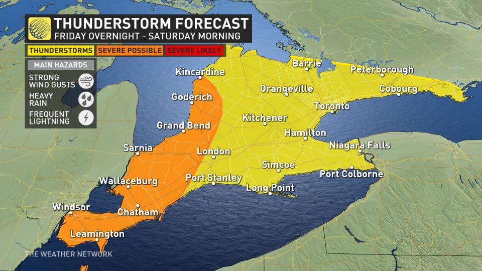
Weather: A disturbance moving across the southern Great Lakes will spark a cluster of strong thunderstorms on Friday night, which forecasters expect to move into southwestern Ontario after the midnight hour.
These storms will trek through southern Ontario overnight, moving toward the Greater Toronto Area by early Saturday morning.
DON'T MISS: Why nocturnal thunderstorms can be particularly dangerous
Communities affected by these overnight storms could see strong wind gusts, large hail, and frequent lightning. A wealth of tropical moisture aloft will allow these storms to produce heavy rainfall, which could lead to localized flooding in some areas.
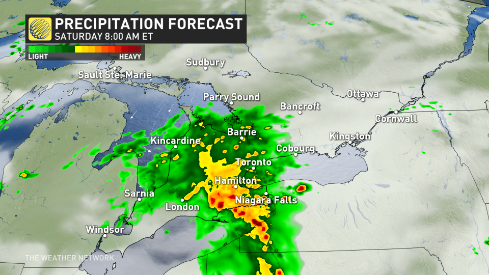
Folks across the Golden Horseshoe are likely to wake up to steady rain and rumbles of thunder on Saturday morning.
But fear not—the day won’t be a total write-off.
Forecasters expect conditions to clear up by the lunch hour, with lower humidity following soon after to make for a pleasant remainder of the weekend.
Prepare
Make sure to keep up-to-date on your local forecast information and alerts. If you are outdoors in an area with a severe weather threat, make sure you have a safety plan in place in case you need to get to shelter.
If a severe thunderstorm approaches your location, remain mindful of trees or tree limbs that loom near your home. Trees falling into buildings are a significant source of injury during strong storms. Try to avoid rooms where trees may cause damage during high winds.
The greatest danger in any thunderstorm is lightning. If you can hear thunder, you’re close enough to be struck by lightning.
Stay with The Weather Network for more forecast information and updates for your weather in Ontario.

