
Northeast, Midwest brace for rain, wind and snow before Thanksgiving


Following a burst of chilly air to end the weekend, a bigger problem awaits Thanksgiving travelers in the Northeast and Midwest in the week to come as a potent storm will take shape and spin toward the Great Lakes, triggering areas of heavy rain, snow and gusty winds, AccuWeather meteorologists say.
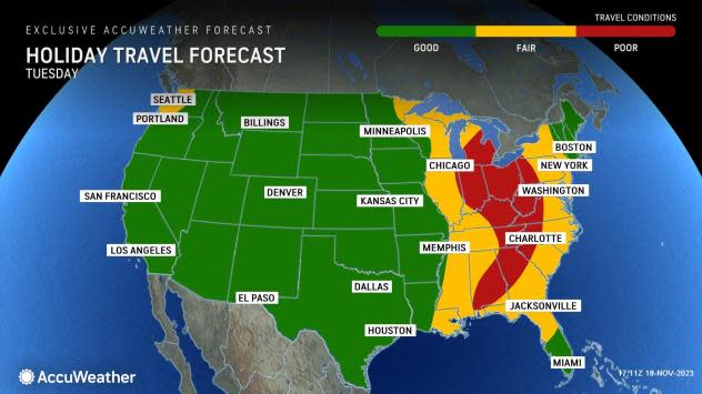
There is the potential for the weather to throw a wrench into Thanksgiving travel before the holiday as a storm focuses on major highways and airport hubs from Chicago to New York City.
The storm will likely trigger airline delays and may lead to some flight cancellations. The American Automobile Association (AAA) anticipates that close to 4.7 million people will travel by air during the approximate week-long period around Thanksgiving.
There will be trouble on the highways as well, as the rain will not only lead to wet roads and require additional braking distance but also vast stretches of the Interstate 80, 81 and 95 corridors, for example, may experience ponding that can raise the risk of vehicles hydroplaning. During the high volumes of traffic expected, the reduced visibility and wet conditions can create dangerous conditions. Nearly 50 million motorists are expected to take to the roads in the days surrounding Thanksgiving, according to AAA.
 |
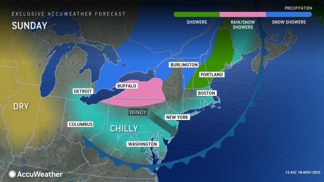
In the wake of a cold front that produced a period of rain across the Northeast Friday night into Saturday, chillier and more seasonable air will sweep from the Great Lakes to the Northeast through the remainder of the weekend.
Travel problems due to the burst of wintry weather and brief snow showers that can occur on Sunday from southern Ontario to southern New York and northern New England will be brief and localized. Still, motorists should be prepared for sudden drops in visibility and a quick coating of snow in some cases.
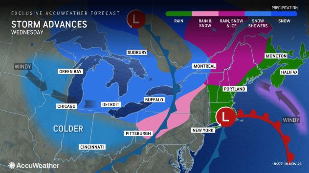
The main focus of travel problems will arise as a storm forms over the south-central United States and strengthens while traveling northeastward into the middle of this week.
 |
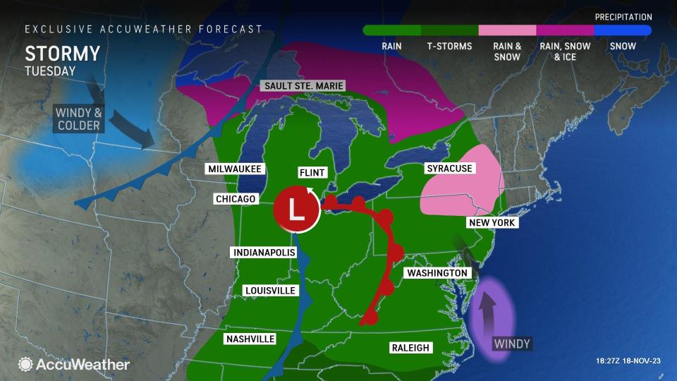
After triggering locally severe thunderstorms over the lower Mississippi Valley on Monday, the storm will spread a swath of rain over the Ohio and Tennessee valleys on Monday night. Rain will spread over the Great Lakes and central and southern Appalachians on Tuesday.
Airline passengers and motorists in Chicago, Detroit, Cincinnati, Cleveland and perhaps even Pittsburgh can expect drenching rain to begin sometime Monday night, with a thorough soaking expected for many on Tuesday.
 |
There is even the chance that just enough cold air will be around on the northwestern flank of the storm to allow snow to mix in from parts of northern Illinois and Wisconsin to northern Michigan.
In much of the Midwest, a sweep of dry and colder air is in store by Wednesday, but gusty crosswinds may continue to lead to localized trouble at some area airports. Crosswinds may force officials to allow extra landing and takeoff time for aircraft, which requires extra aircraft spacing on approach or even a holding pattern when winds kick up.
From there, rain will continue to push along into the mid-Atlantic and parts of New England on Tuesday night, before moving out to sea and on into Canada on Wednesday night.
 |
As the rain and low visibility associated with low clouds and fog settle into the major hubs and highways in the Northeast, airline and roadway delays will likely mount on Tuesday afternoon and night in the zone from Washington, D.C., to Philadelphia and New York City.
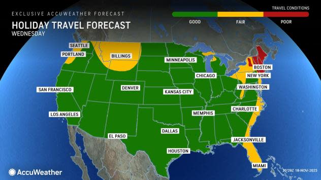
The heaviest rain and most adverse conditions will likely affect the Boston area on Wednesday.
 |
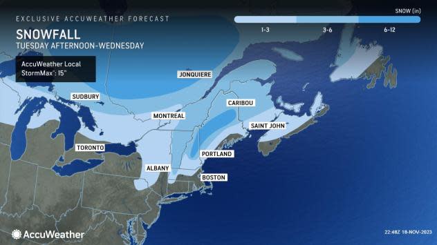
As the storm encounters the colder air in the Northeast, pockets of ice and snow are possible from upstate New York to parts of central and northern New England for a time. The greatest risk for accumulating snow will be across Canada and into northern New England, where up to a foot of snow may fall from central New Hampshire into northern Maine.
Travel conditions are expected to slowly improve from west to east across the Northeast late Wednesday, but localized crosswinds are possible at some of the airport hubs due to blustery conditions in the afternoon and at night.
Because the air coming in behind the storm will be quite chilly, some of the most significant bands of lake-effect snow of the season so far could develop, should the winds in the atmosphere be in alignment for such a scenario to occur.
 |
Motorists may need to watch out for areas of slippery roads and poor visibility in snow and blowing snow in the traditional lake-effect snowbelts.
For those traveling any distance on Thanksgiving Day and Black Friday, mainly dry and clear conditions are in store across much of the eastern two-thirds of the nation.
Want next-level safety, ad-free? Unlock advanced, hyperlocal severe weather alerts when you subscribe to Premium+ on the AccuWeather app. AccuWeather Alerts™ are prompted by our expert meteorologists who monitor and analyze dangerous weather risks 24/7 to keep you and your family safer.
