
Flood risk for the East Coast with heavy rain after historic weekend snow

A busy spell of active weather rolls into the new workweek across the East Coast as a dynamic storm blankets the region.
Heavy rain that arrived in the Maritimes on Sunday isn’t leaving in a hurry. Colder air to the north will force snow to persist in parts of New Brunswick, as well.
Newfoundland is in for a sloppy mix of rain and snow, which is no picnic after a historic snowstorm slammed parts of the island with 40-80 cm just a few days ago.
Cleaning up in downtown St.John's NLCanada 🇨🇦. @weathernetwork @LFB10 @nadinehp4 @laurapowerwx @HowesNathan #ShareYourWeather #nlwx March 10,2024 pic.twitter.com/DF9ENoToOI
Cleaning up in downtown St.John's NL
Canada 🇨🇦. Colin Lane on Twitter: "Cleaning up in downtown St.John's NLCanada 🇨🇦. @weathernetwork @LFB10 @nadinehp4 @laurapowerwx @HowesNathan #ShareYourWeather #nlwx March 10,2024 pic.twitter.com/DF9ENoToOI / Twitter" Colin Lane on Twitter: "Cleaning up in downtown St.John's NLCanada 🇨🇦. @weathernetwork @LFB10 @nadinehp4 @laurapowerwx @HowesNathan #ShareYourWeather #nlwx March 10,2024 pic.twitter.com/DF9ENoToOI / Twitter" Colin Lane on Twitter: "Cleaning up in downtown St.John's NLCanada 🇨🇦. @weathernetwork @LFB10 @nadinehp4 @laurapowerwx @HowesNathan #ShareYourWeather #nlwx March 10,2024 pic.twitter.com/DF9ENoToOI / Twitter" Colin Lane on Twitter: "Cleaning up in downtown St.John's NLCanada 🇨🇦. @weathernetwork @LFB10 @nadinehp4 @laurapowerwx @HowesNathan #ShareYourWeather #nlwx March 10,2024 pic.twitter.com/DF9ENoToOI / Twitter" Colin Lane on Twitter: "Cleaning up in downtown St.John's NLCanada 🇨🇦. @weathernetwork @LFB10 @nadinehp4 @laurapowerwx @HowesNathan #ShareYourWeather #nlwx March 10,2024 pic.twitter.com/DF9ENoToOI / Twitter" Colin Lane on Twitter: "Cleaning up in downtown St.John's NLCanada 🇨🇦. @weathernetwork @LFB10 @nadinehp4 @laurapowerwx @HowesNathan #ShareYourWeather #nlwx March 10,2024 pic.twitter.com/DF9ENoToOI / Twitter" Colin Lane on Twitter: "Cleaning up in downtown St.John's NLCanada 🇨🇦. @weathernetwork @LFB10 @nadinehp4 @laurapowerwx @HowesNathan #ShareYourWeather #nlwx March 10,2024 pic.twitter.com/DF9ENoToOI / Twitter" March 10,2024 Colin Lane on Twitter: "Cleaning up in downtown St.John's NLCanada 🇨🇦. @weathernetwork @LFB10 @nadinehp4 @laurapowerwx @HowesNathan #ShareYourWeather #nlwx March 10,2024 pic.twitter.com/DF9ENoToOI / Twitter"— Colin Lane (@ColinLa709) Colin Lane on Twitter: "Cleaning up in downtown St.John's NLCanada 🇨🇦. @weathernetwork @LFB10 @nadinehp4 @laurapowerwx @HowesNathan #ShareYourWeather #nlwx March 10,2024 pic.twitter.com/DF9ENoToOI / Twitter"
We’re also looking at the chance for more snow in the Maritimes by Tuesday.
PHOTOS: Messy winter storm blankets parts of Newfoundland
Monday: Heavy rain follows historic snow to start this week
A strong low-pressure system will take its time moving across Atlantic Canada over the next couple of days. The centre of the storm moved over the heart of the Maritimes, dividing the region between heavy rain and heavy snow.
The rain picked up for southern portions of New Brunswick and Nova Scotia Sunday night, as warm air and plenty of moisture fuelled steady downpours. Meanwhile, heavy, wet snow spread across the northern half of New Brunswick.
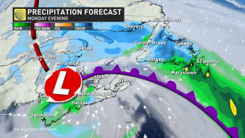
The system will gradually make its way east throughout the day Monday, forcing precipitation to cross the Gulf and begin washing over Newfoundland, including St. John's where a rainfall and wind warning is in effect.
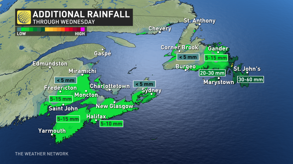
Wet snow spreads across central sections of the province into the afternoon hours, while a wintry mix targets the Avalon as temperatures hover just above the freezing mark. Between 30-60 mm of rain is forecast for the Avalon into Wednesday, which could result in localized flooding.
The combination of rain, milder temperatures and strong winds will cause significant melting of the snow from the recent heavy blast, which will likely produce a lot of water runoff.
"Be sure to clear snow and ice from storm drains and gutters," says Environment and Climate Change Canada in a rainfall warning issued for the region. "Flooding is possible in places in the lowlands."
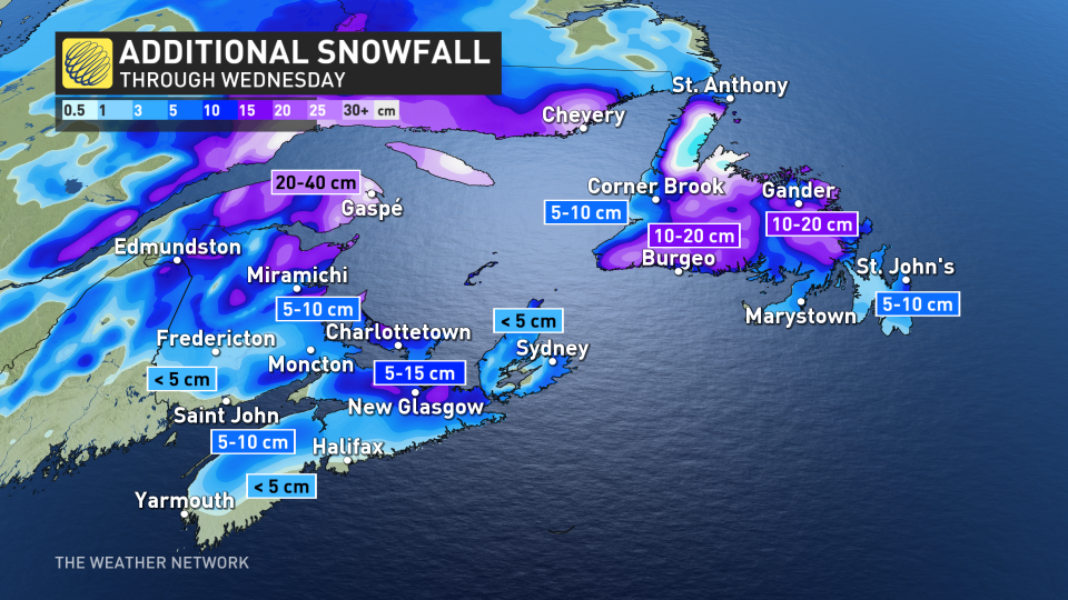
Due to the borderline temperatures across the island, the snowfall will be highly elevation dependent, with a large range in totals away from the water and across higher terrain. Between 10-15 cm of snow is forecast across higher portions of the eastern Avalon, with 10-20 cm of wet snow likely across areas of central Newfoundland.
RELATED: Be aware of your heart while shovelling heavy snow
Wind gusts up to 90 km/h will blow across southern and eastern Newfoundland.
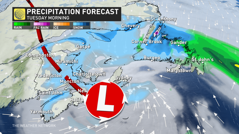
Tuesday: Snow risk increases as storm stalls
Snow will continue in Newfoundland on Tuesday as the low-pressure system lingers over the region for another day. We’ll see better odds of mixed precipitation and wet snow creep into the Avalon as the atmosphere cools over the peninsula.
DON'T MISS: Everything you need to know for April's spectacular and rare solar eclipse
Farther south, though, we’ll have to watch the potential for wrap-around snow to blanket parts of the Maritimes.
As of now, it looks like the Maritimes could see a shovellable snow through Tuesday, with 5-15 cm possible, locally.
Stay with The Weather Network for all the latest on your forecast for Atlantic Canada.
Thumbnail image courtesy: Colin Lane/X

