
Snowy system tracks into southern Alberta and threatens Thursday's commute

It wouldn’t be winter in Alberta without large temperature swings that change from day to day. After temperatures rose into the mid-teens across southern Alberta earlier this week, we are now watching for quite the major temperature tumble, followed by some snow.
DON'T MISS: From blizzards to record warmth: Nunavut experiencing weather turmoil
The infamous chinook winds helped push daytime highs to around 20 degrees above normal in some locales on Tuesday. Gusts were projected to peak at or around 100 km/h, giving a pleasant assist in the unseasonable warmth.
Much colder temperatures, comparatively speaking, will return to the province for Wednesday and the rest of the week. Along with that, people can expect snowfall to make its comeback, too.
Wednesday into Thursday: Goodbye warmth, hello snow!
On Tuesday, Bow Island recorded a balmy 18.6°C, Calgary airport documented a reading of 17°C, its seventh-warmest December temperature on record, and Medicine Hat hit 18°C, its fourth-warmest December temperature on record.
After some of the warmest temperatures on record in December, snow is in the forecast for southern parts of Alberta.

The moisture from the pineapple express in B.C. is going to cross the Rockies and spill into the Prairies.
WATCH: Calgary, snow may impact your Thursday morning commute
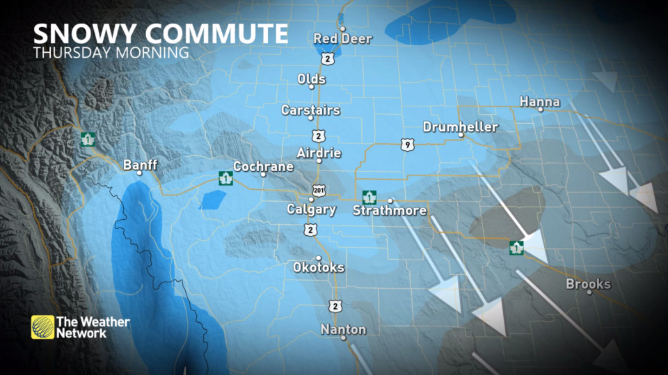
Snow is forecast to start for areas along the QE2 and Trans-Canada Highway after the evening commute on Wednesday, beginning near Red Deer. Snow will continue to fall through the overnight and migrate south towards Calgary during the Thursday morning commute. Some snowfall may push as far north as Edmonton, possibly breaking the snowless November streak for the city.
Breezy conditions can reduce visibility on the roads as it blows the snow around. Roads will also be slippery, and drivers may be caught off guard after the warmth experienced on Tuesday, so brace for tricky travel throughout the event.
Conditions improve through the afternoon as the system tracks east.
Between 5-10 cm is possible in the heaviest swath of snow that is forecast from Red Deer to Calgary.
Going somewhere? Check out the current highway conditions before heading out!
This comes after a month of below seasonal snow in November, when Calgary only received 5.2 cm for the entire month.

The good news is that no major systems are expected for next week.
For a look at what Alberta can expect during the winter, check out The Weather Network's seasonal outlook, here.
Stay tuned to The Weather Network for the latest forecast updates for Alberta.

