
Southern Ont., Quebec looking at most severe weather day of the season Thursday
Muggy air is starting to build back in across parts of Ontario and Quebec, with all eyes on Thursday's forecast and the severe weather threats that come with it.
With the increasing heat and high humidity, comes instability in the atmosphere. A cold front moving through Ontario on Thursday will trigger a risk for thunderstorms, with the chance for some to become severe.
In fact, Thursday has the potential to be the most severe weather day of the season so far for southern Ontario and western Quebec, so it will be important to stay on top of the weather watches and warnings in your area, as conditions can change quickly when severe weather hits.
DON'T MISS: What to do if a tornado warning is issued
Thursday: Severe weather to bubble up across the province
A strong cold front pushing eastward through the lower Great Lakes region this week will clash with the warm, humid air in place, triggering widespread rain and embedded thunderstorms in its path.
While parts of northern Ontario will see the severe weather conditions first on Wednesday, the real risk comes to southern and eastern Ontario, and western Quebec later Thursday.
SEE ALSO: The Great Lakes may have a thunderous effect on your summer weather
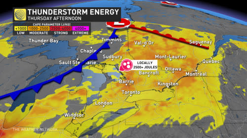
Temperatures in the mid- to high-20s will feel like the mid-30s with the humidity on Thursday. Folks in Toronto will be seeing an already scorching daytime high in the upper 20s, but the humidex will make it feel well into the 30s. This will create enough energy in the atmosphere for strong storms to develop upon the cold front's arrival later in the day.
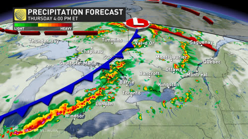
There is the potential for a few showers or thunderstorms on Thursday morning, but there should be sufficient clearing in the afternoon to recharge the atmosphere ahead of the passage of the cold front.
By the late afternoon, and as the cold front nears, the more intense thunderstorms are likely to continue into the evening hours.
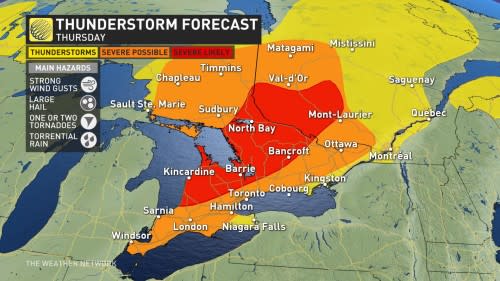
Torrential rain, strong wind gusts, large hail, and even a tornado or two are strong possibilities for Thursday. Be sure to be weather-aware as damage is possible given the severity of this system.
The dreary, stormy weather will stick around through the overnight Thursday, giving Friday a less-than-ideal start. Things will turn around in a hurry however, with the region finally looking to pull off a dry weekend -- the first in the GTA since early April!
Saturday will be a gorgeous day with abundant sunshine, light wind and comfortable temperatures during the afternoon. A mix of sun and clouds is expected for Sunday.
MUST SEE: Will the streak finally end with a dry Father's Day weekend?
By next week, conditions will become hot and very humid for most of the week, with high temperatures soaring into the low to mid 30s for a few days, and a 40+ humidex. However, with the very muggy conditions will come a risk for thunderstorms, once again.
Warmer than normal temperatures are expected to dominate through the end of the month, but quick shots of cooler weather near seasonal, are also are possible.
Stay with The Weather Network for more forecast information and updates on your weather across Ontario and Quebec.

