
Rounds of thunderstorms move through southern Ontario with heavy rain
Wednesday was likely an early wake-up call for many southern Ontarians, as flashes of lightning and loud rumbles of thunder hit before dawn. The warm front associated with the impactful and far-reaching system moved through the region setting off the first round of thunderstorms in its wake.
"The thunder this morning sounded quite loud and that is because these storms are elevated in nature with stable air at the surface, which allows sound to propagate easier and sound louder than normal," explains Matt Grinter, a meteorologist at The Weather Network.
Good morning Ontario! What a wake-up call. @StormhunterTWN @LauraDuchesne #ONStorm pic.twitter.com/FHAULOpoTz
Good morning Ontario! What a wake-up call. W. Scott Hammond 📷🌪⚡️ on Twitter: "Good morning Ontario! What a wake-up call. @StormhunterTWN @LauraDuchesne #ONStorm pic.twitter.com/FHAULOpoTz / Twitter" W. Scott Hammond 📷🌪⚡️ on Twitter: "Good morning Ontario! What a wake-up call. @StormhunterTWN @LauraDuchesne #ONStorm pic.twitter.com/FHAULOpoTz / Twitter" W. Scott Hammond 📷🌪⚡️ on Twitter: "Good morning Ontario! What a wake-up call. @StormhunterTWN @LauraDuchesne #ONStorm pic.twitter.com/FHAULOpoTz / Twitter" W. Scott Hammond 📷🌪⚡️ on Twitter: "Good morning Ontario! What a wake-up call. @StormhunterTWN @LauraDuchesne #ONStorm pic.twitter.com/FHAULOpoTz / Twitter"
— W. Scott Hammond 📷🌪⚡️ (@wellingtonwx) W. Scott Hammond 📷🌪⚡️ on Twitter: "Good morning Ontario! What a wake-up call. @StormhunterTWN @LauraDuchesne #ONStorm pic.twitter.com/FHAULOpoTz / Twitter"
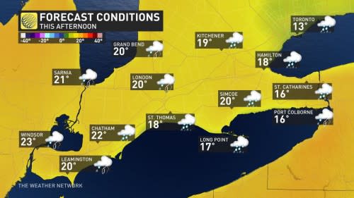
Southern Ontario continues to see the warmer side of spring throughout the day on Wednesday, while its neighbours to the east and west get quite the wintry dose. Before the noon hour, Canada's first 20°C temperature in 2023 was felt in Windsor, when the city hit 20.5°C.
DON'T MISS: Snowstorm to pack a wintry wallop in Manitoba, Ontario and Quebec
The warm and moist air is what's providing the instability needed to fuel the ongoing thunderstorm risk across southern Ontario. This risk extended into Wednesday afternoon and evening as instability peaks and the strongest lift arrives to spark the storms.
While the thunderstorm risk will stretch from northeastern Ontario, through cottage country and to the southwest, the more severe storms are likely to be from the west end of the GTA to Niagara, and down to Windsor and Sarnia Wednesday afternoon and evening. The tornado watch that was issued for the Windsor area earlier Wednesday has been discontinued.
DON’T MISS: Tick season really isn’t that far off. Get equipped to face it, here
Gusty winds, heavy rain and hail are the main threats with thunderstorms that develop.
Yes those are hail stones. Heading Kingston way. Be careful out there.#Weather @MIHomeYGK pic.twitter.com/iRuX4ZLemc
Yes those are hail stones. Heading Kingston way. Be careful out there.Grace Vanderzande 🇨🇦 on Twitter: "Yes those are hail stones. Heading Kingston way. Be careful out there.#Weather @MIHomeYGK pic.twitter.com/iRuX4ZLemc / Twitter" Grace Vanderzande 🇨🇦 on Twitter: "Yes those are hail stones. Heading Kingston way. Be careful out there.#Weather @MIHomeYGK pic.twitter.com/iRuX4ZLemc / Twitter" Grace Vanderzande 🇨🇦 on Twitter: "Yes those are hail stones. Heading Kingston way. Be careful out there.#Weather @MIHomeYGK pic.twitter.com/iRuX4ZLemc / Twitter"
— Grace Vanderzande 🇨🇦 (@ButtonsThoughts) Grace Vanderzande 🇨🇦 on Twitter: "Yes those are hail stones. Heading Kingston way. Be careful out there.#Weather @MIHomeYGK pic.twitter.com/iRuX4ZLemc / Twitter"
The greater risk for tornado development will be in Michigan, where the parameters are more favourable and there is less of a cooling influence from the Great Lakes.
CANADA’S APRIL OUTLOOK: Will spring’s sluggish start continue this month?
WATCH: Severe storms push across southern Ontario with several rounds yet to come
Warmup for GTA Wednesday evening, storm risk remains
Throughout the afternoon, we will see some breaks in the precipitation, but not everyone will feel the warmth. A stubborn east wind will likely delay a temperature warmup across the GTA until later Wednesday evening.
Rainfall amounts will be heaviest near Lake Huron and Georgian Bay shores, as well as the eastern end of Lake Ontario, where 40-60 mm is possible. Between 30-50 mm is possible for areas just inland of Lake Huron and Georgian Bay, and parts of cottage country. Widespread totals of 10-30 mm are possible elsewhere, with higher amounts likely in thunderstorms.
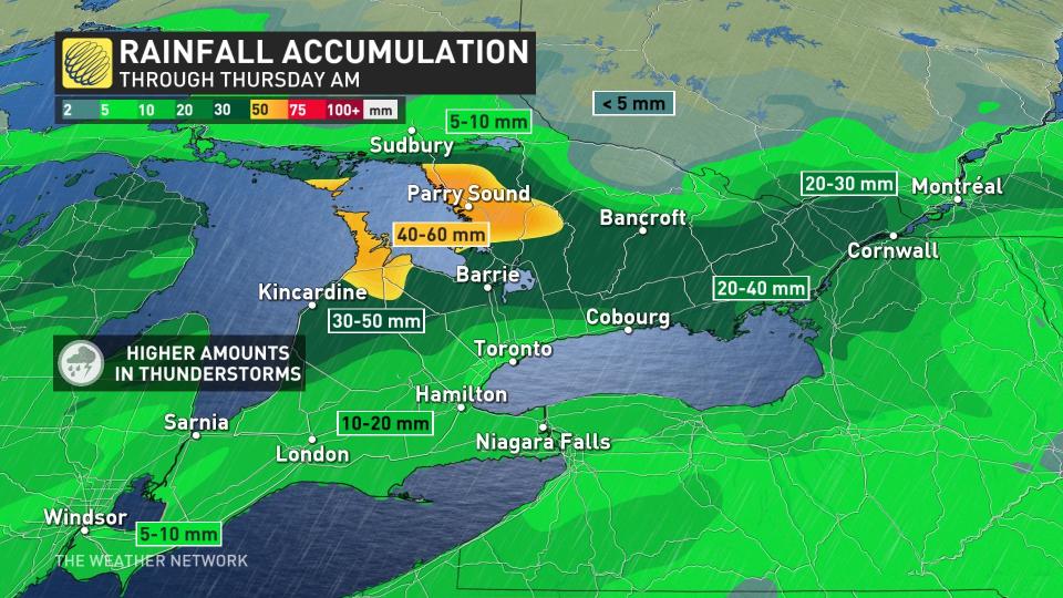
The rainfall will add to the flood-hit areas in the southwest, particularly the Grand Bend watershed, which has a watch in effect still.
By Wednesday night, the rain clears out of the GTA and westward, but will continue through eastern Ontario before ending by Thursday morning. The widespread gusty winds will ease a bit Wednesday night, but becoming gusty again Thursday behind the system.
WATCH: Large storm system brings severe weather to millions of Canadians
Temperatures cool significantly for start of Easter weekend
Much colder conditions are expected late week, especially for Good Friday with temperatures sitting well below seasonal.
Fair weather and a warming trend will pick up through the long weekend, with pleasant spring weather on tap for Easter Sunday. Conditions will turn briefly colder early next week, but the period of cooler weather looks less significant than it did last week.
Temperatures should quickly rebound as we head into mid-April.
Stay tuned to The Weather Network for the latest forecast updates for southern Ontario.

