Summer takes a vacation as gloomy chill, snow descend on B.C.
Summer-like temperatures are going on hiatus along the West Coast this week as a familiar pattern settles back across the region.
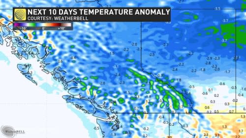
This month is shaping up to look quite different from the past few Junes we’ve seen across British Columbia, with much wetter and cooler conditions sticking around. We could even notch our coolest June since 2020 at the rate we’re going.
DON’T MISS: A+? C-? Grading this week’s weather outlook across Canada

We’re only a week and a half into June and it’s already a soggy one. Vancouver has seen 39.1 mm up to this point in the month, which is more than double what we’d seen by this point in June last year.
The wet weather may be annoying, but it’s fantastic news for the fire season. Recent precipitation has kept the fire danger rating in the low to moderate categories for much of the province.
This is all despite the warmer-than-normal weekend we just experienced across the Lower Mainland, with temperatures cracking the 30-degree mark in spots as readings jumped 8-10 degrees warmer than normal.
WATCH: June-uary is here! Why the gloomy skies aren't such a bad thing
Cooler, wetter week ahead
A pattern change will usher that heat ridge off toward the Prairies and let a familiar pattern return to the coast in time for the new workweek.
This week’s weather will be driven by a large centre of low pressure swirling over the Gulf of Alaska.

SEE ALSO: B.C. politicians debate reflooding Sumas Prairie
We’ll see this low-pressure system slowly move inland across the province later in the weekend, serving as the catalyst for the unsettled weather that’ll drape over the region through the middle of the month.
Several periods of precipitation will wash ashore over the next week, with the most solid batch of rain arriving Tuesday and Wednesday. The heaviest rain should fall along the typical spots across the South Coast’s higher elevations, as well as western Vancouver Island around Tofino.

Conditions will remain on the cooler side as a result of this low-pressure system dominating the West Coast. Temperatures aloft will remain well below seasonal, with freezing levels falling to 1500 m this week across Vancouver Island and the Coastal Mountain ranges.

This chilly pattern will lead to the potential for June snow across areas where temperatures are typically 5-10 degrees above freezing. Pockets of accumulating snow are possible.
Stay with The Weather Network for all the latest on your forecast across British Columbia.


