
Tale of two seasons means Ontario sees stormy conclusion to March
As we get ready to wrap up the month of March and move deeper into the spring season, much of Ontario remains under an active storm track with rounds of stormy weather moving through this week.
The precipitation types will depend on temperatures and location, but could range from heavy snow and dangerous whiteout conditions to graupel and soggy rains with strong winds.
MUST SEE: March madness: Canada’s month-long, wild ride of weather
The first round will move into northern Ontario on Wednesday morning, bringing another swath of 2-5+ cm of snow as a cold pattern dominates during the final days of March.

A frontal squall associated with a strong cold front will race across southern and eastern Ontario Wednesday afternoon. The precipitation could briefly start as rain, as temperatures will be quite mild ahead of the cold front, but then quickly change to graupel and a burst of heavy snow with strong winds that could create poor visibility.
RELATED: What is graupel? We break down this often misunderstood precipitation type
While accumulation across the south will be pretty minimal, if any at all, with the quick burst of snow, near whiteout conditions are likely during the squall and could greatly impact travel later Wednesday.
Temperatures will drop well below freezing behind the front, as well, taking a significant tumble from the almost double-digit highs on Wednesday afternoon.
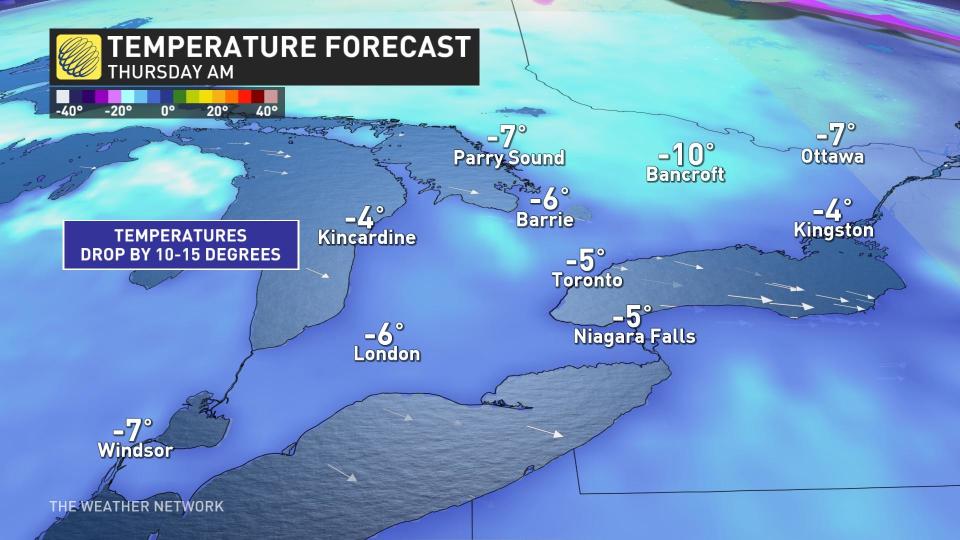
There will be a brief break on Thursday, with sunny and cool conditions expected, before the next system that moves in for Friday and ends off the month on a wet and windy note.
WATCH: Voting is underway for Ontario's worst road, but does it make a difference?
Colorado low to spread heavy rain and winds to end off March, with more heavy snow to the north
A widespread rain and very mild temperatures are forecast Friday and into Saturday. Double-digit temperatures are likely across southern Ontario, with the potential to reach the mid-teens in some areas.
The system, however, will bring in 20-30 mm of rain along with strong winds, making for a miserable end to the week and month.
DON’T MISS: Allergy season is coming. Get ahead of it with these must-haves

During the overnight hours and into Saturday morning, a cold front moves through and could bring a quick burst of flurries before the system ends.
On the north side of the system, another swath of heavy snow will push into the region, with as much as 10-20 cm possible across parts of northeastern Ontario into Saturday.

An active pattern with changeable temperatures is expected to continue through the first week of April as a few more significant systems track across the region.
Be sure to check back for the latest weather updates across Ontario.

