
Early season snowfall kicks off November across Atlantic Canada
Atlantic Canada got the first taste of the winter season with a shot or two of snowfall across parts of the region on Monday. Now, a more widespread snow is threatening difficult travel for some through Wednesday.
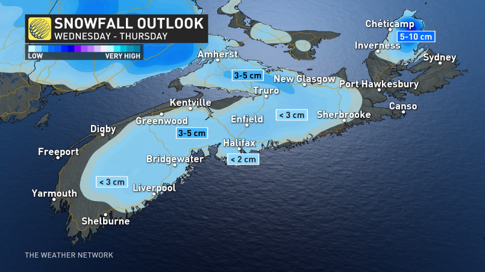
This will be the first snowfall of the season for parts of southern Nova Scotia, including Halifax, this time around.
MUST SEE: Warm or wintry? Halloween weekend holds a mixed bag for Canada
Drivers are being urged to plan ahead, especially with this likely being the first dose of winter travel for many motorists.
Wednesday
Low pressure will develop over the Atlantic and rapidly intensify as it tracks south of the Maritimes on Wednesday, then heading towards the Avalon Peninsula Wednesday night and into Thursday. This will put Nova Scotia and central Newfoundland in the crosshairs for accumulating wet snowfall and breezy conditions.
This forecast is naturally going to be in flux as temperatures hover around the freezing mark, and small wobbles in the track will make all the difference.

Nova Scotia is up first. Snow began to fall across the southwest Wednesday morning, building into Halifax and east throughout the day. Immediate shorelines may see a rain snow mix for periods of time, limiting accumulations there. But further inland, and at higher elevations, there's a better chance for a white coating on the grass, with up to 3-5 cm possible.
Winds onshore may reach 40 km/h in the south until conditions ease Thursday.
Surfaces such as highways, roads, walkways and parking lots may become difficult to navigate with the accumulating snow and winds, and drivers are being urged to plan ahead.
MUST SEE: First snowfall leaves thousands without power in Moncton area
WATCH: Halifax is teetering towards a heavier snowfall
Snow and blowing snow conditions will be a bit more intense in west and central Newfoundland, beginning Wednesday evening.
Enough cold air, and the later timing of the system may lead to 10-20 cm accumulating by Thursday afternoon.

Winds will also pick up, gusting to 60 km/h by Wednesday evening, and up to 70 km/h Thursday morning.
This will lead to periods of whiteout conditions, especially on the stretch of the Trans-Canada Highway in and out of Badger.

St. John's will be spared by the snow as rainfall blankets the Avalon, with 20-30 mm forecast during the event.
Gander's forecast is more difficult, being predicted as a mix of rain and snow for a good chunk of the system, but one degree colder and that could bring some heavier accumulations.
Stay with The Weather Network for the latest updates across Atlantic Canada.

