
Thundersnow strikes southern Ontario (again)

As temperatures dropped in southern Ontario late Wednesday afternoon, a rare event took place in the region.
Thundersnow struck several communities. That, in itself, is unusual. But to make the event even more unique, this is the second time thundersnow struck southern Ontario this month. The first time was on March 3, and came courtesy of a Texas low that developed over the southern U.S. two days prior, pushing energy towards the Great Lakes and setting the scene for a powerful thundersnow display.
Wednesday's thundersnow is also due to movement over the Great Lakes.
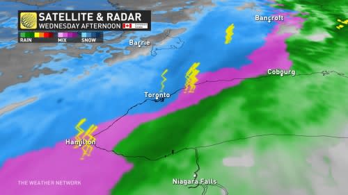
"A cold front crashing through the Great Lakes brought an intense mix of rain, snow, and even thunder and lightning to southern Ontario Wednesday," explains Weather Network meteorologist Michael Carter.
"Thundersnow is rare, but lightning can be produced by snowstorms through the same processes as summer storms. Usually, it requires a strong triggering mechanism like yesterday’s cold front."
Today we're playing every Canadian's favourite springtime game: is it snow or is it rain? Bonus points if you're already out and somehow dressed correctly for this mess.#ONStorm #thundersnow #TorontoWeather #WhatIsSleetAnywaysNoOneEverToldMeAndNowImAfraidToAsk pic.twitter.com/GTODZIhZiR
Today we’re playing every Canadian’s favourite springtime game: is it snow or is it rain?
Bonus points if you’re already out and somehow dressed correctly for this mess.Emma Jones on Twitter: "Today we're playing every Canadian's favourite springtime game: is it snow or is it rain? Bonus points if you're already out and somehow dressed correctly for this mess.#ONStorm #thundersnow #TorontoWeather #WhatIsSleetAnywaysNoOneEverToldMeAndNowImAfraidToAsk pic.twitter.com/GTODZIhZiR / Twitter" Emma Jones on Twitter: "Today we're playing every Canadian's favourite springtime game: is it snow or is it rain? Bonus points if you're already out and somehow dressed correctly for this mess.#ONStorm #thundersnow #TorontoWeather #WhatIsSleetAnywaysNoOneEverToldMeAndNowImAfraidToAsk pic.twitter.com/GTODZIhZiR / Twitter" Emma Jones on Twitter: "Today we're playing every Canadian's favourite springtime game: is it snow or is it rain? Bonus points if you're already out and somehow dressed correctly for this mess.#ONStorm #thundersnow #TorontoWeather #WhatIsSleetAnywaysNoOneEverToldMeAndNowImAfraidToAsk pic.twitter.com/GTODZIhZiR / Twitter" Emma Jones on Twitter: "Today we're playing every Canadian's favourite springtime game: is it snow or is it rain? Bonus points if you're already out and somehow dressed correctly for this mess.#ONStorm #thundersnow #TorontoWeather #WhatIsSleetAnywaysNoOneEverToldMeAndNowImAfraidToAsk pic.twitter.com/GTODZIhZiR / Twitter" Emma Jones on Twitter: "Today we're playing every Canadian's favourite springtime game: is it snow or is it rain? Bonus points if you're already out and somehow dressed correctly for this mess.#ONStorm #thundersnow #TorontoWeather #WhatIsSleetAnywaysNoOneEverToldMeAndNowImAfraidToAsk pic.twitter.com/GTODZIhZiR / Twitter"
Thundersnow typically occurs in the most intense snow bands, which is one factor that makes it so uncommon, Carter adds.
Visit our Complete Guide to Spring 2023 for an in-depth look at the Spring Forecast, tips to plan for it and much more!
But when it does occur, "it is slightly more likely near tall structures like skyscrapers and wind turbines, which give the electrical charge a shorter path to the ground."
Some thundersnow off the Huron shores and south of Collingwood! Who caught a glimpse? #ONStorm pic.twitter.com/4wjZTBLP5G
Some thundersnow off the Huron shores and south of Collingwood! Who caught a glimpse? Jessie Uppal on Twitter: "Some thundersnow off the Huron shores and south of Collingwood! Who caught a glimpse? #ONStorm pic.twitter.com/4wjZTBLP5G / Twitter" Jessie Uppal on Twitter: "Some thundersnow off the Huron shores and south of Collingwood! Who caught a glimpse? #ONStorm pic.twitter.com/4wjZTBLP5G / Twitter"
— Jessie Uppal (@JessieUppal_) Jessie Uppal on Twitter: "Some thundersnow off the Huron shores and south of Collingwood! Who caught a glimpse? #ONStorm pic.twitter.com/4wjZTBLP5G / Twitter"
Pretty crazy thunder snow ❄️ ⚡️ happening in Oshawa right now #ONStorm @weathernetwork @StormhunterTWN pic.twitter.com/TcNhaJCKYV
Pretty crazy thunder snow ❄️ ⚡️ happening in Oshawa right now ⱧɄ₦₮ɆⱤ.Ɇ 🇨🇦🏒 on Twitter: "Pretty crazy thunder snow ❄️ ⚡️ happening in Oshawa right now #ONStorm @weathernetwork @StormhunterTWN pic.twitter.com/TcNhaJCKYV / Twitter" ⱧɄ₦₮ɆⱤ.Ɇ 🇨🇦🏒 on Twitter: "Pretty crazy thunder snow ❄️ ⚡️ happening in Oshawa right now #ONStorm @weathernetwork @StormhunterTWN pic.twitter.com/TcNhaJCKYV / Twitter" ⱧɄ₦₮ɆⱤ.Ɇ 🇨🇦🏒 on Twitter: "Pretty crazy thunder snow ❄️ ⚡️ happening in Oshawa right now #ONStorm @weathernetwork @StormhunterTWN pic.twitter.com/TcNhaJCKYV / Twitter" ⱧɄ₦₮ɆⱤ.Ɇ 🇨🇦🏒 on Twitter: "Pretty crazy thunder snow ❄️ ⚡️ happening in Oshawa right now #ONStorm @weathernetwork @StormhunterTWN pic.twitter.com/TcNhaJCKYV / Twitter"
— ⱧɄ₦₮ɆⱤ.Ɇ 🇨🇦🏒 (@Leafs_Fan_905) ⱧɄ₦₮ɆⱤ.Ɇ 🇨🇦🏒 on Twitter: "Pretty crazy thunder snow ❄️ ⚡️ happening in Oshawa right now #ONStorm @weathernetwork @StormhunterTWN pic.twitter.com/TcNhaJCKYV / Twitter"
Clip of the #thundersnow near the wind turbines in Orono, Ontario. My camera was pointed towards the turbines but it was a complete whiteout. #Onstorm #onwx pic.twitter.com/tKrlcIWBhG
Clip of the Alex Todd 🌪 on Twitter: "Clip of the #thundersnow near the wind turbines in Orono, Ontario. My camera was pointed towards the turbines but it was a complete whiteout. #Onstorm #onwx pic.twitter.com/tKrlcIWBhG / Twitter" near the wind turbines in Orono, Ontario. My camera was pointed towards the turbines but it was a complete whiteout. Alex Todd 🌪 on Twitter: "Clip of the #thundersnow near the wind turbines in Orono, Ontario. My camera was pointed towards the turbines but it was a complete whiteout. #Onstorm #onwx pic.twitter.com/tKrlcIWBhG / Twitter" Alex Todd 🌪 on Twitter: "Clip of the #thundersnow near the wind turbines in Orono, Ontario. My camera was pointed towards the turbines but it was a complete whiteout. #Onstorm #onwx pic.twitter.com/tKrlcIWBhG / Twitter" Alex Todd 🌪 on Twitter: "Clip of the #thundersnow near the wind turbines in Orono, Ontario. My camera was pointed towards the turbines but it was a complete whiteout. #Onstorm #onwx pic.twitter.com/tKrlcIWBhG / Twitter"
— Alex Todd 🌪 (@wkdwxON) Alex Todd 🌪 on Twitter: "Clip of the #thundersnow near the wind turbines in Orono, Ontario. My camera was pointed towards the turbines but it was a complete whiteout. #Onstorm #onwx pic.twitter.com/tKrlcIWBhG / Twitter"

