
Prairies continue to see thunderstorm risk heading into the weekend
Friday will continue the trend of rain and thunderstorm opportunities on the Prairies amid a wet and unstable pattern this week.
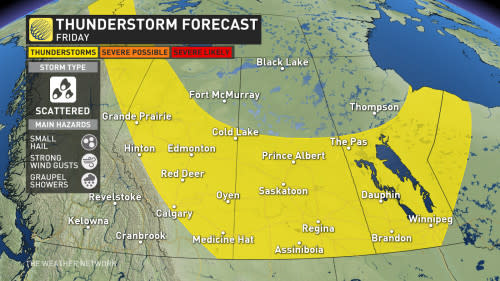
The chance will be toned down, however, when compared to earlier this week. Any thunderstorms that do form should remain below warning criteria and will be scattered in nature.
MUST SEE: How severe weather alerts are issued, and potentially save lives
However, it will still be important to keep an eye on the sky and on any watches and warnings that are issued, as conditions can change quickly when severe weather hits.
Friday: Thunderstorm chance lingers, becomes more scattered

SUMMER 2024: Get an in-depth look at the Summer Forecast, tips to plan for it, and much more!
By Friday, this persistent low will stall over the northern Prairies, extending the unsettled weather pattern for another day.
Strong wind gusts will still be prevalent so small hail and graupel are once again on the table.
The thunderstorm risk will remain over the southern Prairies and parts of northern Alberta. Temperatures will still be on the cooler side but will slowly climb into the weekend.
In addition to the thunderstorm risk, additional rainfall is coming to more vulnerable areas of the Prairies, including the Fort McMurray, Alta., area –– a region that desperately needs the rain amid drought and wildfire conditions.
After an unsettled week for weather, a drier pattern is expected across southern areas during early June, but northern locales should continue to see some much-needed rain.
However, the drier pattern should spread north as we head into the second week of June.
Be sure to check back on the latest forecast information across the Prairies this week

