
'It's time to check on your property': Fort Simpson water levels drop below 10 metres

Water levels in Fort Simpson, N.W.T., dropped to 9.25 metres Sunday morning, and Mayor Sean Whelly said residents are heading back to their properties for the first time since an evacuation order was issued last weekend.
More than 700 people were displaced and evacuated to higher ground or neighbouring communities as water levels grew to new extremes in the community, which rests at the intersection of the Mackenzie and Liard rivers. At one point, the water had swelled as high as 16 metres.
"We're just telling people, go on down, it's time to check on your property and please let us know what damage has occurred," said Whelly.
It's the first time the village has told residents they can go back to the island since water levels swelled as high as 16 metres, although some have made the trip home already, he said.
"We've been receiving anecdotal reports of damages, how much water was in people's basements," said Whelly.
"We're going to ask residents to document everything they see, to report back to us any significant damages to their houses, basements, that type of thing, so we can at least pass that preliminary assessment information into the GNWT [Government of the Northwest Territories]."
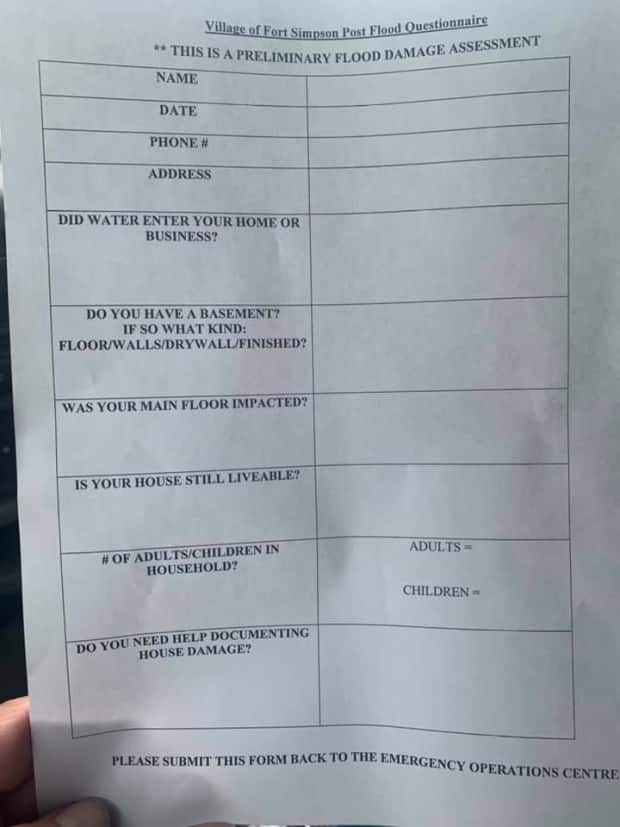
Whelly said the damage has been widespread, and should qualify for the government's Disaster Assistance Policy.
"Many homes had backups in their sewers, basement sewers, coming up the walls … five to six feet of water and sewer up the walls," he said. "Even the Village of Fort Simpson will qualify under that [policy] because we've experienced significant road and infrastructure damages."
Whelly said the N.W.T. Power Corporation would also be going around on Sunday or Monday to turn on power in the main buildings, provided it's safe to do so.
"I'm talking about the rec centre, health centre, maybe the Northern store," he said.
In an update from a spokesperson for the Department of Municipal and Community Affairs (MACA), the government said a total of three flights have been provided out of Fort Simpson — the last one flew to Hay River with 24 people on board, while about 120 residents have been evacuated to Fort Smith.
The federal government said Saturday it had responded to the territory's request for help from the Canadian Armed Forces local Rangers. They will be supporting impacted communities along the Mackenzie River and engaging through local emergency management organizations, said MACA.
Traditional knowledge of the water
Jim Antoine, a non-island resident in Fort Simpson, said the water levels have dropped dramatically because the ice has started to break up further downstream, including in Wrigley.
"It released and opened up the Mackenzie," he said. "We're pretty much in the clear now."
But the flood of 2021 has been the worst he's ever seen.
"I was a young boy, 1963, when we had a big flood here. But the water level this year exceeded that. It was a lot higher," he said.
Antoine shared traditional knowledge about why the water levels were so high this year. He said it can be traced back to high water levels last summer on Great Slave Lake and the Mackenzie River, and an unusual fall break-up.
"When the ice floe was starting to slow down and freezing in front of [Fort] Simpson, something different happened — which was the ice broke last fall, around that time, and cleared the river," he said.
The break up caused jams of ice, said Antoine, and then it froze that way, making parts of the Mackenzie River impassable for hunters and trappers on snow machines throughout the winter.
Because of that, he believes the water behaved different when the Liard River broke up this spring..
"Usually three or four days, normal time, [the Liard River] breaks up the rest of the Mackenzie down from Simpson. But this year, it didn't happen. It broke out, went past Simpson, and it further plugged up the ice jam that happened last fall," he said.
"Then we had this tremendous surge of water that rose to this level and flooded everything," he said. "That's the traditional knowledge we have here about how the Mackenzie froze last fall and why we have such a big flood this year."
