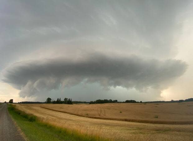
Storms leave trail of damage as tornado watch for London-Middlesex ends

Bringing high winds, rain and unconfirmed tornado reports, a number of severe summer storms made their mark across southwestern Ontario on Wednesday — darkening skies, drenching anyone in their path and damaging some farm structures north of London.
The storms began rolling east from Michigan in the early afternoon, at first bringing heavy rains and winds to areas along the Lake Huron shoreline from near Goderich up to Georgian Bay.
Environment Canada issued, updated and amended multiple warnings and watches for tornadoes and severe thunderstorms as they moved east.
But it was a storm that travelled from Sarnia just before 7 p.m. ET that caused the most damage in the farming community of Thedford, Ont., about 60 kilometres northwest of London.
Images from that area shared with CBC News show limbs ripped from trees, corn stalks flattened in their fields and a few farm structures with extensive roof damage. In one case, a large metal and fabric cover — the kind that can cover a riding corral — lay crumpled and draped over an adjacent barn.
Nick Dewhirst, a Michigan-based storm-chaser who came to photograph the storms, said the damage near Thedford was the worst he saw in a day of driving across the farm country north of London.
"There were a lot of snapped trees in that corridor between Thedford and Arkona," a community some 10 kilometres to the south, he said.

"I drove by a couple of barns with some minor roof damage. There was a lot of bent over corn."
The storm filled the skies north of London with a massive, cascading "mothership" cloud. Dewhirst, who captured a powerful image of it, said such clouds can only form in super cell storms and are more common on the plains of the United States, not the Great Lakes region.
"It was really a treat to see that," he said.
There were unconfirmed tornado reports amid the severe weather. Environment Canada typically makes a determination a few days after a severe summer storm event.
By 9:30 p.m. all of the tornado warnings had ended for southwestern Ontario, while most communities remained under severe thunderstorm watches. Heat alerts in effect since early in the week remained in place with conditions staying hot and muggy.


