
'Ring of Fire' weather pattern slamming Midwest with torrential rain, severe weather
MINNEAPOLIS – A weather pattern known as the "Ring of Fire" is bringing a string of wet, stormy days to the Midwest for the first part of the week due in part to the massive heat dome that’s sending temperatures soaring into the 90s across the Ohio Valley and Northeast.
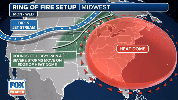
A "Ring of Fire" pattern is when thunderstorm complexes move along the edge of a strong upper-level ridge – in this case, thunderstorms will move along the northern edge of the high-pressure system responsible for the potentially historic heat wave in the eastern U.S.
This type of weather pattern also more commonly occurs during the summer months when the U.S. sees blocking high-pressure systems that cause some of the worst heat waves.
However, the "Ring of Fire" is simply a term, and there’s nothing different about the thunderstorms and rain that develop along the edge of the heat dome. Storms do tend to move a bit faster along the edge of the high pressure.
Here’s a breakdown of the severe weather and flash flood threat this week in the Midwest.
A Severe Thunderstorm Watch was issued for portions of northern Wisconsin and Michigan’s Upper Peninsula that will remain in effect until 4 p.m. CT.
In Wisconsin, the watch includes cities like Wausau, Rhinelander and Oconto. Green Bay is just outside the watch box, but severe weather is still possible there on Monday.
In Michigan, cities like Houghton and Marquette have been included in the Severe Thunderstorm Watch.
Severe thunderstorms will be possible Monday from the central Plains to the Upper Midwest. However, NOAA’s Storm Prediction Center (SPC) has highlighted areas of the region with a higher risk.
More than 7 million people from Nebraska through the Dakotas and into Minnesota, Iowa, Wisconsin and Michigan have been placed in a Level 2 out of 5 risk on the SPC’s severe thunderstorm risk scale.
This includes Fargo in North Dakota, Minneapolis and St. Paul in Minnesota and Sioux Falls in South Dakota.
DOWNLOAD THE FREE FOX WEATHER APP
NOAA’s Weather Prediction Center (WPC) has increased the risk of flash flooding across the Upper Midwest.
Portions of eastern South Dakota and North Dakota, all of Minnesota and much of Wisconsin are in a Level 2 out of 4 risk of flash flooding on Monday.
Flood Watches have been posted in portions of North Dakota, Minnesota and Wisconsin and include Grand Forks and Fargo in North Dakota and International Falls, Duluth, Minneapolis and Albert Lea in Minnesota.
NATIONAL WEATHER SERVICE REVAMPS FLOOD ALERTS
Thunderstorms that develop on Monday will be capable of producing large hail, damaging wind gusts and some tornadoes – although that risk is relatively low.
The severe weather threat on Tuesday will expand a little farther east.
The SPC placed areas of northwestern Iowa, eastern Minnesota and northwestern Wisconsin in a Level 2 out of 5 risk of severe weather.
This risk area includes about 7.5 million people in cities such as Minneapolis and St. Paul in Minnesota. Omaha in Nebraska is also included.
WATCH VS. WARNING: HERE ARE THE DIFFERENCES BETWEEN THESE WEATHER TERMS THAT COULD SAVE YOUR LIFE
The same areas at risk of severe weather Tuesday will also be at risk of flash flooding. However, the threat extends farther south than Monday and includes portions of Nebraska and Kansas.
Cities in the Level 2 out of 4 flash flood risk Tuesday include Duluth and Minneapolis in Minnesota, Des Moines in Iowa and Dodge City in Kansas.
HOW FLOODWATER CAN MAKE YOU VERY SICK
More flash flooding is possible on Wednesday. The WPC has placed a wider area of the Plains and Midwest in a Level 1 out of 4 risk of flash flooding on Wednesday. A slightly higher threat of flooding is expected in portions of eastern Nebraska and western Iowa, where the risk is a Level 2 out of 4.
The FOX Forecast Center expects a widespread area of 3-5 inches of rain through Friday, while some areas may see up to 7 inches locally.
Original article source: 'Ring of Fire' weather pattern slamming Midwest with torrential rain, severe weather
