
When the Triangle can expect wind, rain (and cooler temps) from Hurricane Idalia
Hurricane Idalia made landfall in Florida Wednesday morning as a Category 3 hurricane, bringing deadly storm surge and 125 mph wind. The storm has since weakened to a Category 1 hurricane, but it is still expected to impact North Carolina’s coast and inland areas.
Here’s how the Triangle and central parts of North Carolina could feel the effects of Idalia.
The National Weather Service Raleigh put a hazardous weather outlook in place for the central part of the state, forecasting strong winds and heavy rain Wednesday and Thursday.
This story reflects the NWS Raleigh forecast as of noon Wednesday.
We will continue to update this story as more information becomes available from the National Weather Service and the National Hurricane Center.
Wednesday’s forecast in Raleigh, Durham from Hurricane Idalia
Idalia will move up the Carolina coast late Wednesday into Thursday, NWS Raleigh reports.
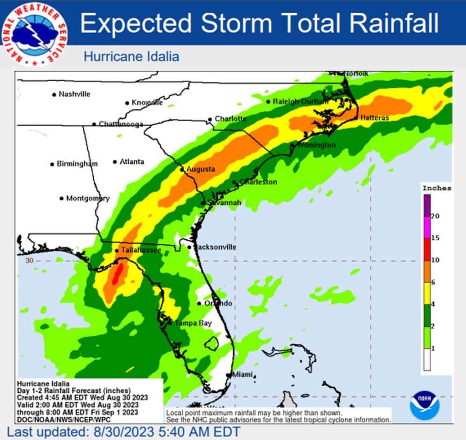
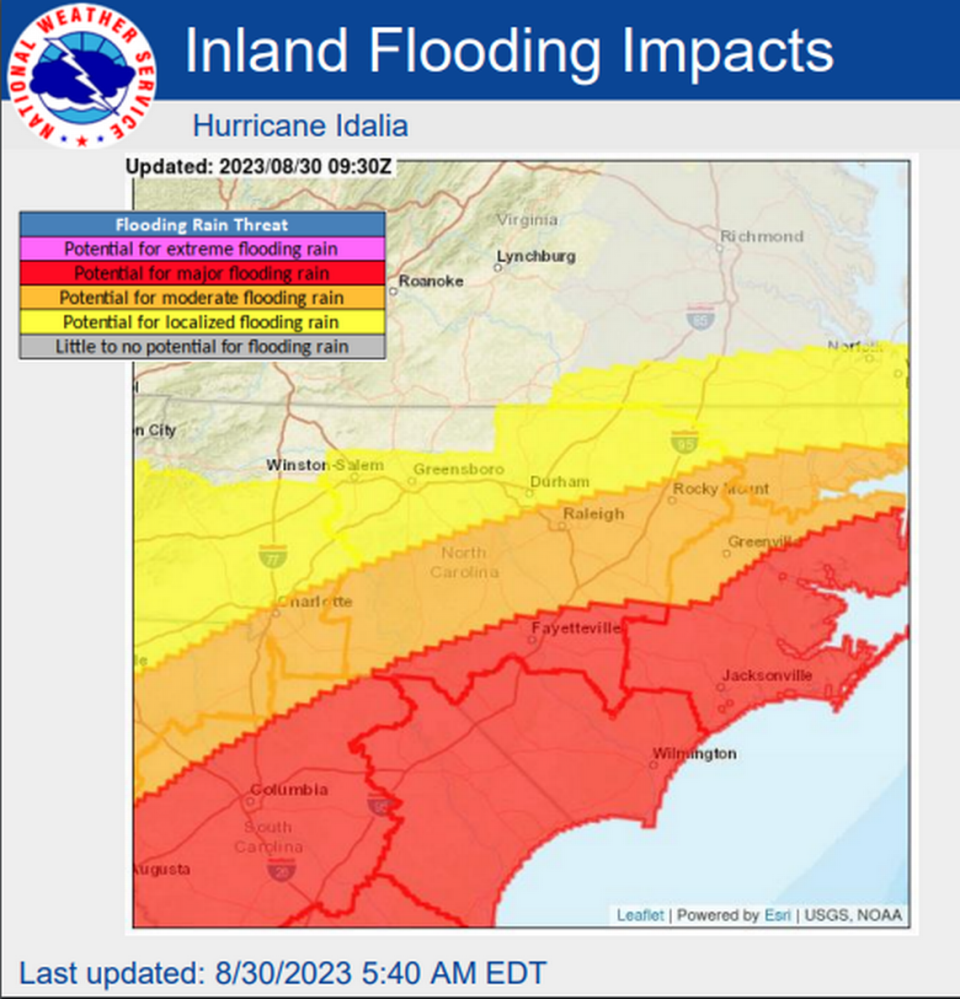
The southern coastal plains counties will get the worst of the storm, seeing up to 6 inches of rain and hazardous wind conditions.
1200 pm: The latest advisory from the @NHC_Atlantic was recently issued. You can stay up to date at https://t.co/s7vBw1g7Sc. #Idalia pic.twitter.com/pnP7an5JAZ
— NWS Raleigh (@NWSRaleigh) August 30, 2023
In the Raleigh area:
▪ Rain: Expected to get 1-2 inches of rain from Wednesday afternoon to Thursday evening.
Rain will progressively get heavier as it creeps into central North Carolina, beginning slowly in the afternoon and getting to its heaviest Wednesday evening.
1105 am: Light rain on the northern fringes of #Idalia are spreading across SC and into the coastal areas of NC. Rain will spread north into central NC this afternoon and early evening. Steadier rain will arrive after dark with the rain becoming heavy at times by late evening. pic.twitter.com/9WCQvWNGkE
— NWS Raleigh (@NWSRaleigh) August 30, 2023
▪ Wind: Gusty winds of 20 to 30 mph. Isolated gusts to 45 mph.
There is a 5-10% chance of tropical storm force winds across southeastern portions of central North Carolina. The earliest reasonable time of arrival is early Wednesday evening.
▪ Flooding: Because of the “excessive rainfall,” flooding continues to be possible. But this is a much larger threat in the southern coastal plain counties.
Raleigh weather forecast for Wednesday, Thursday
▪ Wednesday: A chance of showers and thunderstorms, then showers likely and possibly a thunderstorm after 5 p.m. Some of the storms could produce heavy rain.
Cloudy, with a high near 84.
Southwest wind around 6 mph.
Chance of precipitation is 60%. New rainfall amounts of less than a tenth of an inch, except higher amounts possible in thunderstorms.
▪ Wednesday night: Showers and possibly a thunderstorm. Some of the storms could produce heavy rain.
Low around 65.
Breezy, with a light east wind becoming northeast 15 to 20 mph in the evening. Winds could gust as high as 30 mph.
Chance of precipitation is 100%. New rainfall amounts between three quarters and one inch possible.
▪ Thursday: Showers, mainly before 2 p.m.
High near 71.
Breezy, with a north wind 15 to 24 mph, with gusts as high as 36 mph.
Chance of precipitation is 80%. New precipitation amounts between a quarter and half of an inch possible.
▪ Thursday night: Partly cloudy, with a low around 60. North wind around 9 mph.
(Source: weather.gov/rah as of 12 p.m. Wednesday)
Our greatest concern with #Idalia is with heavy rain. Storm totals of 2-5 inches are expected south/east of Raleigh with localized amounts in excess of 6 inches. This may result in flash flooding. River flooding is also possible and can be monitored at https://t.co/bdUXQ47Vms pic.twitter.com/KmConXibKH
— NWS Raleigh (@NWSRaleigh) August 30, 2023
