
Tropical Storm Beryl forms in Atlantic, could be hurricane by Saturday night
Tropical Storm Beryl formed Friday evening in the Atlantic east of the Windward Islands and is expected to become a "dangerous major" hurricane by Monday, the National Hurricane Center said.
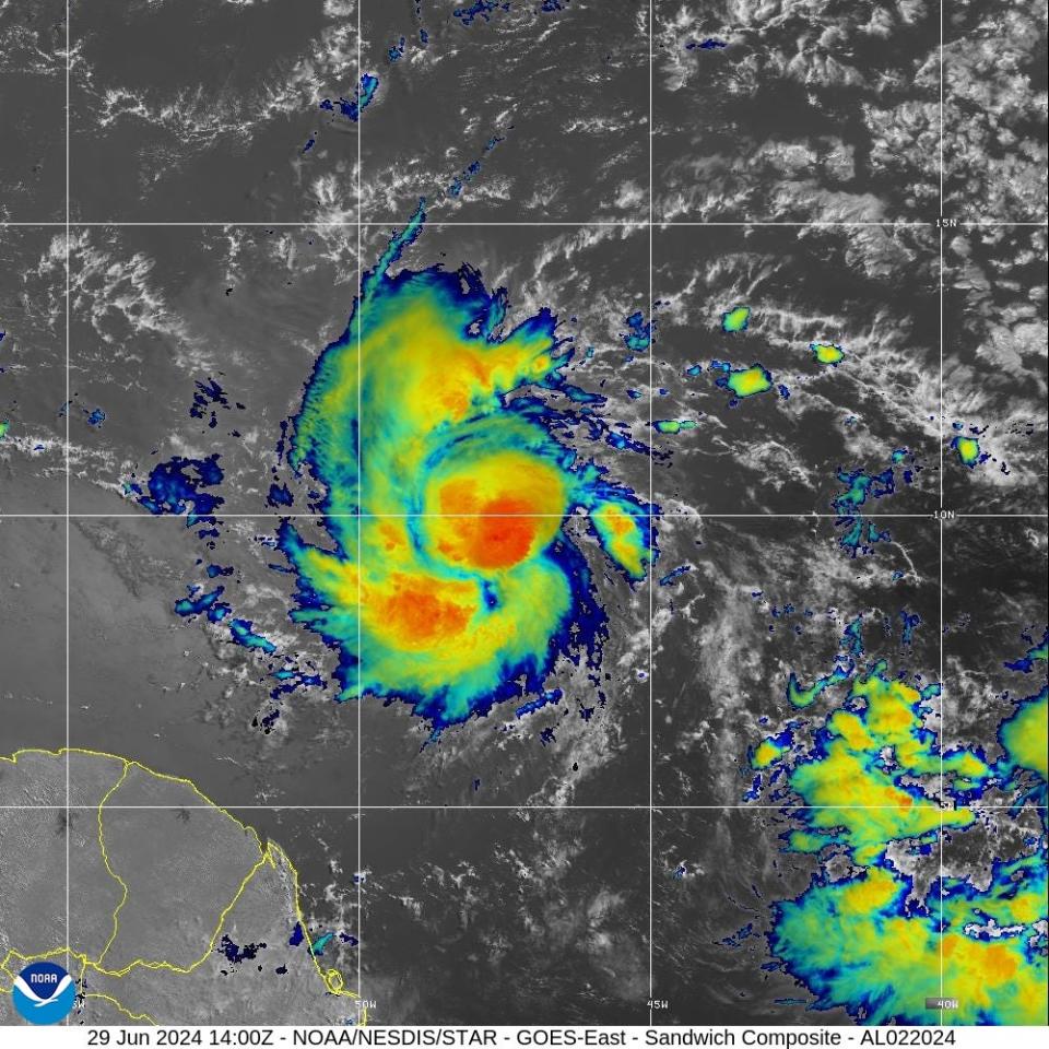
The second named storm of the 2024 Atlantic hurricane season, is expected to become Hurricane Beryl by Saturday night or Sunday morning as it moves westward. It formally turned into a tropical storm on Friday about 1,100 miles southeast of the Windward Islands at the eastern end of the Caribbean.
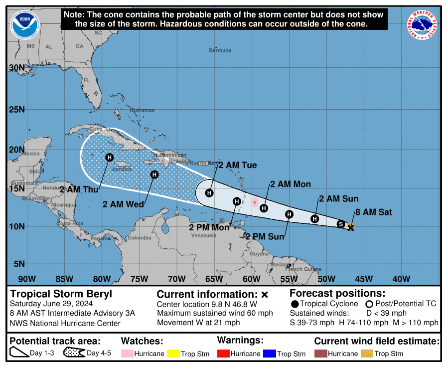
Beryl was moving about 23 mph, with maximum sustained winds of 65 mph, according to the hurricane center's 11 a.m. advisory Saturday.
Tropical Storm Beryl to become 'dangerous major' hurricane
The hurricane center predicts Beryl will become a hurricane by late Saturday or early Sunday and rapidly strengthen further, with its winds reaching major hurricane strength with winds of 111 mph or more before its center reaches the Windward Islands on Monday morning.
Conditions in the atmosphere and ocean where Beryl is moving are “abnormally favorable for strengthening,” the center has said.
Conditions appear less conducive after the storm enters the Caribbean. It could encounter winds that disrupt its cloud structure and prevent it from strengthening, the center said this morning.
The storm is 820 miles east-southeast of Barbados, according to the advisory. Tropical storm force winds are expected to extend 45 miles outward from the center.
The storm could bring heavy rain, hurricane-force winds and dangerous storm surges and waves as it crosses over the Windward Islands Sunday night and into Monday. A hurricane watch was issued for Barbados and others "will likely be required" later Saturday as the system moves further into the Lesser Antilles, which includes the Windward Islands, Leeward Islands and Leeward Antilles.
Barbados and nearby islands could receive 3 to 6 inches of rain, with localized flooding in vulnerable areas and life-threatening surf and rip currents.
What's the forecast for Beryl?
People in the central and western Caribbean should monitor the storm's progress, keeping in mind that the margin of error for the forecast at four or five days out can be quite large, the center advised.
By Sunday evening, when Beryl moves into the Caribbean Sea, the official forecast states its winds could be up to 105 mph. Atmospheric conditions are typically not favorable for strengthening storms at this point in June, however, some computer models are “quite aggressive,” and suggest the storm could be a major hurricane before it reaches the Windwards, according to the center’s forecast discussion.
Once the storm crosses into the Caribbean, the forecast models aren’t yet in agreement on the storm’s potential path, the center said. For now, the official forecast cone shows the center of the hurricane could be near or over the western half of the Dominican Republic and Haiti on Tuesday evening and over Jamaica or eastern Cuba on Wednesday evening.
How unusual is a storm like Beryl?
The hurricane center said only a few storms in history have formed over the central or eastern tropical Atlantic this early in the year.
If it becomes a hurricane by Sunday afternoon, it would be the farthest east on record a hurricane has formed in the tropical Atlantic, breaking the record set in 1933, said Phil Klotzbach, a senior research scientist at Colorado State University, and lead author of its seasonal hurricane outlook.
While tropical cyclone activity before August 1 has little correlation with the overall activity in a season, early season activity east of the Lesser Antilles is generally associated with very busy seasons, Klotzbach posted on X.
The new storm comes a week after Tropical Storm Alberto pummeled northeastern Mexico, triggering major floods and killing at least four people, including three children. The storm also drenched the Gulf Coast of Texas, leaving Surfside Beach, a coastal city south of Houston, under several feet of water.
System moving toward Gulf of Mexico, tropical wave in the Atlantic
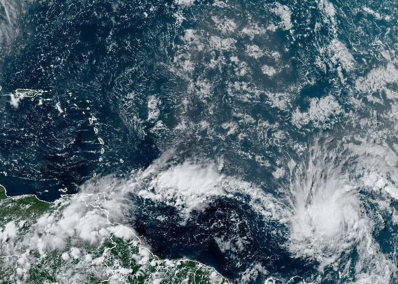
A low-pressure system closer to the U.S. is expected to develop further as it moves over the Bay of Campeche Saturday night into Sunday. The center predicts a tropical depression to form before the system reaches Mexico. The center listed the storm's chances of further development over the next 48 hours at 40%.
Regardless of development, the system is forecast to spread rain and gusty winds across portions of Central America and Mexico through the weekend.
In the Atlantic, a tropical wave centered several hundred miles southwest of the Cabo Verde Islands is forming showers and thunderstorms. The system could develop next week as it heads west at 15 to 20 mph. That system has a 60% chance of additional development over the next seven days.
More: List of 2024 Atlantic hurricane season storm names starts with Alberto and Beryl
Experts predict a busy hurricane season
Beryl is the latest storm to emerge in what's expected to be an above-average season for tropical storms and hurricanes.
In May, the National Oceanic and Atmospheric Administration predicted between 17 and 25 named storms would form this Atlantic hurricane season – the most storms NOAA has forecast in a preseason outlook. Eight to 18 of the storms are forecast to develop into hurricanes, with four to seven being major hurricanes (Category 3, 4 or 5; with winds of 111 mph or higher), according to NOAA.
"All the ingredients are in place for an active season," said National Weather Service Director Ken Graham at a news conference in May. NOAA Director Rick Spinrad said the Atlantic hurricane season is shaping up to be "extraordinary," with an 85% chance for an above-average year.
The record for most named storms in a season is 30, set in 2020. A typical year averages about 14 tropical storms, seven of which spin into hurricanes, based on weather records from 1991 to 2020.
Contributing: Doyle Rice, Gabe Hauari, USA TODAY; Cheryl McCloud, USA TODAY Network-Florida
This article originally appeared on USA TODAY: Tropical Storm Beryl forms in Atlantic, could become hurricane

