
Hurricane Beryl, now an ‘extremely dangerous’ Category 4 storm, heads for the Caribbean
About 40 minutes after the National Hurricane Center released its 11 a.m. Hurricane Beryl advisory Sunday, the hurricane center had an update — as predicted, Beryl had strengthened into Category 4 hurricane.
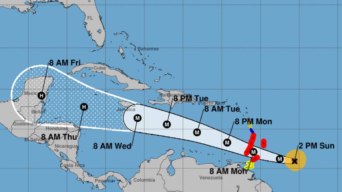
Here’s the latest from the National Hurricane Center’s Sunday’s 2 p.m. advisory.
Beryl’s wind speed: Beryl’s packing 130 mph sustained winds, an increase of 50 mph from Saturday’s 8 p.m. advisory and 10 mph from Sunday’s 11 a.m. advisory. Higher gusts are present. Hurricane force winds blow up to 30 miles from Beryl’s center, with tropical storm force winds extending 115 miles.
“(National Oceanic and Atmospheric Administration) and Air Force Reserve hurricane hunter aircraft data indicate that Beryl has strengthened to an extremely dangerous Category 4 hurricane,” the hurricane center said.
Where Beryl is and where Beryl is going: The storm is about 310 miles east-southeast of Barbados and 405 miles east of Grenada. It’s moving west at 21 mph, swift for a storm.
“A continued quick westward to west-northwestward motion is expected during the next few days,” the hurricane center said. “On the forecast track, the center of Beryl is expected to move across the Windward Islands Monday morning and across the southeastern and central Caribbean Sea late Monday through Wednesday.”
Alerts: Tobago, Barbados, St. Lucia, Grenada, St. Vincent and the Grenadine Islands under a hurricane warning. Martinique is under a tropical storm warning. Trinidad and Dominca are under a tropical storm watch
The rest of the Lesser Antilles, Haiti, the Dominican Republic, Jamaica, the Cayman Islands and the remainder of the northwestern Caribbean “should closely monitor the progress of Beryl. Additional watches and warnings will likely be required for portions of this area later Sunday.”
Hazards: A “life-threatening storm surge” of 6 to 9 feet could hit the hurricane warning areas. Barbados and the Windward Islands could deal with 3 to 6 inches of rain today and Monday with accompanying flooding. Puerto Rico may also see 1 to 4 inches of rain over its southeastern region. Deadly surf and rip current conditions will preclude water activities in the Windward and southern Leeward Islands.
Next Advisory: There will be a full advisory at 5 p.m.
Caribbean preparations
At 8:30 p.m. Sunday, Barbados and Saint Lucia will go into nationwide shutdowns. The Caribbean Community regional economic group CARICOM canceled a gathering in Grenada of leaders from its 15 members scheduled for Wednesday through Friday.
St. Lucia Prime Minister Keith Mitchell advised his citizens to prepare and pray. All stable patients at the Owen King European Union Hospital will be discharged Sunday.
More on Beryl
Where Hurricane Beryl formed Saturday is the farthest east for a June hurricane in historical record. Only one other hurricane has formed anywhere nearby in June, and that was in 1933.
#Beryl is now a #hurricane - the farthest east that a hurricane has formed in the tropical Atlantic (<=23.5°N) in June on record, breaking the old record set in 1933. pic.twitter.com/ah9pow2G9a
— Philip Klotzbach (@philklotzbach) June 29, 2024
By Tuesday, the hurricane center noted that conditions could shift, and a strong subtropical ridge that is expected to keep the storm at lower latitudes could lighten, allowing Beryl to inch up into higher latitudes. Additional wind shear could help batter it back down a category or two.
Right behind Beryl, forecasters also are watching another system. This one, a tropical wave hundreds of miles southwest of the Cabo Verde Islands, had a growing shot at forming into a tropical depression or storm within the week.
As of the 8 a.m. update, forecasters gave it a 40% chance of strengthening into a depression over the next two days and a 70% chance in the next seven days.

