Climate change is making tropical storms and hurricanes stronger, slower, and wetter
Morgan McFall-Johnsen,Jessica Orwig
·6 min read
Climate change is making tropical storms and hurricanes stronger, slower, and wetter
Hurricane Idalia is forecast to bring "life-threatening" winds and storm surge to Florida on Wednesday.
Rising temperatures in the atmosphere and ocean are making hurricanes stronger, slower, and wetter.
Tropical storms strengthen in warm waters, and warm air holds more moisture.
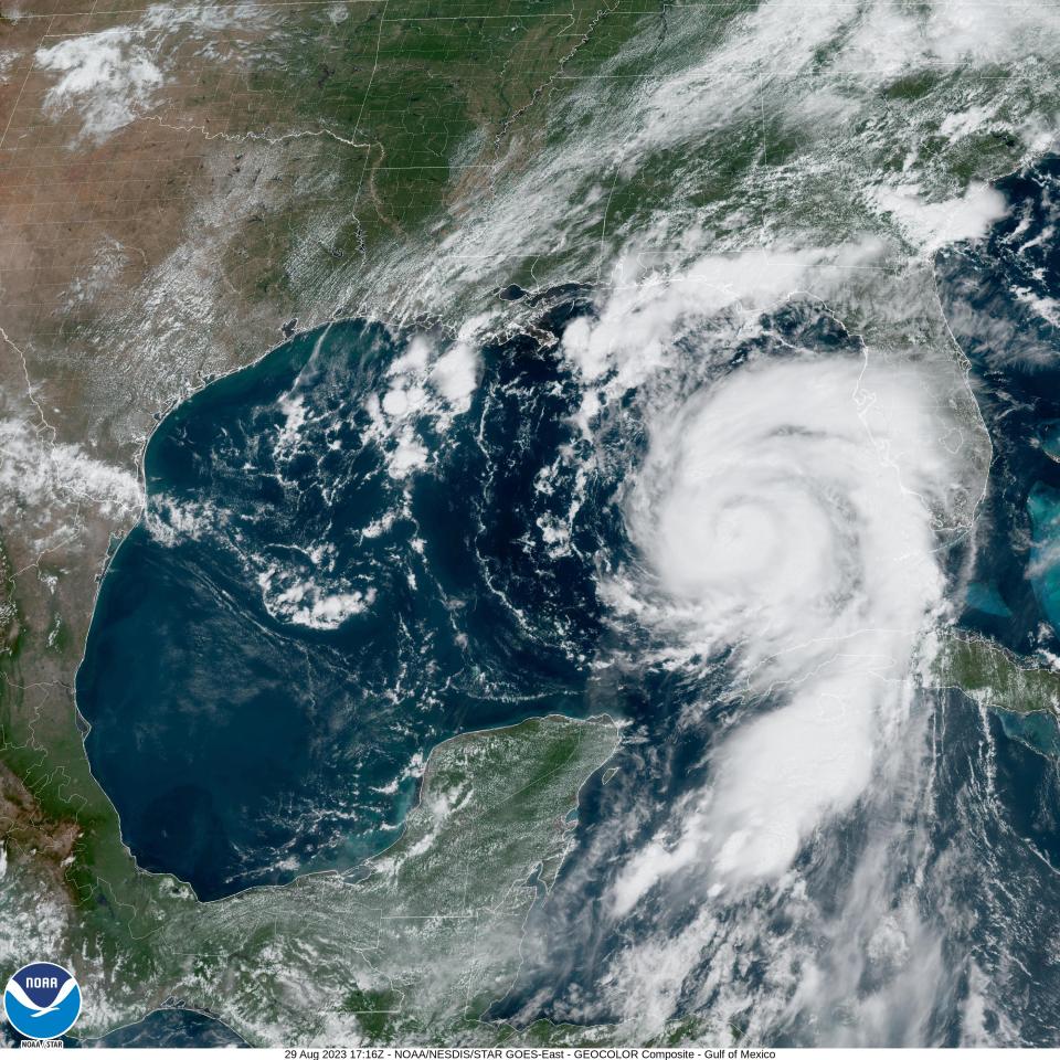
Hurricane Idalia has intensified rapidly and is projected to swell to a Category 3 hurricane on Wednesday morning.
Scientists can't definitively say whether climate change caused any single storm without conducting further analysis, but overall, warming makes hurricanes more devastating than they would otherwise be.
Hurricane Idalia is seen barreling toward Florida as a Category 1 storm on Tuesday.NASA/GOES-East
That's because higher water temperatures lead to sea-level rise, which increases the flooding from storm surges. Warmer air also holds more atmospheric water vapor, which enables tropical storms to strengthen and unleash more precipitation.
Here's what to know about why storms are getting so much stronger, wetter, and slower.
How a hurricane forms
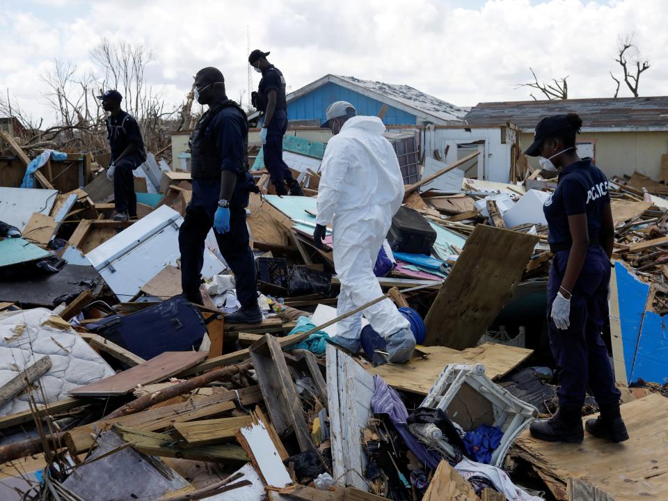
Police officers search for the dead in the destroyed Mudd neighborhood after Hurricane Dorian hit the Abaco Islands in the Bahamas.Reuters
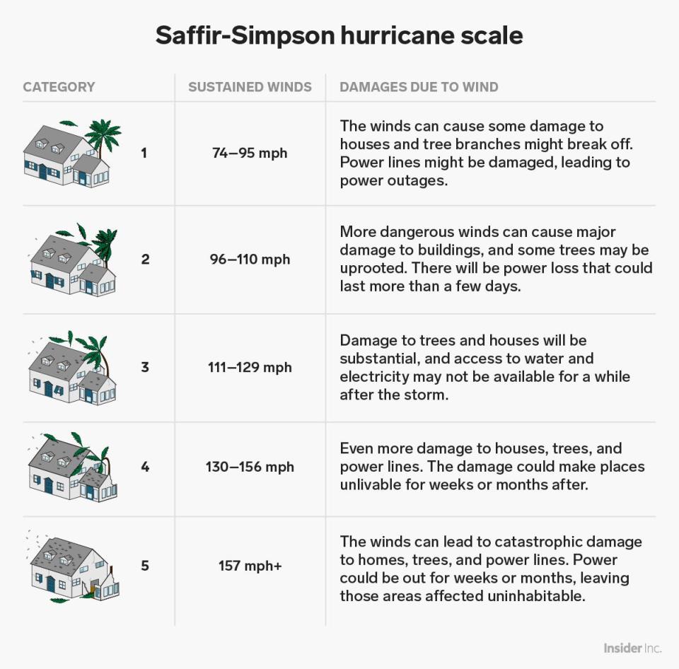
Hurricanes are vast, low-pressure tropical cyclones with wind speeds over 74 mph.
In the Atlantic Ocean, the hurricane season generally runs from June through November, with storm activity peaking around September 10.
On average, the NHC says the Atlantic sees seven hurricanes during a season, with three of them developing into major hurricanes.
As warm moisture rises, it releases energy, forming thunderstorms. As more thunderstorms form, the winds spiral upward and outward, creating a vortex. Clouds then form in the upper atmosphere as the warm air condenses.
Shayanne Gal/Business Insider
As the winds churn, an area of low pressure forms over the ocean's surface. At this point, hurricanes need low wind shear — or a lack of prevailing wind — to form the cyclonic shape associated with a hurricane.
Cyclones start out as tropical depressions, with sustained wind speeds below 39 mph. As winds pick up and pass that threshold, the cyclone becomes a tropical storm. Once the wind speed hits 74 mph, the storm is considered a Category 1 hurricane on the Saffir-Simpson scale.
Samantha Lee/Business Insider
The National Oceanic and Atmospheric Administration (NOAA) projected a 60% chance that the 2023 Atlantic hurricane season would see above-normal activity.
NOAA projects that before the end of the hurricane season in November, we'll likely see 14-21 storms with at least 39 mph wind speeds, with six to 11 of those becoming major hurricanes with wind speeds of 74 mph or greater.
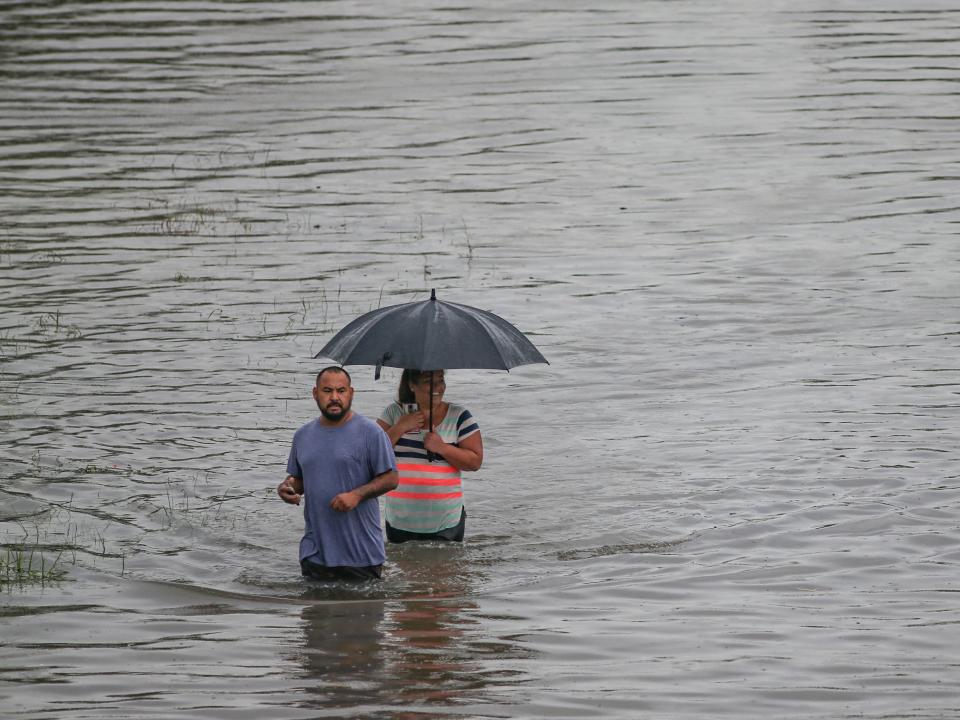
Hurricanes are moving more slowly and dropping more rain
People walk the floodwaters from Tropical Storm Imelda on September 19, 2019 in Houston, Texas.Thomas B. Shea/Getty Images
Hurricanes use warm water as fuel, so once a hurricane moves over colder water or dry land, it usually weakens and dissipates.
However, because climate change is causing ocean and air temperatures to climb — summer 2023 is shaping up to be the hottest summer on record — hurricanes are getting wetter and more sluggish.
Over the past 70 years or so, the speed of hurricanes and tropical storms has slowed about 10% on average, according to a 2018 study.
Over land in the North Atlantic and Western North Pacific specifically, storms are moving 20% to 30% more slowly, the study showed.
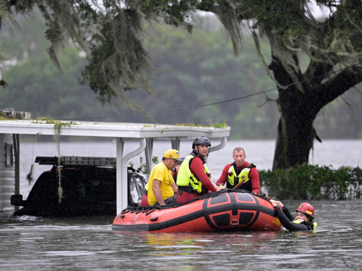
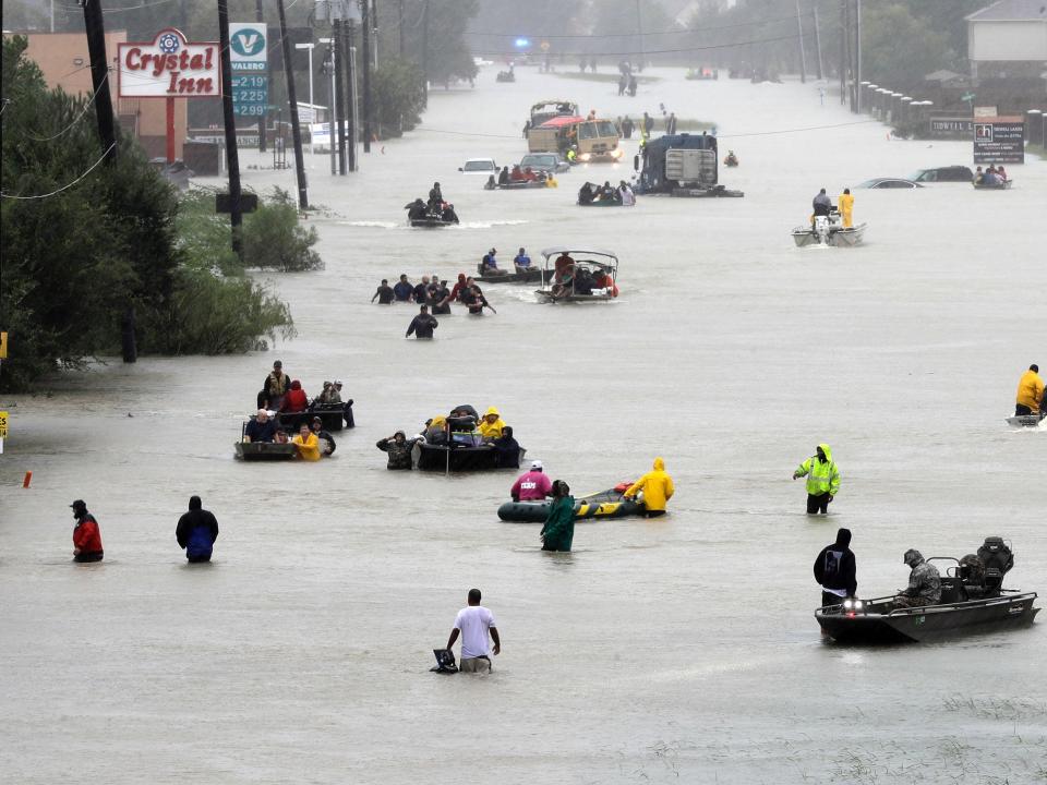
Houston residents navigate streets in boats due to flooding during Hurricane Harvey.David J. Phillip/AP
A slower pace of movement gives a storm more time to lash an area with powerful winds and dump rain, which can exacerbate flood problems. So its effects can wind up feeling more intense.
Hurricane Harvey in 2017 was a prime example of this: After it made landfall, Harvey weakened to a tropical storm, then stalled for days. That allowed the storm to dump unprecedented amounts of rain on the Houston area — scientist Tom Di Liberto described it as the storm that "refused to leave."
Climate scientist Michael Mann wrote on Facebook in 2017 that Hurricane Harvey — which flooded Houston, killed more than 100 people, and caused $125 billion in damages — "was almost certainly more intense than it would have been in the absence of human-caused warming, which means stronger winds, more wind damage, and a larger storm surge."
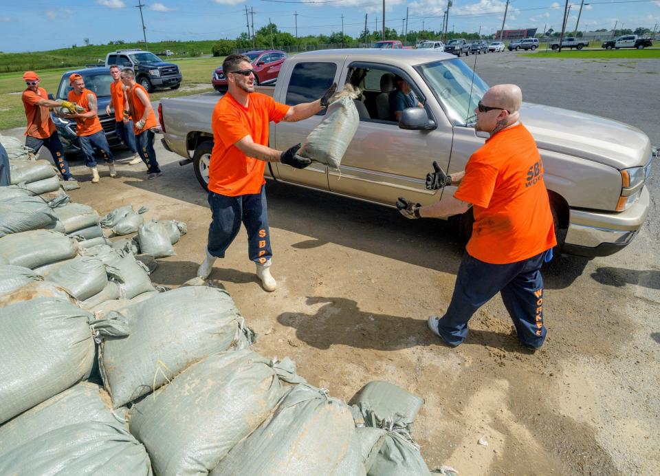
St. Bernard Parish Sheriff's Office inmate workers move free sandbags for residents in Chalmette, Louisiana, July 11, 2019 ahead of Hurricane Barry.Associated Press
To make matters worse, a warmer atmosphere can hold more moisture, so a 10% slowdown in a storm's pace could double the amount of rainfall and flooding that an area experiences, James Kossin, a tropical cyclone expert, told Stormwater Report in 2018.
"Precipitation responds to global warming by increasing," Angeline Pendergrass, a project scientist at the University Corporation for Atmospheric Research at the time, said in 2018.
Storms are also getting stronger
A hurricane as seen from space.Flickr/NASA's Marshall Space Flight Center
As ocean temperatures continue to increase, we're also likely to see more severe hurricanes because a storm's wind speed is influenced by the temperature of the water below.
"With warmer oceans caused by global warming, we can expect the strongest storms to get stronger," James Elsner, an atmospheric scientist at Florida State University, told Yale in 2016.
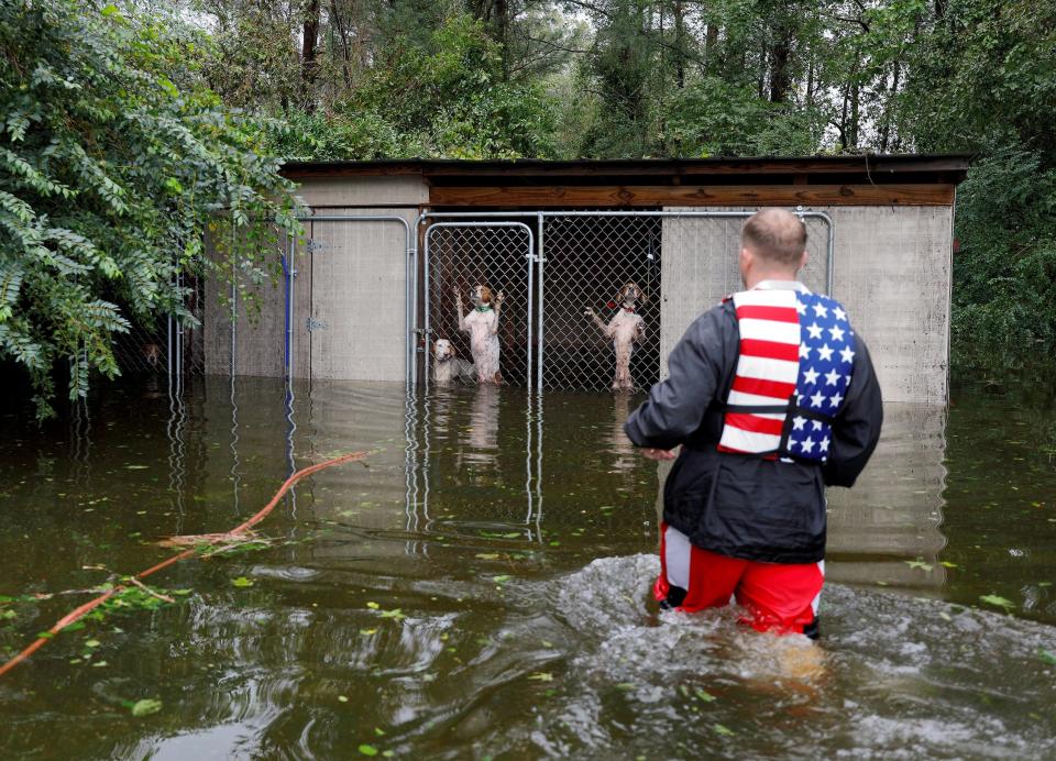
Panicked dogs, left behind by an owner who fled rising flood waters due to Hurricane Florence, are rescued by volunteer Ryan Nichols of Longview, Texas, in Leland, North Carolina, September 16, 2018.Jonathan Drake/Reuters
Generally, a strong storm brings a storm surge: an abnormal rise of water above the predicted tide level. This wall of water can flood coastal communities — if a storm's winds are blowing directly toward the shore and the tide is high, storm surges can force water levels to rise as rapidly as a few feet per minute.
Higher sea levels, of course, lead to more destructive storm surges during a hurricane. Such surges are likely to become a more regular threat, since even if we were to cut emissions dramatically starting today, some sea-level rise is inevitable.
The planet's oceans absorb more than 90% of the extra heat that greenhouse gases trap in the atmosphere, and water (like most things) expands when it's heated.
This story has been updated. It was originally published on September 30, 2022. Aylin Woodward, Kevin Loria, and Jeremy Berke contributed to an earlier version of this story.
Ana Navarro, a long-time co-host of The View, posted on her Instagram Thursday an old photo of nude Melania Trump as a way to troll her husband’s supporters, saying: “You wanna go low? ... I’ll happily go 20,000 leagues under the sea.”It was a picture from 2000 featured in British GQ, five years before Donald Trump married her.Navarro also included a picture of both Trumps partying with Jeffrey Epstein and Ghislaine Maxwell, also from 2000. Her explanation for posting these images was that it wa
FBI Director Christopher Wray revealed during a marathon testimony on Wednesday that investigators still do not know if former President Donald Trump was grazed by a bullet or a piece of shrapnel during his attempted assassination.Twice during the hours-long session, Wray told lawmakers that the FBI was still working to determine what exactly struck the former president on his right ear during a rally in Butler, Pennsylvania. “My understanding is that either it [a bullet] or some shrapnel is wha
Céline Dion and Lady Gaga are performing a duet at the 2024 Paris Olympics opening ceremony. Here's how much they are reportedly being paid for one song.
Donald Trump ditched his ear bandage for his meeting with Israeli Prime Minister Benjamin Netanyahu on Friday. The former president’s right ear returned to public life after being injured during the assassination attempt on the former president on July 13.The former president’s large bandage became an impromptu fashion statement during the Republican National Convention with some attendees donning DIY wound dressings. Following the convention, Trump swapped out his bulky white gauze for a thin n
Kamala Harris’ campaign trolled Donald Trump after his appearance on Fox News Thursday morning with a statement attacking his age and criminal conviction.The Republican gave his two-cents to Fox & Friends on a range of issues over the course of a roughly 30-minute interview, variously describing President Joe Biden as a “problemmed man” and slamming Harris as “real garbage.” Harris for President quickly hit back, releasing a: “Statement on a 78-Year-Old Criminal’s Fox News Appearance.”“After wat
Prince Harry has revealed the terrifying reason he won't bring his wife the Duchess of Sussex, to the UK, in a shocking new interview. Find out more here...