
Disturbance off coast could prompt more showers as waterlogged South Florida recovers
National Hurricane Center forecasters are watching two disturbances that have the potential to morph into a tropical depression this week, although the projections suggest only one of them could impact Florida’s east coast.
But fret not, South Florida: there’s not much to worry about, despite the waterlogged region being hammered by torrential rains over the past five days, said Chris Fisher, a meteorologist at the National Weather Service in Miami.
The region, he added, could see more rain — and breezier conditions along the coast. The increased rain chances in the middle and the end of the week don’t pose a greater threat than any other typical summer storm.
Cities in Broward and Miami-Dade, however, could be hit with floods and other phenomena associated with heavy rain. The deluge of rainfall last week resulted in severe flooding that led authorities to close parts of southbound Interstate 95 near the Fort Lauderdale-Hollywood International Airport. Hundreds of flights were delayed at airports in Fort Lauderdale and Miami, and roads and intersections became impassable in Aventura, Sunny Isles Beach, Hollywood, Miami Beach, Fort Lauderdale, and other parts of South Florida.
READ MORE: South Florida has been hit by dangerous rainfall. Here’s what it looks like
“At this point, it’s nothing we’re really concerned about,” Fisher said. “Keep an eye on the forecast in the coming days.”
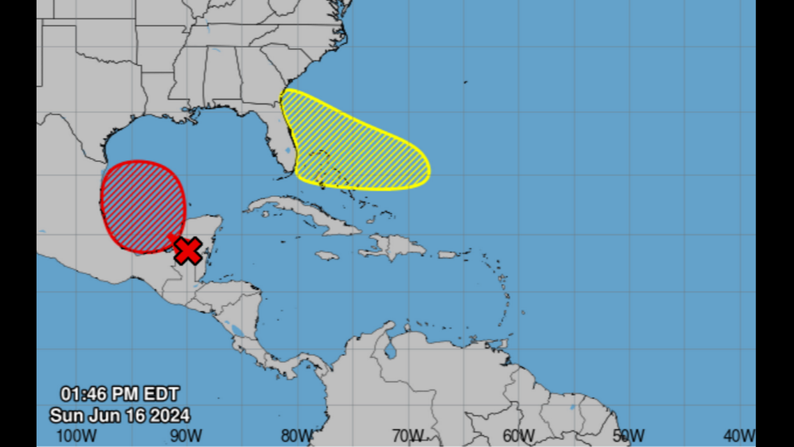
Disturbance No. 2, the one near Florida
In its 8 p.m. tropical weather update, the National Hurricane Center said: “A trough or an area of low pressure is forecast to form a few hundred miles northeast of the central Bahamas in a couple of days. Environmental conditions could be conducive for some development of this system thereafter while it moves westward or west- northwestward.”
Forecast chance of formation in the next two days: near zero.
Forecast chance of formation in the next seven days: 30%.
Disturbance No. 1, the one near Mexico
A big disturbance sits over Central America, the northwestern Caribbean Sea and Mexico’s Yucatan Peninsula. Look for things to start happening Monday or Tuesday.
“Environmental conditions appear conducive for subsequent gradual development of the low, and a tropical depression or tropical storm could form by midweek while it moves slowly westward or west-northwestward,” the NHC said.
Even if it doesn’t develop into a depression or storm, “several days of heavy rainfall are expected across portions of southern Mexico and Central America, and these rains are likely to cause life-threatening flooding and flash flooding.”
Forecast chance of formation in the next two days: 50%
Forecast chance of formation in the next seven days: 70%.

