
UK weather: Ominous funnel clouds spotted as nation is battered by downpours
An unusual weather phenomenon resembling a tornado has been spotted across the UK as the nation was battered by thunderstorms on Thursday.
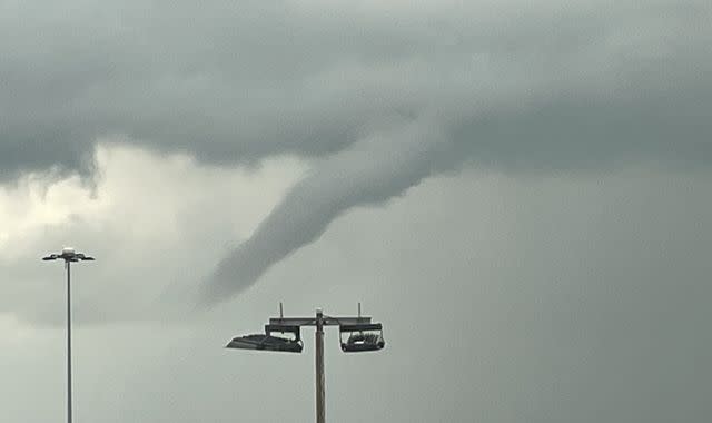
Weather watchers shared sightings of funnel clouds - described by the Met Office as "extended, spinning fingers of cloud".
UK weather - check your forecast here
They reach towards the ground but crucially, never touch it - differentiating them from a tornado.
Funnel clouds were spotted in northern England and the Midlands, including hovering above Humberside Airport and looming over south Lincolnshire, as well as Bedfordshire and Peterborough.
Others spotted funnel clouds in the South East above Deal and Sandwich in Kent, as well as Basingstoke in Hampshire.
Explaining the phenomenon, Sky News weather producer Joanna Robinson said: "Funnel clouds are rotating columns of air that display a cone shape extending towards the ground from the base of a much larger cloud, often a cumulonimbus.
"In the UK they look a bit like a finger in the sky or a dangling piece of rope.
"They only become a tornado once they reach the ground, or a waterspout if they reach water.
"They have been spotted over the last few days, particularly across eastern parts of England today.
"It's not that unusual to see funnel clouds in showery set ups like this and on average the UK sees 35 tornadoes a year, but they are usually weak and cause little or no damage."
The US witnesses more powerful tornadoes and is expecting severe storms in the next few days, with the states of Oklahoma and Kansas particularly vulnerable to the extreme conditions.
Read more:
Tornado kills 26 as it tears through southern US states
Risk of severe weather 'getting worse and worse' after deadly storm hits Mississippi
Rare snow tornado spotted on Shetland Islands in Scotland
The sightings in the UK followed the Met Office issuing a yellow warning for thunderstorms across large parts of the UK until 7pm on Thursday.
The forecaster said showers and a risk of thunder will continue throughout the early evening, potentially causing difficult travel conditions.
However, the wet weather will give way to drier but cloudier skies on Friday, before drier, brighter and warmer conditions are expected on Saturday, when temperatures could reach highs of 20C (68F).

