
Watch out for weekend rain and storms across Ontario and Quebec
Clouds, showers, and occasional thunderstorms—stop us if you’ve heard this one before. The jammed-up jet stream blanketing Canada this weekend will keep conditions unsettled for much of Ontario and Quebec over the next couple of days.
Instability and lift beneath a series of disturbances tracking across the Great Lakes will keep the risk for precipitation and rumbles of thunder in the forecast heading into Saturday and Sunday.
Great news is on the horizon if you’re tired of the gloomy weather. A pattern change arriving next week will offer calmer skies and warmer temperatures across the region.
DON’T MISS: Weekend may feel disappointing in southern Ontario, but the hot weather is near

The rain won't be enough to quench a growing forest fire threat in Quebec.
Be sure to stay up-to-date on all of the weather alerts in your area, especially with the growing thunderstorm chances as we inch even closer to the official start of summer this month.
Through the weekend: Rain persists with unsettled conditions
A pesky upper-level low lingering over the Great Lakes has dictated our foul weather over the past few days, which included a possible tornado in eastern Ontario on Thursday.
There’s no shortage of disturbances where that came from—a series of systems will move over the Great Lakes through the end of the weekend, reinforcing our unsettled pattern for a few days yet.
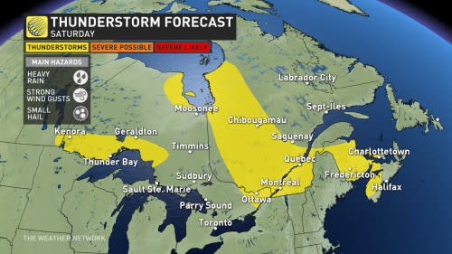
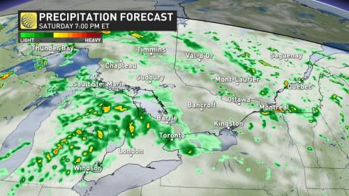
We may start the weekend with rumbles of thunder across eastern Ontario and much of Quebec as instability builds through the day on Saturday. Thunderstorms are also possible along the Trans-Canada Highway in northwestern Ontario.
While Saturday’s storms should remain below severe limits, watch out for the potential for heavy rainfall, strong wind gusts, and small hail in any of the feistier cells that bubble up.
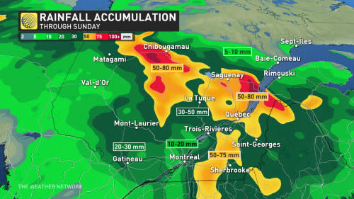
The bulk of the heavy rainfall will focus on Quebec through the end of the weekend, with widespread totals of 50-80 mm on tap for central and eastern portions of the province, including Saguenay and Quebec City. Some areas could see more than 80 mm of rain through Sunday.
Heavy rain will make localized flooding a continuing risk this weekend, but the heavy rain is a welcome sight for regions of Quebec vulnerable to wildfires.
Temperatures will likely remain a few degrees below seasonal across southern and eastern Ontario on Saturday, with James Bay claiming the province’s hot spot as temperatures soar into the low- to mid-20s outside of the influence of this gloomy trough.
Forecasters expect the unsettled pattern to linger over southern Quebec into next week as well. While we’ll see rain-free periods and even some peeks of sunshine, temperatures will remain a few degrees below seasonal and some areas may even struggle to top 20 degrees beneath the thicker clouds.
Conditions will remain cooler for the second half of next week, lasting into Father's Day weekend. A warmer pattern will return during late June.
Be sure to check back for the latest weather updates across Ontario and Quebec.

