
Weekend washout: Relentless rain, thunderstorms to drench South


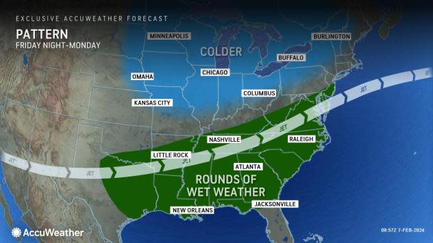
The ongoing break from wet weather and clouds in the Southeast will soon come to a close. Between late in the week and the start of this weekend, a stormy pattern will return with rounds of rain expected to soak the region, AccuWeather forecasters say.
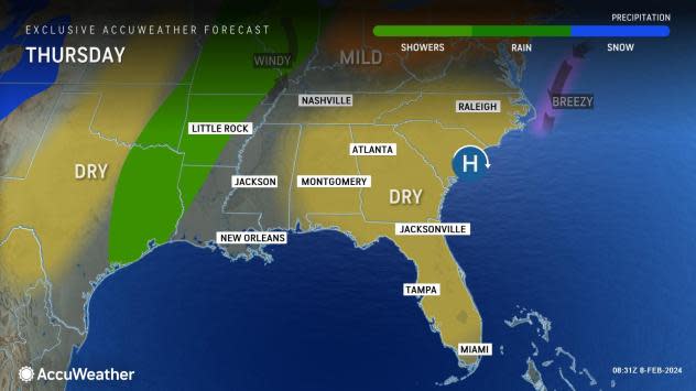
An area of high pressure will be anchored over the Southeast through at least Thursday, resulting in dry weather and clear, sunshine-filled skies this week. However, this high pressure area will begin to shift eastward off the coast by Friday.
 |
Residents along the Gulf coast and Southeast are encouraged to take advantage of the higher temperatures over the coming days. Locations like New Orleans and Mobile, Alabama, will experience highs in the 70s by the latter half of the week, roughly 5-10 degrees above typical early February temperatures. By early next week, high temperatures at both locations will drop back into the lower 60s F and closer to the historical average.
The first chance for light rain will arrive in areas of eastern Texas by Thursday as a cold front sways southward from the northern Plains. Showers can spread across the Mississippi Valley as the boundary slowly advances eastward Friday.
 |
Wind out of the Gulf of Mexico will help usher moisture into the Southern states. By Friday night into Saturday morning, this pattern will help to set the stage for a storm packed with rain and even a few thunderstorms to develop over the Southeast.
Southern cities such as Memphis, Tennessee, and Little Rock could collect between 0.10 and 0.20 of an inch of rain into Friday as the initial round of showers pushes through the region along the cold front. However, forecasters highlight that the rounds of rain and storms over the weekend could deliver impacts.
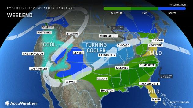
An additional round of rain is expected to advance northward from the Gulf Coast to the Carolinas over the weekend. This round will be followed up by another storm Sunday that will form along the Texas and Louisiana coast and bring repeated downpours to parts of the region through at least Tuesday.
 |
From Saturday to Tuesday, rainfall totals from eastern Texas to North Carolina will generally range from 1 to 3 inches, although experts say that locally higher amounts are possible where thunderstorms develop and rain persists day after day.
"While it is still early to rule out severe weather potential, the risk with this storm looks lower," explained AccuWeather Meteorologist Joseph Bauer.
Bauer added that there will be enough moisture to bring soaking rain and thunderstorms that could possibly lead to flash flooding concerns.
As the storm advances eastward and closer to the Southeast coast, winds will pick up across the region. By Sunday, gusts can reach speeds of 15-35 mph along the shorelines of the Carolinas, with higher gusts possible over the open ocean.
 |
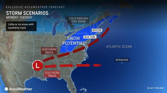
The storm could track one of two directions as factors come into play.
"Into early next week, this storm can either track off the Carolina coastline, spreading steady rain as it travels eastward, or it can take a more northeasterly path and encounter cold air pushing southward from Canada," explained AccuWeather Senior Meteorologist Tyler Roys.
If the storm travels far enough north, the mass of cold air shifting into the interior Northeast later this weekend will set the stage for snowfall potential. Residents from the mid-Atlantic states to New England should closely monitor this storm and its potential impacts.
Want next-level safety, ad-free? Unlock advanced, hyperlocal severe weather alerts when you subscribe to Premium+ on the AccuWeather app. AccuWeather Alerts™ are prompted by our expert meteorologists who monitor and analyze dangerous weather risks 24/7 to keep you and your family safer.
