
Severe storm risk surges across Alberta, Saskatchewan on Monday
3:23 P.M. MDT - Severe thunderstorms prompted a tornado warning in southern Alberta Monday afternoon. Environment and Climate Change Canada have since ended the warnings and replaced them with severe thunderstorm warnings.
EXPIRED TORNADO WARNINGS (ALBERTA):
Foothills Co. near Okotoks and De Winton
Foothills Co. near High River and Aldersyde
For more information on the threat for severe thunderstorms on the Prairies through the rest of the day on Monday, see the full forecast below.
The weekend brought a couple of days of active weather across parts of Alberta, with severe thunderstorms and a hail storm over Calgary, Alta. as the 2023 Calgary Stampede came to a close, much to the dismay of gardeners.
Unfortunately, as we head into the work week the severe storm risk will only build and become more widespread across the province, with the severe risk even extending into the western reaches of Saskatchewan.
The record-breaking heat dome that has settled over the western United States is creating what meteorologists are calling a "ring of fire" and driving thunderstorm development on the Prairies.

SEE ALSO: July's turbulent storm season keeping Calgary gardeners on guard
MONDAY
Areas: Central and southern Alberta; western Saskatchewan
Timing: Early afternoon to evening
Weather: After some active weather on Sunday, a low pressure system will develop by Monday afternoon across southern Alberta. Although this will help clear out the smoke, it’ll also increase the chances of severe thunderstorm activity across the province. The highest instability will build northeast of the surface low, while storms develop near the foothills around the noon hour.
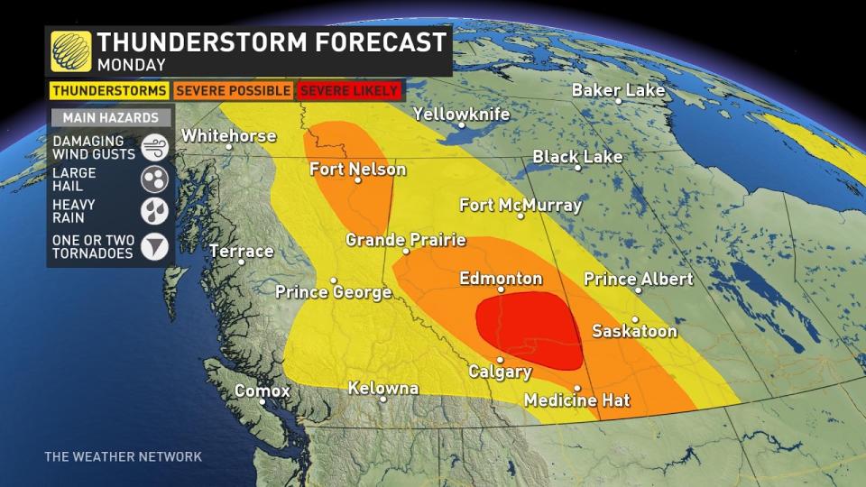
A chance of rotating supercells is possible across central Alberta near the Red Deer area, while clusters of linear thunderstorms also threaten western Saskatchewan into the early evening hours.
Large hail and damaging winds remain the primary threats, with the risk of a couple of tornadoes also possible along the warm front of the low-pressure system.
Confidence: Confidence is high that Alberta will have severe thunderstorm activity on Monday, but lower confidence on tornado potential with the storms. The main threats for this system will be damaging winds and the potential for large, golf ball-sized hail.

Thumbnail courtesy of Jill Traver, taken in Waskatenau, Alta.
Stay tuned to The Weather Network for more updates and information for your weather in Alberta and Saskatchewan.

