
Windy, winter weather makes a comeback in Sask. this weekend

Good Friday is a busy travel day — and it could be a challenging one for some Saskatchewan residents if the weather forecast is any indication.
Although we have seen beautiful spring weather in the past week, winter will make a comeback this weekend.
A strong storm system developed over the northern United States on Thursday. This system will push into Saskatchewan overnight into Friday.
Ahead of this system, strong winds have moved into Saskatchewan. Gusts could peak between 70 and 90 km/h Thursday evening in areas around Regina and Saskatoon.
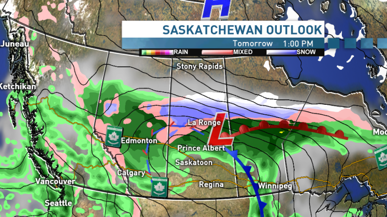
Rain has already moved into central Saskatchewan. By Friday, that will transition to snow, with the cooler air in behind the storm system. Heavy snow is expected in central Saskatchewan through the day on Friday.
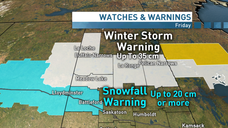
Most weather models are forecasting the bulk of the precipitation falling in a band between Meadow Lake and Cumberland House. Those areas could see anywhere from 25-35 cm of snow (or locally higher amounts) by the end of Friday.
Environment Canada has issued winter storm and snowfall warnings for north central Saskatchewan.
Forecasts at this point are pointing to heavy, wet snow piling up in Lloydminster late in the morning on Friday and into the afternoon. This will likely mean treacherous driving conditions on Highway 16 as that wet snow falls.
Exact accumulations will be hard to predict with this system because some precipitation will fall as rain and some will fall as snow. A small change in the storm's track could result in very different snowfall amounts for various regions.
Saskatoon's forecast
Saskatoon's forecast is a big question mark with this storm system.
Most weather models are keeping the system farther to the northwest. This would mean that Saskatoon would miss the snow wrapping behind the storm, and will see mostly rain.
If the storm system tracks farther southeast, there is the chance of Saskatoon seeing some snowfall through the day.
So, if you're planning your Good Friday in Saskatoon, it will likely be rainy, but the risk of a few flakes flying in the afternoon exists.
Regina's forecast
Regina looks to miss most of the precipitation with this storm system, but you could see showers in the Queen City through the day on Friday.
The wind has already started to affect Regina on Friday, ahead of this system. The wind should remain relatively strong, with gusts between 70 and 90 km/h over the next few days.
When will it let up?
Most of the snow and rain should ease up on Saturday as the storm system moves out of the region, but in its wake, cold northwesterly winds will remain. Gusts could near 70-80 km/h before they begin to weaken Saturday night.
Sunday will finally see the return of sun for central Saskatchewan, but cooler weather will remain for the end of the long weekend.
