
Heavy snow to blast Alberta while freezing air rests over the Prairies
A one-two punch of brutal winter weather is on tap for the Prairies in the coming days as a stark pattern reversal takes hold across the region.
Alberta will feel winter’s wrath first as several rounds of heavy snow traverse the southern foothills. Significant snowfall lasting into Tuesday will make travel nearly impossible across parts of the province. Some areas have the potential to see 30-40 cm of snow, locally up to 50 cm.
Behind the snow comes a blast of Arctic air, promising the region’s coldest temperatures since December. Wind chill values could dip into dangerous territory through the coming week.
MUST SEE: Wild ride to the winter finish line in Canada, find out your fate
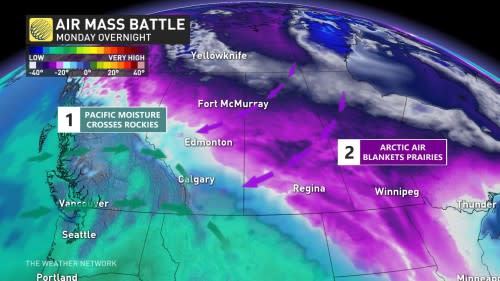
Winter returns with significant snow potential
A potent cold front aiming for eastern British Columbia and western Alberta will bring heavy snow to the regions beginning in earnest Monday and lasting into Tuesday.
The approaching low-pressure system will have plenty of cold air and Pacific moisture to work with, making it a formidable storm by the time it crests the Rockies to begin the week.
The first round of snow in Alberta arrives Sunday evening, with squalls impacting cities such as Hinton, Red Deer, Calgary and Medicine Hat.
Snow will then shift southwest on Monday, but the main event will push in towards the afternoon. Widespread snowfall will start to pick up towards the late evening into the overnight hours.
Heavier snowfall rates linger through Tuesday morning, becoming lighter in the afternoon and evening. The snow will be light and fluffy because of the Arctic air, so totals could be higher than expected.
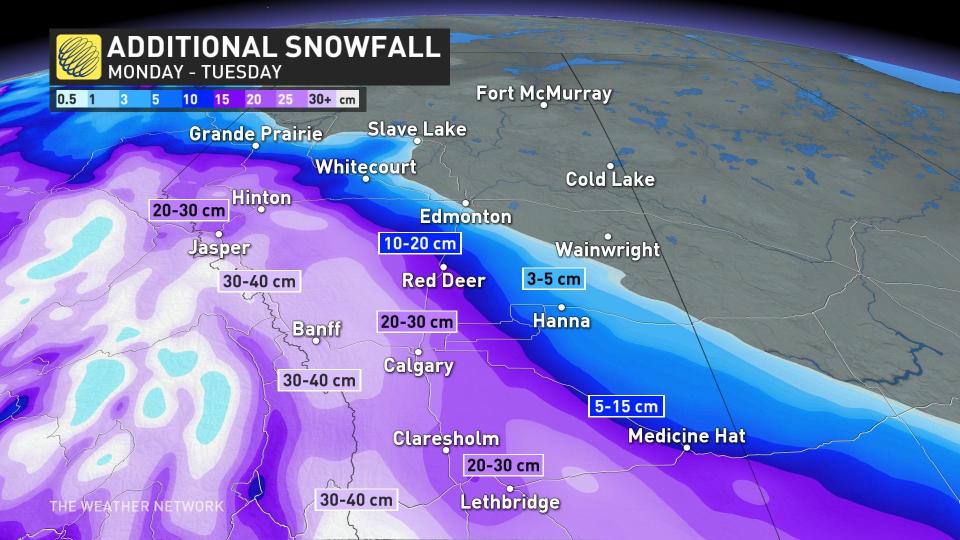
Snowfall totals will be significant across the western half of Alberta, stretching from just south of Grande Prairie to the southern border, and reaching as far east as Medicine Hat. Amounts in this swath will range from 10-40 cm, with most of it along the foothills where accumulations could reach as high as 50 cm locally.
Calgary, Alta., will be right in the middle, with projections of 15-30 cm for the major city.
As a result, travel will be greatly impacted throughout the southern portions of Alberta as this push of Arctic air forces its way into the region.
Arctic air to send temperatures diving, wind chills set to return
Across the Prairies as a whole, we’ve seen a series of unusually mild temperatures for more than a month now. This stretch of consistently above-seasonal conditions will come to an end in a hurry as this push of Arctic air crashes southward.
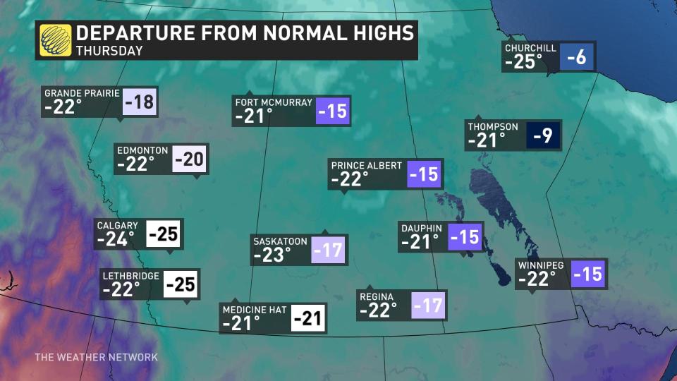
The coldest air associated with the trough will spill across the region on Tuesday and stick around for several days before letting up a bit.
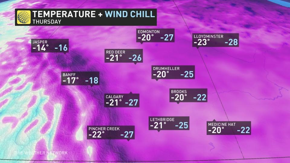
The deep chill pushing into Alberta will keep temperatures in Calgary and Edmonton firmly lodged in the minus double digits beginning Monday night and lasting through Saturday morning.
MUST WATCH: So your forecast calls for snow, but which type?
Regina and Saskatoon will see the coldest air arriving on Monday night and Tuesday. Each city will deal with several days of high temperatures in the -20s, with Saskatoon only predicted to hit -23°C on Wednesday.
Winnipeg will face Wednesday and Thursday with daytime highs only climbing to about -22°C, with overnight lows predicted to reach -27°C to -28°C multiple times through the week.
While these certainly aren’t the coldest temperatures we’ve seen, it’s going to feel especially raw given that it’s been so mild on the Prairies in 2023.
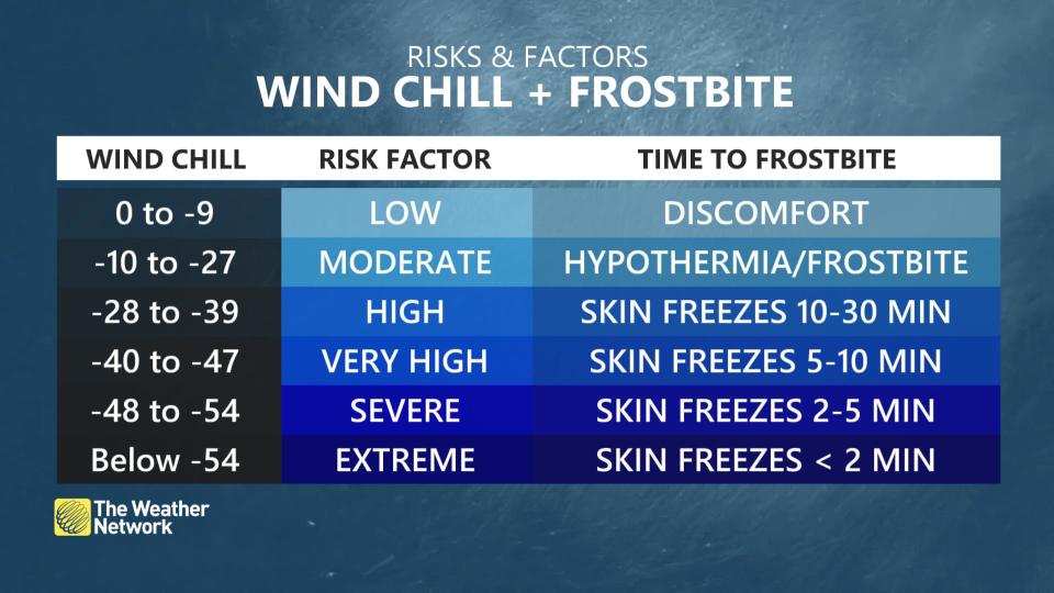
Winds certainly won’t help matters, either. Wind chill values will dip into the -30s and approach -40 for the duration of the coldest air next week, which will increase the risk for frostbite and hypothermia. Exposed skin can develop frostbite in as little as 10 minutes with wind chill values approaching -40.
This spell of cold air isn’t scurrying off anytime soon. Below-seasonal temperatures will stick around for much of the Prairies through the end of the month.
Stay with The Weather Network for the latest on conditions across the Prairies.

