
Winter-spring duel in Atlantic Canada to bring warmth, quick-freeze effects

With Ontario and Quebec experiencing a weather whiplash this week, from a spring fling to a winter rebound, one only has to look there to see what is coming to Atlantic Canada soon.
The East Coast will be propped up with spring-like temperatures, heavy rain and near-record warmth on Wednesday and Thursday, with daytime highs more typical of April than February. However, a strong cold front will race across the region soon after, sending temperatures diving in a hurry.
SEE ALSO: Rare winter hail pelts southern Ontario communities
As a result, there will be a risk for a flash freeze as heavy rain changes to snow due to a temperature drop of 10-25 degrees in a short amount of time. With potential for localized flooding, changing road conditions and slippery surfaces, expect treacherous travel during that time.
Strong winds are likely, too, with the cold front passage, with gusts of 60-100 km/h, depending on locale. Brace for some power outages, as well.
Wednesday and Thursday:
The Maritimes will be the first in the region to see impacts from the inbound system.

Rain will develop early in the morning and linger through the day. The heaviest time period will be during the evening and overnight.
As the day progresses and we hit the overnight period, wind gusts will intensify, reaching 60-90 km/h on Wednesday.

People will need to be cautious around waterways as a quick snowmelt from rising temperatures and rain could cause some rivers to overflow their banks.
By Thursday afternoon, rainfall will ease in the western Maritimes while beginning to fall in Newfoundland. It will be quick for the latter, as the rain will depart in the early overnight period.
Rainfall amounts will be heaviest in in southwestern areas of New Brunswick and Nova Scotia, with 60-100 mm possible for the former and 40-60 mm for the latter. Amounts of 20-40 mm are possible for eastern New Brunswick and southern Nova Scotia, with up to 50 mm for southwestern Newfoundland.
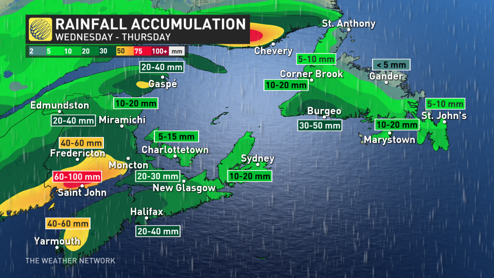
However, precipitation will be steady for the eastern Maritimes with some snow on the backside. Light rain is anticipated for southwestern Newfoundland, with northern and eastern regions seeing precipitation that is more scattered and lighter.
Wind gusts will be quite blustery, reaching 80-100 km/h for the southern Maritimes Thursday morning before easing into the afternoon. Make sure your devices will be charged as some power outages are expected due to the winds.

A strong cold front will then track across the region on Thursday, forcing temperatures to drop through the morning and afternoon for the Maritimes. Some areas of New Brunswick will dive down 20-25 degrees in six hours, while and around a 10-degree drop is expected in Nova Scotia and P.E.I.
Localized flooding will remain a concern for the Maritimes with snowmelt on Thursday. The good news is that the heavy rain is not associated with the greatest amount of snow on the ground.

Looking ahead, conditions will turn blustery and cold, with sea-effect snow, for Friday, but temperatures will rebound greatly on Saturday. Daytime high values will reach the double digits for much of the Maritimes.
Temperatures will be more typical of April, and even May, across the Maritimes through the middle of next week. Newfoundland will turn very mild for a few days next week. A couple of systems will bring primarily rain to the region mid- and late next week.
An active pattern is expected through mid-March, and it is possible that there will be more cold air available for messy systems during the second week of the month.
Stay tuned to The Weather Network for the latest forecast updates for Atlantic Canada.

