
Winter storm winds down in Newfoundland but more snow targets East Coast
Spring is here, but it doesn't mean the wintry weather is finished, especially on the East Coast.
Southern areas of Newfoundland, particularly areas along the coast, are on the receiving end of a potent winter storm, with some expected to see several hours of blizzard conditions before the storm moves out on Saturday afternoon.
DON'T MISS: Spring flooding in New Brunswick: Don't let your guard down
As of early Saturday morning, St. John's had already received nearly 20 cm of snow (18 cm east; 19 cm at airport), while 29 cm had been reported at Kilbride. Peak overnight wind gusts were excessive in some areas, with 132 km/h documented in Cape Pine, 124 km/h observed in Green Island and 92 km/h recorded in St. John's.
Winds resulted in blowing snow and reduced visibility.
Blustery southeast winds, with gusts of 70-90 km/h, will shift to the east-northeast during the day on Saturday.
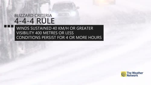
The blowing snow will subside over most areas Saturday morning as temperatures rise above zero, but winds will remain quite gusty.
RELATED: P.E.I. cleaning up spring snowfall, and could see more on weekend

“Consider postponing non-essential travel until conditions improve. If visibility is reduced while driving, turn on your lights and maintain a safe following distance,” ECCC advises in the winter storm warning issued for St. John’s and the surrounding area.
RELATED: Waiting for Sheila's Brush? Here's some of N.L.'s other weather lore
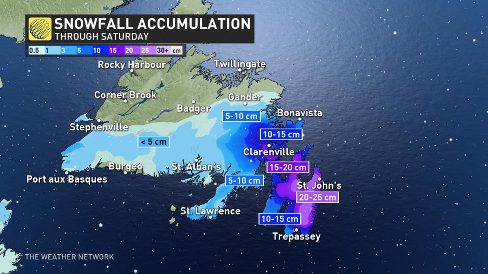
By the time conditions finally come to a calm Saturday evening, 20-30 cm of snow will have fallen over the Avalon, as well as 15-20 cm for Bonavista, Clarenville, and the Burin Peninsula.
More snow to conclude the weekend
This will not be the last storm that Atlantic Canada faces this weekend.
A weakening system tracking from the Great Lakes to central Quebec, and a developing low off the coast of England, will track into Nova Scotia and bring widespread snow to the Maritimes late Saturday night into Monday morning.
Snowfall totals are expected to be within the 5-15 cm range in most of Nova Scotia, with up to 20 cm for Cape Breton, and 15-20 cm for much of New Brunswick and 5-10 cm for P.E.I.

Thumbnail courtesy of JLaC/Twitter.
Keep checking back to The Weather Network for more forecast updates and information for Atlantic Canada.

