
Messy winter storm continues with more travel impacts for East Coast
A winter storm scraping along the East Coast will leave behind travel headaches for some and a mess to clean up for others.
The worst conditions will move into Newfoundland heading into Saturday, where a mix of snow and ice will continue as we start the weekend, making for dangerous travel across much of the island.
MUST SEE: Wild ride to the winter finish line in Canada, find out your fate
Folks across the Maritimes experienced the whole spectrum of wintry precipitation on Friday, with rain, freezing rain, ice pellets, and snow making a mess throughout the region.
Many communities lurched between two or more flavours of wintry weather as this dynamic storm pushed through.

The worst of it is over for the Maritimes, now, with some snow, ice pellets, and freezing rain on tap through the remainder of Friday evening. Conditions should improve as the storm pulls east through the overnight hours into early Saturday morning.
All eyes turn toward Newfoundland, and the Avalon Peninsula in particular, as this troublesome storm focuses its precipitation on the region.
The centre of the storm will track very close to the Avalon and Burin Peninsulas through midday Saturday, putting the region right on the knife’s edge between freezing rain, ice pellets, and plain old snow.
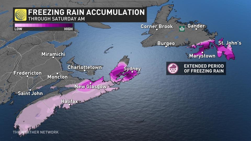
Parts of the Avalon and Burin are in for an extended period of freezing rain through Saturday morning.
“Surfaces such as highways, roads, walkways and parking lots may become icy and slippery,” Environment and Climate Change Canada (ECCC) said in its freezing rain warning for the region. “Be prepared to adjust your driving with changing road conditions.”

Precipitation on the two peninsulas may switch over to ice pellets Saturday morning as colder air pushes in behind the storm, likely ending as a period of snow as the system winds down into the afternoon hours.
Farther north, colder air locked in place will make this an all-snow event for the duration of the storm.

The greatest snowfall totals are expected on and around the Bonavista Peninsula, where we could see 20-30 cm of fresh snow on the ground by the end of the storm Saturday afternoon.
Temperatures will quickly rebound for much of the East Coast by Sunday and Monday, with milder conditions sticking around until a surge of Arctic air arrives by the end of the week.
Stay tuned to The Weather Network for the latest on conditions across Atlantic Canada.

