
Canada's first severe thunderstorm of the year was followed by snow
Saturday in Ontario was a prime example of what Mother Nature can deliver in a transitional season.
A strong Texas low moved across Lake Huron Saturday afternoon, while a trailing cold front swept across southern Ontario. The storm brought almost everything you can think of a spring storm: Snow, freezing rain, rain, intense, damaging wind gusts, and even a severe thunderstorm.
SEE ALSO: How vivid thundersnow stole the show in Toronto's big snowstorm
The result saw numerous trees and hydro poles toppled, large waves generated and power cut to thousands. Thousands are still in the dark, according to Hydro One, which has restored electricity to more than 48,000 customers so far.
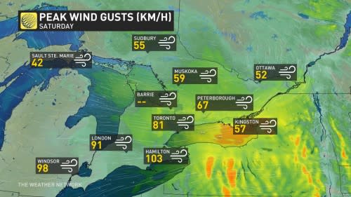
The winds were quite blustery in parts of southern Ontario, with 103 km/h gust recorded in Hamilton, 98 km/h documented in Windsor and 81 km/h observed in Toronto.
Just before 3:30 p.m. EDT on Saturday, Canada had its first severe thunderstorm warning issued by Environment and Climate Change Canada (ECCC).
The cell developed northeast of Lake St. Clair and then intensified, bringing with it wind gusts exceeding 90 km/h. The bulk of the cell passed northwest of London, Ont., impacting communities such as Strathroy-Caradoc and Lucan.
It's a reminder we're still in the early season of thunderstorm activity as it was snowing by 10 p.m. over the same region.
The thunderstorms were moving in excess of 80 km/h as the upper-level winds were racing, all associated with a powerful Texas low moving through the area.
Below is a selection of visuals from the storm currently circulating on social media.
ONStorm a little windy pic.twitter.com/85dD9f2nPp
frostedream on Twitter: "#ONStorm a little windy pic.twitter.com/85dD9f2nPp / Twitter" a little windy frostedream on Twitter: "#ONStorm a little windy pic.twitter.com/85dD9f2nPp / Twitter"
— frostedream (@Abinitio12) frostedream on Twitter: "#ONStorm a little windy pic.twitter.com/85dD9f2nPp / Twitter"
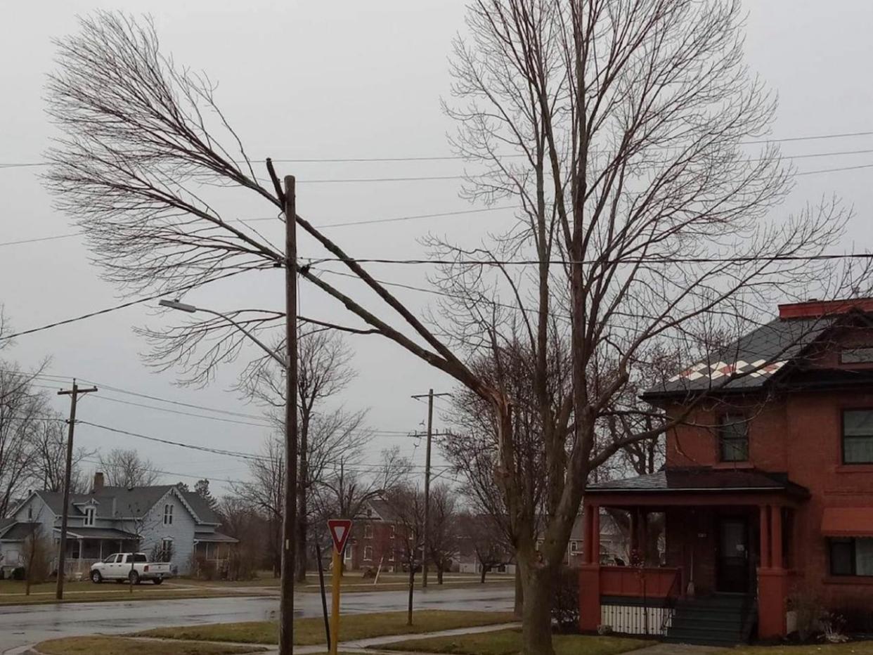
@WxOntario1 Goderich more pictures you can have I have took this morning the limb was just resting perfectly that it would not break anything power company was impressed with it too no wires where not harmed pic.twitter.com/sUIBTzTvt2
Aric Colborne Brindley one on Twitter: "@WxOntario1 Goderich more pictures you can have I have took this morning the limb was just resting perfectly that it would not break anything power company was impressed with it too no wires where not harmed pic.twitter.com/sUIBTzTvt2 / Twitter" Goderich more pictures you can have I have took this morning the limb was just resting perfectly that it would not break anything power company was impressed with it too no wires where not harmed Aric Colborne Brindley one on Twitter: "@WxOntario1 Goderich more pictures you can have I have took this morning the limb was just resting perfectly that it would not break anything power company was impressed with it too no wires where not harmed pic.twitter.com/sUIBTzTvt2 / Twitter"
— Aric Colborne Brindley one (@ARICBRINDLEY1) Aric Colborne Brindley one on Twitter: "@WxOntario1 Goderich more pictures you can have I have took this morning the limb was just resting perfectly that it would not break anything power company was impressed with it too no wires where not harmed pic.twitter.com/sUIBTzTvt2 / Twitter"
Strong winds this afternoon across Essex Cty, you may see situations like this one captured by a member of A platoon on Old Tecumseh Rd in the @TweetLakeshoreStay away from fallen power lines. Call 911 to report it. ^sd#EssexCtyOPP pic.twitter.com/Az5YqNVLdK
Strong winds this afternoon across Essex Cty, you may see situations like this one captured by a member of A platoon on Old Tecumseh Rd in the OPP West Region on Twitter: "Strong winds this afternoon across Essex Cty, you may see situations like this one captured by a member of A platoon on Old Tecumseh Rd in the @TweetLakeshoreStay away from fallen power lines. Call 911 to report it. ^sd#EssexCtyOPP pic.twitter.com/Az5YqNVLdK / Twitter"
Stay away from fallen power lines. Call 911 to report it. ^sdOPP West Region on Twitter: "Strong winds this afternoon across Essex Cty, you may see situations like this one captured by a member of A platoon on Old Tecumseh Rd in the @TweetLakeshoreStay away from fallen power lines. Call 911 to report it. ^sd#EssexCtyOPP pic.twitter.com/Az5YqNVLdK / Twitter" OPP West Region on Twitter: "Strong winds this afternoon across Essex Cty, you may see situations like this one captured by a member of A platoon on Old Tecumseh Rd in the @TweetLakeshoreStay away from fallen power lines. Call 911 to report it. ^sd#EssexCtyOPP pic.twitter.com/Az5YqNVLdK / Twitter"
So this happened while I was in town. The tree from our yard fell across the road! It's windy out there! Be safe! #ONStorm pic.twitter.com/XlTHoe143A
So this happened while I was in town. The tree from our yard fell across the road! It's windy out there! Be safe! Noobweps | Christina (🍕 Pizza Queen 🍕) on Twitter: "So this happened while I was in town. The tree from our yard fell across the road! It's windy out there! Be safe! #ONStorm pic.twitter.com/XlTHoe143A / Twitter" Noobweps | Christina (🍕 Pizza Queen 🍕) on Twitter: "So this happened while I was in town. The tree from our yard fell across the road! It's windy out there! Be safe! #ONStorm pic.twitter.com/XlTHoe143A / Twitter"
— Noobweps | Christina (🍕 Pizza Queen 🍕) (@noobweps) Noobweps | Christina (🍕 Pizza Queen 🍕) on Twitter: "So this happened while I was in town. The tree from our yard fell across the road! It's windy out there! Be safe! #ONStorm pic.twitter.com/XlTHoe143A / Twitter"
This just made an appearance. Interesting cell this is 🤔 Stayed that way for about 2 min. @GirlsWhoChase @LakeErieNorth @Onstormtracker @alluringstorms pic.twitter.com/9fZqrvT7aq
This just made an appearance. Interesting cell this is 🤔 Stayed that way for about 2 min. Tempest Hunter 🇺🇦☮ on Twitter: "This just made an appearance. Interesting cell this is 🤔 Stayed that way for about 2 min. @GirlsWhoChase @LakeErieNorth @Onstormtracker @alluringstorms pic.twitter.com/9fZqrvT7aq / Twitter" Tempest Hunter 🇺🇦☮ on Twitter: "This just made an appearance. Interesting cell this is 🤔 Stayed that way for about 2 min. @GirlsWhoChase @LakeErieNorth @Onstormtracker @alluringstorms pic.twitter.com/9fZqrvT7aq / Twitter" Tempest Hunter 🇺🇦☮ on Twitter: "This just made an appearance. Interesting cell this is 🤔 Stayed that way for about 2 min. @GirlsWhoChase @LakeErieNorth @Onstormtracker @alluringstorms pic.twitter.com/9fZqrvT7aq / Twitter" Tempest Hunter 🇺🇦☮ on Twitter: "This just made an appearance. Interesting cell this is 🤔 Stayed that way for about 2 min. @GirlsWhoChase @LakeErieNorth @Onstormtracker @alluringstorms pic.twitter.com/9fZqrvT7aq / Twitter" Tempest Hunter 🇺🇦☮ on Twitter: "This just made an appearance. Interesting cell this is 🤔 Stayed that way for about 2 min. @GirlsWhoChase @LakeErieNorth @Onstormtracker @alluringstorms pic.twitter.com/9fZqrvT7aq / Twitter"
— Tempest Hunter 🇺🇦☮ (@tempesthunterph) Tempest Hunter 🇺🇦☮ on Twitter: "This just made an appearance. Interesting cell this is 🤔 Stayed that way for about 2 min. @GirlsWhoChase @LakeErieNorth @Onstormtracker @alluringstorms pic.twitter.com/9fZqrvT7aq / Twitter"
Storms will be fighting the very cold waters of Erie as they make their way towards Niagara. In Crystal Beach now. @weathernetwork #ONStorm pic.twitter.com/2ieGbxuDRZ
Storms will be fighting the very cold waters of Erie as they make their way towards Niagara. In Crystal Beach now. Mark Robinson on Twitter: "Storms will be fighting the very cold waters of Erie as they make their way towards Niagara. In Crystal Beach now. @weathernetwork #ONStorm pic.twitter.com/2ieGbxuDRZ / Twitter" Mark Robinson on Twitter: "Storms will be fighting the very cold waters of Erie as they make their way towards Niagara. In Crystal Beach now. @weathernetwork #ONStorm pic.twitter.com/2ieGbxuDRZ / Twitter" Mark Robinson on Twitter: "Storms will be fighting the very cold waters of Erie as they make their way towards Niagara. In Crystal Beach now. @weathernetwork #ONStorm pic.twitter.com/2ieGbxuDRZ / Twitter"
— Mark Robinson (@StormhunterTWN) Mark Robinson on Twitter: "Storms will be fighting the very cold waters of Erie as they make their way towards Niagara. In Crystal Beach now. @weathernetwork #ONStorm pic.twitter.com/2ieGbxuDRZ / Twitter"
Getting intense at Long Point, gusts surpassing 70kmh #ONstorm pic.twitter.com/bM5UpT6K5H
Getting intense at Long Point, gusts surpassing 70kmh NZP Chasers on Twitter: "Getting intense at Long Point, gusts surpassing 70kmh #ONstorm pic.twitter.com/bM5UpT6K5H / Twitter" NZP Chasers on Twitter: "Getting intense at Long Point, gusts surpassing 70kmh #ONstorm pic.twitter.com/bM5UpT6K5H / Twitter"
— NZP Chasers (@NZPChasers) NZP Chasers on Twitter: "Getting intense at Long Point, gusts surpassing 70kmh #ONstorm pic.twitter.com/bM5UpT6K5H / Twitter"
Fierce waves coming over the break wall on Lake Erie at Crystal Beach. Home now and can hear it's getting worse. But, 5am comes early. #ONstorm #ShareYourWeather pic.twitter.com/ABIlg2cO3A
Fierce waves coming over the break wall on Lake Erie at Crystal Beach.
Home now and can hear it's getting worse.
But, 5am comes early. STORM WATCH- Lake Erie on Twitter: "Fierce waves coming over the break wall on Lake Erie at Crystal Beach. Home now and can hear it's getting worse. But, 5am comes early. #ONstorm #ShareYourWeather pic.twitter.com/ABIlg2cO3A / Twitter" STORM WATCH- Lake Erie on Twitter: "Fierce waves coming over the break wall on Lake Erie at Crystal Beach. Home now and can hear it's getting worse. But, 5am comes early. #ONstorm #ShareYourWeather pic.twitter.com/ABIlg2cO3A / Twitter" STORM WATCH- Lake Erie on Twitter: "Fierce waves coming over the break wall on Lake Erie at Crystal Beach. Home now and can hear it's getting worse. But, 5am comes early. #ONstorm #ShareYourWeather pic.twitter.com/ABIlg2cO3A / Twitter"— STORM WATCH- Lake Erie (@StormsOnErie) STORM WATCH- Lake Erie on Twitter: "Fierce waves coming over the break wall on Lake Erie at Crystal Beach. Home now and can hear it's getting worse. But, 5am comes early. #ONstorm #ShareYourWeather pic.twitter.com/ABIlg2cO3A / Twitter"
Possible small tornado touchdown just east of Lucan/west of #ldnont. Downed trees, strewn across road, power lines down. #onstorm pic.twitter.com/UBOaA4dEKq
Possible small tornado touchdown just east of Lucan/west of Hames on Twitter: "Possible small tornado touchdown just east of Lucan/west of #ldnont. Downed trees, strewn across road, power lines down. #onstorm pic.twitter.com/UBOaA4dEKq / Twitter". Downed trees, strewn across road, power lines down. Hames on Twitter: "Possible small tornado touchdown just east of Lucan/west of #ldnont. Downed trees, strewn across road, power lines down. #onstorm pic.twitter.com/UBOaA4dEKq / Twitter" Hames on Twitter: "Possible small tornado touchdown just east of Lucan/west of #ldnont. Downed trees, strewn across road, power lines down. #onstorm pic.twitter.com/UBOaA4dEKq / Twitter"
— Hames (@Real_Hames) Hames on Twitter: "Possible small tornado touchdown just east of Lucan/west of #ldnont. Downed trees, strewn across road, power lines down. #onstorm pic.twitter.com/UBOaA4dEKq / Twitter"
We got the very edge of it. West of #ldnont #ONStorm pic.twitter.com/PvPY8VlMVU
We got the very edge of it. West of Lisa on Twitter: "We got the very edge of it. West of #ldnont #ONStorm pic.twitter.com/PvPY8VlMVU / Twitter" Lisa on Twitter: "We got the very edge of it. West of #ldnont #ONStorm pic.twitter.com/PvPY8VlMVU / Twitter" Lisa on Twitter: "We got the very edge of it. West of #ldnont #ONStorm pic.twitter.com/PvPY8VlMVU / Twitter"
— Lisa (@BlueRaveFinn) Lisa on Twitter: "We got the very edge of it. West of #ldnont #ONStorm pic.twitter.com/PvPY8VlMVU / Twitter"
WATCH: Serious sparks fly as powerful winds rip across through southern Ontario
Thumbnail courtesy of Aric/Twitter/@ARICBRINDLEY1.

