
Category 3 Hurricane Lee forecast to begin northern turn in the middle of next week
Hurricane Lee dropped from its peak as a Category 5 storm on Friday to a Category 3 Saturday as it sucked in a little dry air and encountered some unfriendly conditions over the open waters of the west Atlantic.
But Lee remains a powerful hurricane as it treks west-northwest over the next few days on a path that keeps it clear of any inhabited land until at least next week, when its future grows a little more uncertain.
While the National Hurricane Center’s cone of uncertainty stretches out only over the next five days, where the storm appears to still be pointed toward the U.S. East Coast, long-range storm models continue to suggest Hurricane Lee will turn north in the middle of next week and avoid landfall anywhere in Florida.
The hurricane center is also tracking a second system, Tropical Storm Margot, which was about 970 miles west-northwest of the Cabo Verde Islands as of 11 a.m. Saturday. Margot was packing 45 mph winds.
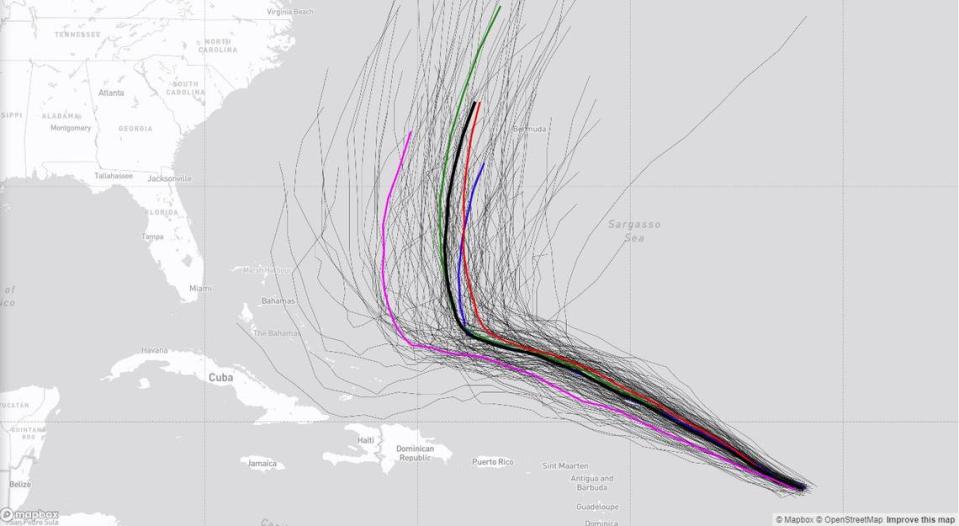
The two systems were lined up, almost like headlights on a car, on the hurricane center’s map of the tropics Saturday.
Tracking Hurricane Lee
The latest forecast takes Lee west-northwest over the weekend, where it could encounter some storm-disrupting wind shear and slow down a bit, before making the long-awaited turn north. The hurricane center expects Lee to slow its forward movement significantly later Saturday and Sunday with fluctuations in intensity. But Lee will remain a powerful hurricane into next week, the center said.
As of the 11 a.m. Saturday update, Lee was a Category 3 hurricane with 115 mph sustained winds about 350 miles east-northeast of the Northern Leeward Islands. It was headed west-northwest at 12 mph, and its hurricane-force winds extended up to 30 miles from the center and tropical storm-force winds extended 175 miles from the center.
Phil Ferro, chief meteorologist for WSVN Fox 7, said on Friday though the models have high confidence in Lee’s future turn, the atmosphere is “ever-changing” and everyone from Bermuda to the Northeast coast of the U.S. should keep an eye on the storm.
“What, if any, impacts it will bear next week on its path are still uncertain. While it remains very far away, keep checking in from time to time for updates,” he posted on X, the social media site formerly known as Twitter.
11AM AST Sep 9: @NOAA_HurrHunter & @53rdWRS find #Lee maintaining strength this morning. Hazardous beach conditions are expected around the western Atlantic through next week. Visit https://t.co/tW4KeGe9uJ for the latest information pic.twitter.com/xXiy8NY8Ux
— National Hurricane Center (@NHC_Atlantic) September 9, 2023
Rough surf ahead
If Hurricane Lee stays as far offshore as current forecast models suggest it will, Florida’s biggest impact from the storm could be rough waves and rip currents.
South Florida could see an increasing risk of dangerous marine, surf and beach conditions, including deadly rip currents, developing as early as Monday, according to Miami National Weather Service meteorologist Luke Culver. “Swells will gradually build through the week, potentially bringing a threat of beach erosion from rough and pounding surf across multiple high tide cycles late in the week.”
#HurricaneLee will produce some monster waves (50ft+ near the core). Swells start to arrive Tues-Wed along the SE Coast and work north. Surfers will prob love it, but careful folks. Big time rip current risk! New moon means slightly elevated tides/ coastal flooding/ erosion too. pic.twitter.com/NrPCOLsysT
— Jeff Berardelli (@WeatherProf) September 8, 2023
Models holding tight to a northern turn
“On the forecast track, Lee is expected to pass well to the north of the northern Leeward Islands, the Virgin Islands, and Puerto Rico into early next week,” hurricane specialist Lisa Bucci wrote in Saturday morning’s advisory.
By Friday afternoon, the hurricane center’s cone of uncertainty had begun to show a kink north, hinting toward the path that forecast models have been holding steady on for nearly a week — a northern turn away from the East Coast.
Nearly all global models have been suggesting a northern turn is imminent for the storm. But the models disagree on when, exactly, the behemoth storm could begin to twist north.
Most models suggest a turn in the middle of next week, while Hurricane Lee is still well north of even the northernmost Caribbean islands.
Tropical Storm Margot
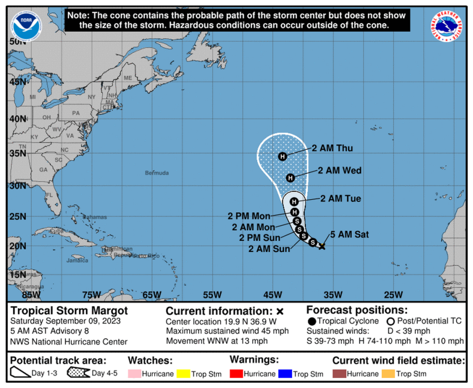
Tropical Storm Margot had strengthened over the open tropical eastern Atlantic Saturday morning, moving west-northwest at 12 mph.
Margot’s winds grew to near 45 mph with higher gusts early Saturday and held its intensity at 11 a.m. The storm is expected to strengthen gradually through early in the week and is forecast to become a hurricane Monday afternoon in the open waters and remain as such into Thursday.
A west-northwest to northwest motion is expected through early Sunday. A north-northwest to north motion is forecast to begin by late Sunday, hurricane specialist Larry Kelly wrote in Saturday morning’s report.
There are no hazards to land at this point. Tropical storm-force winds extend 45 miles from the center.
Tropical Storm #Margot Advisory 9: Margot Forecast to Become a Hurricane Next Week. https://t.co/tW4KeGe9uJ
— National Hurricane Center (@NHC_Atlantic) September 9, 2023

