
90-mph wind gust leaves Omaha airport again target of severe weather
OMAHA, Neb. – It's been a chaotic spring and summer at Omaha’s Eppley Airfield, and it has nothing to do with the busy travel season.
For the second time in two months, airport officials are assessing damage and juggling flights after severe weather swept through the airfield.
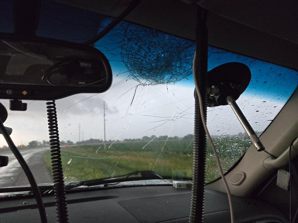
A line of severe thunderstorms moved over the sprawling facility Tuesday evening, pummeling the area with a half-hour of extreme wind gusts, including two separate gusts measured at 90 mph and another at 82 mph.
Officials shut down the airport for hours during and after the storm for damage assessment and debris removal. The airport reopened just after 1 a.m. CT, but airport officials warned of several flights that were canceled into Wednesday morning.
There were no reports of any injuries.
Nearly two months ago to the day, the airfield took a direct strike from an EF-2 tornado. While the passenger terminal was spared any damage, several general aviation buildings on the east side of the airport took a direct hit, officials said. The tornado's funnel was visible to airport weather observers for a full 35 minutes.
OMAHA AIRPORT TAKES SIGNIFICANT DAMAGE FROM EF-2 TORNADO
Damage in town in Tuesday’s storms wasn’t confined to the airport. There were a handful of storm reports issued by the National Weather Service describing trees and power lines down, with one home reporting shingles had been blown off.
At least 32,000 people lost power during the height of the storm, the NWS reported.
Several reports of large hail – some reaching 2-3 inches in diameter – impacted communities of eastern Nebraska and was large enough to damage windows.
FOX Weather Storm Tracker Brandon Copic was around Meadow Grove, Nebraska, when he was impacted by the giant ice.
And Hurricane Tracker Mark Sudduth was around Seneca, Nebraska, where he measured hail that was larger than golf balls.
Overall, there were over 150 reports of severe weather across the Midwest, including damaging winds, hail and tornadoes.
The Midwestern storms came on the heels of what was a stormy morning across Michigan and into Illinois and Indiana.
A line of severe thunderstorms rolled across parts of Lower Michigan early Tuesday morning. Wind gusts to 71 mph were reported in Muskegon as the storms blew through just after 6 a.m. ET. In the wake of the powerful storms, more than 170,000 people were without power in the state, according to PowerOutage.us.
Muskegon County Emergency Services reported that first responders were busy responding to calls regarding multiple car accidents, fallen trees, downed power lines and impassable roads.
County officials activated their emergency operations center after northern areas of the county suffered damage.
Later Tuesday morning, the same line of storms also prompted a ground stop at both Chicago O'Hare and Midway airports as thunderstorms rolled over the airports with gusts to 43 mph, leading to numerous flight delays.
Original article source: 90-mph wind gust leaves Omaha airport again target of severe weather

