
The Columbus Riverwalk is flooding more. How often is the city’s icon underwater?
The Columbus stretch of the Chattahoochee River rises and falls like vital signs on a heart monitor throughout the year. Shallow summer lows reveal caramel-brown boulders while winter and spring high depths cover entire trees and create whitewater that makes the river roar.
The volume and height of the water have fluctuated since record-keeping began in the Columbus area in 1929, according to data from the U.S. Geological Survey archives and current monitors at the 14th Street bridge.
But significant high water events of at least 25 feet in the Chattahoochee have happened more in the last 10 years than in the previous 30, when the Columbus Riverwalk was constructed. It’s also taking longer for water levels to fall, causing the river to become more like a temporary lake and drowning the Columbus Riverwalk for days.
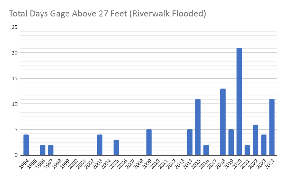
From 1993 to 2024, there were 100 days in which the riverwalk was underwater from 42 flood events. Seventy-five of those days were from 2014 to 2024, explained Senior Service Hydrologist, Laura Belanger at the NWS.
There are a lot of factors that are creating this increase in flood frequency and duration, Belanger said.
“It’s hard to draw one specific conclusion but there are things we know for sure and that is, in theory, it’s going to get worse from climate change,” she said.
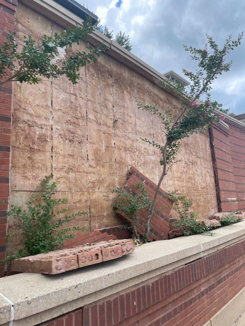
When the 31-year-old riverwalk is underwater from flooding, the consequences are much more significant than recreational access.
Arguably, the largest economic driver in Uptown Columbus comes from the river, which draws in millions of tourists who use the river to white water raft and kayak every year. On any given day an angler will have their fishing pole hanging on the rails of the riverwalk. In 2023, Muscogee County had 13,631 fishing licenses, according to the Georgia Department of Natural Resources.
Flood events damage the riverwalk itself, and those incidents add more bacteria to the river from sewage inundation, and parts of the sewage system back up throughout Columbus.
The maze of combined sewer overflow pipes snake below the riverwalk and throughout the city. The system was built to handle a certain amount of water before the rainwater and sewer overflow during high rain events. At 25 feet in crest height, the river begins approaching the riverwalk in Columbus, at 27 feet it begins to flood.
These are the signs that the river is flooding more often and for a longer duration:
Since 1993, there have been 42 flood events (where the river level rose above 25 feet).
More than half, 25, happened in the last 10 years.
16 of the 25 in the last 10 years have been above 27, considered a “minor flooding” stage.
The 16 events in the last decade lasted on average 4.7 days. Between 1993 and 2014, they lasted only 3.25 days.
What interests Belanger is that “the duration of the events is increasing,” she said in an email.
Gabriel Perez, a hydrologist who studies the effects of extreme floods, called the last 10 years of high crest events, “striking.”
“It is the city icon,” Billy Turner, former president of Columbus Water Works and project leader for the Riverwalk path construction in the early 1990s, said when describing the riverwalk.
“[The riverwalk] was designed to be flooded,” Turner told the Ledger-Enquirer. “We expected it to be flooded on average about twice per year. It was designed around rain events to provide for the treatment capacity in the system.”
So why is the expected average of two days up to four and a half days in the last decade?
The why is complicated
The Chattahoochee River basin has 4,630 square miles of drainage area. Its sheer size complicates this question.
“One of the most difficult things to answer is whether rainfall can equate to streamflow…especially because the Chattahoochee is such a long and big basin,” Perez said.
Four main elements are all happening in tandem to cause flooding events, according to several hydrologists interviewed by the Ledger-Enquirer:
Heavy and extreme rainfall locally in Columbus (more frequently induced by human-caused climate change).
Rain events above the North Highlands Dam (including events in Atlanta) and Georgia Power’s decision to release outflow.
West Point Lake Dam outfall fluctuations, determined by NWS and the Army Corps of Engineers.
Drought in the region–soil moisture conditions around the basin that either leave the ground ripe for water sequestration or over-saturation
Locally, rainfall has increased in the last 10 years, according to the rain gauge at the Columbus Airport.
Since 2009 there have been more heavy rain events in Columbus above 2.5 inches, with nine events above 4 inches, compared to only four events from 1990 to 2008, recorded at the Columbus Airport rain gauge.
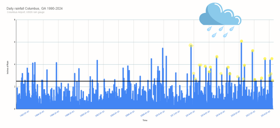
“There is a clear trend of increased precipitation in the region,” Perez said.
Because Columbus is at the bottom of the massive basin, all rain events between North Highlands Dam and Atlanta need to be considered.
Next, and perhaps most significantly, is the West Point Lake Dam’s outflow that dictates what will come down the river to Columbus. It was built for flood control purposes.
These streamflows are in cubic feet per second, and this is different from flooding or crest events. This is the amount that is being discharged and the volume, which is partially a result of the West Point Lake dam outflow.
“Prior to the construction of West Point dam in 1971, the river got up into the street, all the way up to Broadway,” Turner said.
When a rain event happens in Atlanta, the Army Corp of Engineers, NWS and other entities coordinate to ensure West Point Lake can handle the incoming inundation from Atlanta, which means more water comes to Columbus.
“West Point ACOE tries to get rid of water a little bit at a time and uses our forecasts to do that,” said Todd Hamill, hydrologist at the NWS.
The Columbus stretch of the Chattahoochee after 1975 created an entirely different river reality in Columbus.
Then, there’s drought. The last several years have not had as much drought, according to Hamill.
“There was a significant drought in the early 2000s. But in the last 10 years we haven’t had much drought,” Hamill said.
El Nino years tend to be wetter, which is an added consideration, he added.
“If the basin system is dry, the watershed has more capacity to absorb the water that is coming from precipitation and that will add into stream flow or peak flow magnitude in the system,” Perez said. “The soil conditions will depend on the land use from urban areas.”
To understand a single flood event, hydrologists would have to consider all of these factors, making a single attribution nearly impossible.
But these three points scientists know for certain:.
It is raining more in the Southeast
Columbus floods linger longer
There is more water vapor on a warming planet.
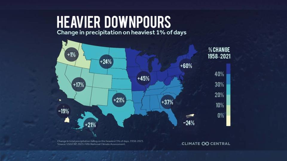
Scientists know that more moisture in warmer air increases the chances that rain falls in heavier downpours.
The Intergovernmental Panel on Climate Change (IPCC) used 33 models to determine the precipitation patterns. Perez showed the Ledger-Enquirer the new ‘pinpoint’ feature where you can now go to exact coordinates.
On a 1.5 degree C warmer planet Columbus will see more rain during rain events by 10%. So if it is 2 inches today that may look like 2.2 inches in years to come.
The ripple effects – what can the system handle?
The $100 million dollar riverwalk project included two combined sewer treatment facilities (one near the Civil War Naval Museum and Second Avenue and 19th Street).
“The large pipes that extend under the riverwalk were designed to eliminate combined sewer overflow problems,” Turner said.
When the area gets more than 0.63 inches of rain per hour, the stormwater flows into the sanitary sewer system and the combined flows overwhelm the wastewater treatment plants.
“When the system can no longer manage the amount of combined flows, a mix of minimally treated wastewater and stormwater is discharged into the Chattahoochee River (primarily through pipes that release underwater and out of sight),” Ashley Desensi, technical program manager for the Chattahoochee River Keepers, said in an email. “There is a high likelihood that the water contains high levels of bacteria.”
Vic Burchfield, the VP of Columbus Water Works who works to maintain the water and sanitary sewer system said the sewer line is designed to only collect so much sewage.
“It’s designed for dry conditions,” he said.
The sanitary sewer system is designed to handle 0.23 inches of rain per hour, according to Burchfield. Sanitary system overflows can happen when discharge from commercial and residential customers drain combined with high flooding, and the manholes get covered in water or water pours off them.
The city will put up barricades before an event after they are notified by the NWS.
“The clean up process can not begin until the water has receded and it can persist for months after a significant event,” Public Works Director Drale Short said.
The Columbus Emergency Management Department told the Ledger-Enquirer they work closely with the NWS, Georgia Power, and the city during high rain events.
“We discourage people from fishing, kayaking, boating when the river is in flood stage because we want them to be safe,” Chance Corbett, EMS director said.
“Occasionally we have a kayaker who gets in the water, but most people understand they should stay away,” Fire Department Chief Rick Shores said. “Drowning happens on really hot days when people want to get in.”

