
Despite rain, drought lingers in the Triangle, across NC. How much more do we need?
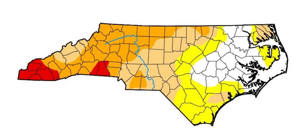
The majority of North Carolina is still experiencing drought conditions despite weekend rains, the U.S. Drought Monitor reported Thursday.
Last weekend’s rain was enough to lift some areas in the southwestern corner of the state out of extreme drought, but only to severe drought status.
Much of the state west of Greensboro remains in severe drought, per Thursday’s update. In the Triangle, Durham and Orange counties remain in moderate drought while Wake County is abnormally dry.
The dry conditions cap a dry climatological fall, which ended Thursday, Corey Davis, North Carolina’s assistant state climatologist, told The News & Observer.
“The event last week was a good start, and we generally saw an inch to an inch and a half statewide, but some of those western areas didn’t see quite as much so the benefits were fairly limited,” Davis wrote in an email. “Ultimately, it will take more events like that one this winter to keep chipping away at those deficits and recharge the soils, streams and lakes that have dried out so much this fall.”
Between Sept. 1 and Oct. 30, Raleigh saw 9.13 inches of rain, 2.71 inches below normal. Charlotte’s 4.35 inches of rain this fall were less than half its 10.18-inch normal, and Franklin’s 3.24 inches of rain were about a fourth of its 12.41-inch normal.
“Those deficits give a feel for the different ‘flavors’ of drought across the state at the moment, and also a decent idea for how much rain it will take to get out of drought, on top of our normal precipitation,” Davis wrote.
Raleigh averages about four inches of rain in December, Phil Badgett, a meteorologist at the National Weather Service’s Raleigh office, told The N&O. But, Badgett said, the area actually needs additional rain to emerge from drought status.
“It’s going to take quite a bit of rain,” Badgett said, noting that Raleigh saw about 20% of its typical October and November precipitation this year.
Those deficits have resulted in conservation measures for some water utilities in North Carolina. The City of Durham, for example, has been asking its customers to reduce their water use by 10% to 20% since mid-September as water levels in Lake Michie and Little River Reservoir have stayed well below full.
Officials have maintained that El Niño weather conditions will likely result in a wet winter, but the impacts aren’t expected to become visible until early 2024.
A rainstorm that brought about 1.4 inches of rain to the Triangle last week may have been the start of that pattern, Badgett said. Over the next couple of weeks, rainfall is expected to return to levels that are either normal or just below it.
“We should start getting system after system. We’ll start nickel-and-diming it and it just kind of takes a while to kind of knock it back,” Badgett said, referring to the drought.
The southwestern North Carolina mountains, where drought is still the heaviest, also tend to see heavier rains during El Niño winters, Badgett said. The weather pattern can also result in winter storms in the area, if a storm coming out of the south meets a polar jetstream coming from the north.
“It should be a pretty interesting winter, to say the least,” Badgett said.
This story was produced with financial support from the Hartfield Foundation and 1Earth Fund, in partnership with Journalism Funding Partners, as part of an independent journalism fellowship program. The N&O maintains full editorial control of the work.

