
High tide, flooding forecast for southwest B.C.
Rainfall warnings and flood watches remain in effect for southwest B.C. as two successive storms are forecast to bring 60 to 120 mm of rain by late Tuesday night, according to Environment Canada.
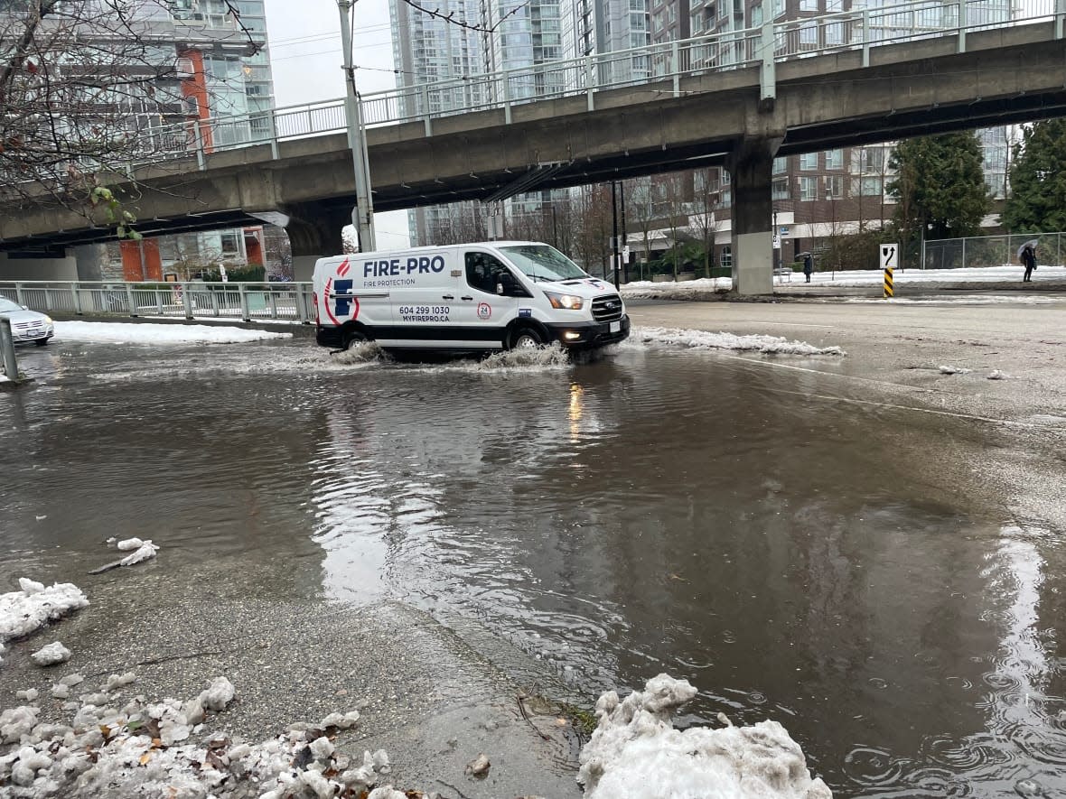
Coastal flooding near the Strait of Georgia is expected around the high tide on Tuesday morning, the agency said. And Vancouver is bracing for an elevated risk of flooding due to a storm surge with high winds and a high tide, which is seen reaching a record around 9 a.m. PT, the city said in an information bulletin.
Meanwhile, the provincial River Forecast Centre says flood watches remain for Howe Sound, North Shore Mountains, Central, West, and South Vancouver Island and the Lower Mainland including Sumas River. About 25 to 100 mm of rain has fallen in the area since Sunday.
Another storm is expected to move across the region Monday night and Tuesday, bringing moderate to heavy rainfall and snowmelt, the centre said.
In the centre's three-tiered warning system, a flood watch means river levels are rising and flooding might occur. It is followed by a high stream-flow advisory, the lowest of the three levels issued by the River Forecast Centre, that indicates minor flooding in low-lying areas is possible.
High stream-flow advisories are in place for North Vancouver Island and the South Coast, including the Sunshine Coast and surrounding tributaries, after up to 145 millimetres of rain and 20 millimetres of snowmelt was observed in the region Sunday.
Meanwhile, a potential storm surge and king tides — extremely high tides that happen about twice a year when the sun and moon's gravitational forces reinforce each other — along the Strait of Georgia and B.C.'s southeast coastal regions have prompted a warning to be on alert for flooding and damage to coastal infrastructures.
Environment Canada has forecast king tides along the coast of B.C. will reach their highest levels Tuesday morning. The River Forecast Centre has also warned of flooding in Courtenay River, Englishman River, Cowichan River as well as other river outlets, particularly along the east side of Vancouver Island at approximately 9:00 a.m. PT.
The City of Vancouver said there could be flooding in areas such as the Fraser River, English Bay, False Creek and Burrard Inlet. Low-lying areas, including Southlands, Fraser River floodplain and Locarno/Spanish Banks may also flood.
The Stanley Park seawall will be closed Tuesday from the Lions Gate Bridge to English Bay and in front of Kits Pool as a precaution, the city said.
About 2,400 households on Vancouver Island and nearly 300 in the Lower Mainland and Sunshine Coast remained powerless on Monday, as of 4:45 p.m. PT. Poor weather conditions and access challenges have caused delays in making repairs in some areas, BC Hydro said.
After hundreds of flight cancellations in the past week, the Vancouver Airport Authority reported about 97 per cent of originally scheduled flights at YVR were operating as of Monday at 11:46 a.m. PT.
Highway closures due to poor road conditions
Drivers are urged to avoid unnecessary travel. Snow and freezing rain, which could lead to avalanches, is forecast in the Southern Interior until Tuesday, according a weather statement from the province. And most of the Central Interior can also expect freezing rain Monday, according to Environment Canada.
Freezing rain — when low surface temperatures cause rain to reach freezing temperatures near the ground — remains a threat for the South Coast. And that can lead to icy and slippery roads and hazardous driving conditions.
Travel advisories remain in place for many provincial highways, urging motorists to only make essential trips.
Multiple highways were closed due to high avalanche risk and severe icing conditions. The highways affected are:
Trans-Canada Highway between Golden, B.C., to Revelstoke and Hope, B.C., to Boston Bar.
Highway 3 at Kootenay Passs, for a stretch of 18 kilometres.
Highway 31 at Lardeau on the north end of Kooteney Lake.
Highway 23 between Revelstoke and Mica Dam, for a stretch of 143 kilometres.
A passenger bus crash on Highway 97C, or the Okanagan Connector, on Saturday night led to four deaths and dozens of injuries, forcing the closure of the highway until Sunday morning.
Police said the investigation into the rollover is ongoing, but it's believed extremely icy local road conditions were a factor.
Dave Duncan, general manager with the Yellowhead Road and Bridge (Nicola), in the Merritt area, said the roads where the "terrible tragedy" took place were icy with a mix of snow and slush.
Saturday "was a particularly challenging day. There were travel advisories in effect put out there by the province for most corridors for the day," he said.
Duncan said there were 14 plow trucks for road safety work, of which four were dedicated especially for the Okanagan Connector.
He advised motorists to pay attention to travel advisories in place and check DriveBC before making any plans.
"Winter conditions and winter routes can change so quickly and conditions can be so variable … folks really should heed it and not travel unless they absolutely have to on the highway corridors."

