
Florida rainstorm to target New England by this weekend
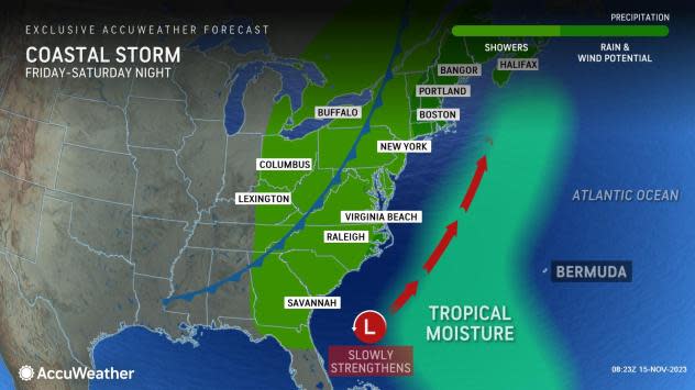


The same storm responsible for torrential downpours and flash flooding in South Florida will swing northward along the East Coast and eye the mid-Atlantic before bringing drenching rain and gusty winds to New England Saturday, AccuWeather meteorologists say.
The storm brought over a foot of rain to parts of southeastern Florida into Thursday before setting its sights farther north in the United States late this week.
"As the storm gains latitude, it will gain some strength as well," AccuWeather Storm Warning Meteorologist Joseph Bauer said.
 |
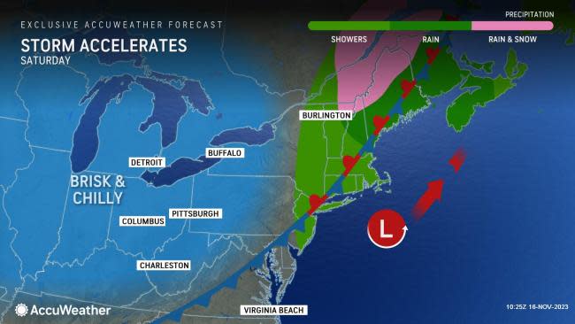
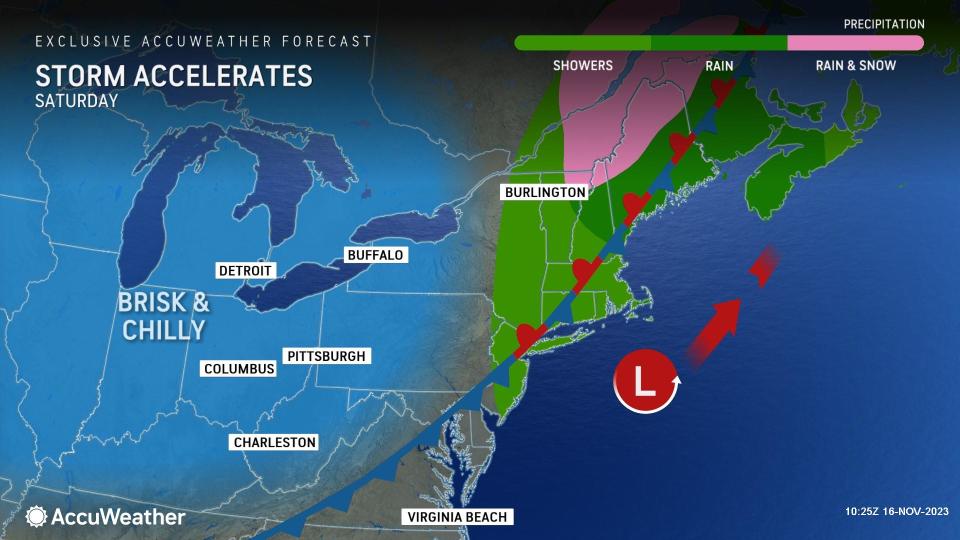
"This storm is likely to track just far enough to the east to avoid bringing much rain to the mid-Atlantic region from Friday to Saturday," Bauer added. Latest data suggest the bulk of the storm will also swing to the east of western and central New England as well.
AccuWeather meteorologists also do not expect the storm to evolve into a blockbuster in the Northeast but rather a more typical rainstorm that causes disruptions to outdoor activities and leads to travel delays associated with wet and windy conditions in Cape Cod, Massachusetts, which has weathered many potent nor'easters over the years.
 |
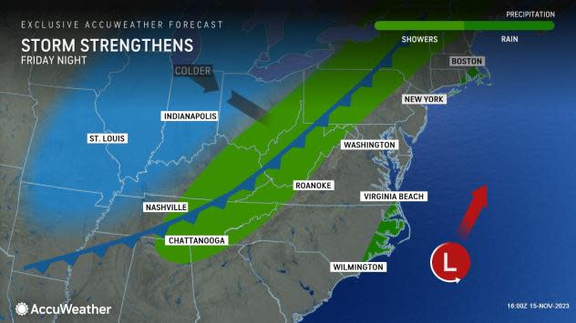
Early this week, forecasters were analyzing how quickly the storm might merge with an approaching cold front, noting that a quick merge could lead to a powerful nor'easter and spread heavy rain and high winds over New England and much of the mid-Atlantic. Instead, it appears the storm and front will come together for a potent system over Atlantic Canada this weekend.
"Because of the track of the storm being a bit weaker and farther to the east, and that moisture along the approaching cold front may get wrung out over the Appalachians little, and in some cases no, rain may fall from the entire event from Friday to this weekend in parts of the mid-Atlantic," AccuWeather Senior Meteorologist Dave Dombek said.
 |
New York City is among other metro areas along Interstate 95 in the mid-Atlantic, where little rain is likely to fall. A couple of showers are in the offing around the metro area from Friday night to Saturday morning.
Meanwhile, the Boston area will be on the edge of the Atlantic storm's rain and wind zone on Saturday, which will be the worst of the two weekend days. Some minor incidents of coastal flooding are possible. Atlantic Ocean water will be pushed toward the shoreline of eastern Massachusetts by north winds.
Just enough cold air may sneak into the storm at the last minute over northern New York state and northwestern New England to allow rain to end as a period of snow Saturday.
 |
Brisk and chilly conditions will sweep across the Northeast after the storm spanning Saturday night and Sunday. The change in air will replace temperatures from 10-20 degrees Fahrenheit above the historical average on Thursday and Friday with temperatures of 5-10 degrees below the historical average later this weekend.
On Sunday, temperatures may fail to reach the freezing mark in northern Maine and may be no better than the mid-50s around the Chesapeake Bay.
A trailing disturbance in the chilly air may help set off spotty snow showers from southern Ontario to upstate New York, northeastern Ohio and northwestern Pennsylvania on Sunday.
Monday will bring dry conditions across the Northeast, but the push of chilly air will help pave the way for a new storm that will ramp up over the South Central states.
 |
That storm will likely grab some moisture from the Gulf of Mexico and produce a zone of rain and thunderstorms over the lower part of the Mississippi Valley, which will then spread into the Ohio Valley and central and southern Appalachians Tuesday morning.
The contrast of cool air in the Northeast and warm air in the South should boost the intensity of the rain so that some areas may receive a thorough soaking.
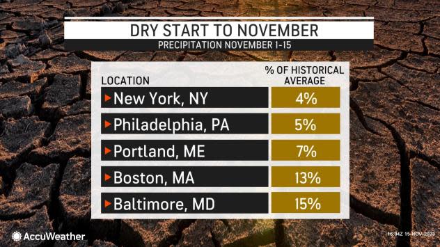
The first half of November has been very dry in much of the region. Many locations have received less than one-quarter of their average rain for the first two weeks of the month. In New York City, there has been less than 0.10 of an inch of rain so far this month, compared to a historical average of 1.62 inches.
 |
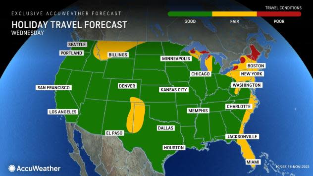
While the rain is needed, it will come at a potentially disruptive time. The rain will expand eastward on two of the biggest travel days of the year: the Tuesday and Wednesday before Thanksgiving. More than 55 million people are projected to travel by road, sky or rail during the days surrounding Thanksgiving, according to the American Automobile Association (AAA).
The rain will expand to the mid-Atlantic and New England regions during Tuesday afternoon and night. Since the storm is likely to keep moving along, some improvement is possible during Wednesday afternoon and night, but the rain and associated poor visibility earlier on may have ripple effects on later flights at a number of the airports.
As colder air pours in behind the storm next week, places closer to Lake Erie and Lake Ontario may have to contend with lake-effect snow on Wednesday, which could be heavy enough to bring wintry travel and reduce visibility at times.
 |
Conditions look to be mainly dry in the Northeast on Thanksgiving Day.
Want next-level safety, ad-free? Unlock advanced, hyperlocal severe weather alerts when you subscribe to Premium+ on the AccuWeather app. AccuWeather Alerts™ are prompted by our expert meteorologists who monitor and analyze dangerous weather risks 24/7 to keep you and your family safer.
