
Saturday to be another peak day during dangerous central US severe weather outbreak
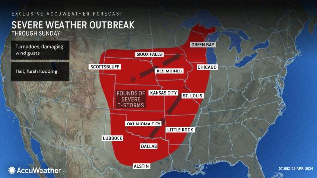

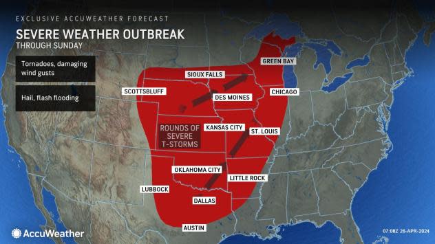


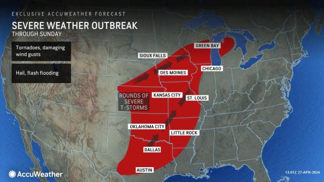

A multiple-day severe weather outbreak packing powerful wind gusts, tornadoes, large hail and flash flooding will pose a significant risk to lives and property in the middle of the United States into Sunday, AccuWeather meteorologists continue to warn.
The threat of severe weather returning to a portion of Tornado Alley that makes up much of the Great Plains after a lull over the past few years was brought to attention by AccuWeather's long-range team months ago during the spring outlook. Over the past week, this concern has been reiterated on the company's media platforms, network and app.
 |
The likelihood of violent storms capable of causing injury and property damage will extend into the nighttime hours each night through the weekend, adding to the danger. Some areas will be at risk for severe weather for two or three days in a row.
Two storm systems will cause the majority of the trouble over the Central states, AccuWeather Chief On-Air Meteorologist Bernie Rayno said.
The first storm brought dozens of reported tornadoes to the area from eastern Nebraska into southern Iowa, a number of which were confirmed through pictures or video posted on social media.
"The second storm will swing out from the southern Plains to the Midwest this weekend," Rayno explained.
 |
In addition to the threats to lives and personal property, power outages will occur and could be lengthy in some areas, depending on the scope of damage to infrastructure.
Following locally heavy and gusty thunderstorms, some packing hail from parts of Nebraska to portions of Kansas, Missouri and Iowa into Thursday afternoon, the first eruption of intense thunderstorms began late Thursday over far western Kansas. Several of the strongest storms produced large hail.
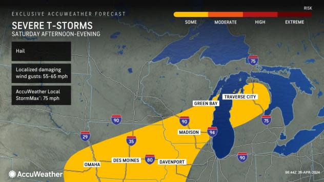
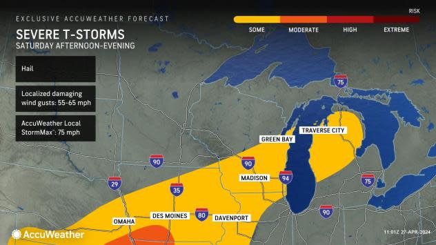
The last gasp of severe weather with this first storm will pivot into Ontario, Canada, on Saturday with locally severe storms capable of producing damaging wind gusts, hail and brief flooding downpours from Iowa to southern Wisconsin and the northern parts of Lower Michigan and Illinois.
 |
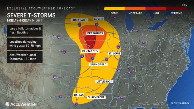
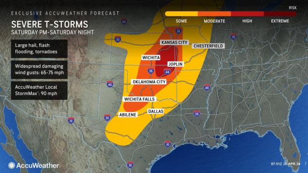
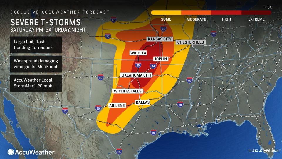
However, energy from the second storm system will come into play over the southern and central Plains on Saturday. Along with that will come the likelihood of storms with large hail, damaging wind gusts, tornadoes and flash flooding from north-central Texas to northern and western Missouri and southeastern Nebraska.
"The most intense storms and correspondingly a high risk of severe weather with storms capable of producing strong tornadoes and intense wind gusts from Saturday afternoon to Saturday evening will extend from northeastern Oklahoma to southeastern Kansas and southwestern Missouri," Walker warned.
 |
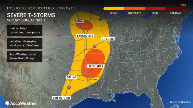
Later on Saturday night, in much of the severe weather zone over the central and southern Plains, Walker added that the risk would mainly be for strong wind gusts and flash flooding.
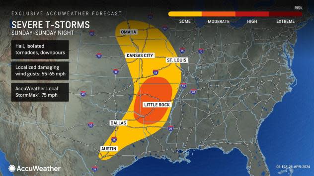
By Sunday, the potential for locally severe thunderstorms will extend from eastern Nebraska and western Iowa southward to central Texas. Sunday's main threats will be briefly damaging wind gusts, hail and flash flooding. However, a few tornadoes along the zone cannot be ruled out. The most likely area for tornadoes would be in Arkansas.
 |
While the greatest risk for tornadoes will run through Saturday evening, any severe thunderstorm can produce a brief tornado through Sunday evening.
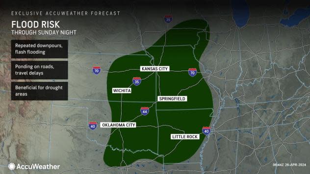
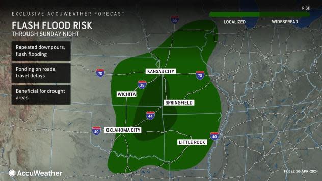
Along with the risk of violent thunderstorms and highly localized flash flooding in the coming days, torrential rain will likely trigger flash flooding on a more regional basis.
That zone extends from southern Arkansas, northward to southeastern Iowa, as far to the west as central Kansas and Oklahoma, and as far to the east as parts of Illinois. The Ozark Mountains, where many people may be camping near small streams or secondary roads prone to high water, are in the middle of the flash flood threat zone.
 |
Some locations within the outlined flood risk area may receive 4-6 inches of rain. Much of that rain could fall within a few hours.
Beyond Sunday, the main outbreak of severe weather will have ended. But there can be two pockets of heavy to locally severe storms in parts of the Midwest and Northeast, as well as the lower Mississippi Valley to Texas. The area of heavy rain and flash flooding may also settle slowly farther to the south over the Central states.
Want next-level safety, ad-free? Unlock advanced, hyperlocal severe weather alerts when you subscribe to Premium+ on the AccuWeather app. AccuWeather Alerts™ are prompted by our expert meteorologists who monitor and analyze dangerous weather risks 24/7 to keep you and your family safer.
