
Fiona wreaks havoc on southwestern Newfoundland on Saturday
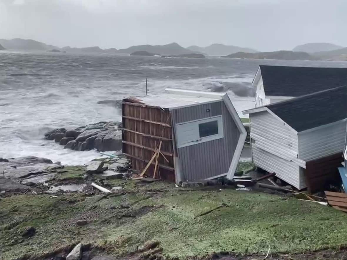
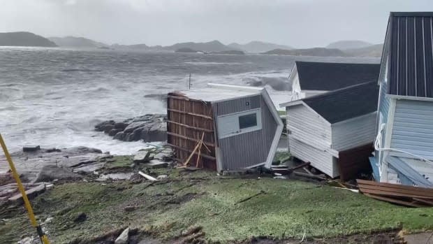
Post-tropical storm Fiona wreaked havoc on southwestern Newfoundland on Saturday.
Environment Canada meteorologist David Neil said the storm will continue moving northeast over the island through the day on Saturday and into southeastern Labrador by Sunday morning.
Neil said winds in the Wreckhouse were up to peak gusts of 178 km/h, and Port aux Basques, which is under a state of emergency, had peak winds of around 130 km/h.
"We're seeing some really strong winds especially more in southwestern Newfoundland, but we do expect strong winds to continue, really across the island," he said.
He said the strongest winds will be closer to the centre of Fiona, which will pass the west coast and travel to Labrador over the next day, and conditions will calm Saturday evening.
Tides are down from morning high tide, but Neil said evening high tide will pose a risk too. He advised residents to travel to higher ground if they're in dangerous low-lying areas.
"Fiona is not done yet," he warned.
Thousands without power
On Saturday afternoon, about 6,150 Newfoundland Power customers were without power from the Port aux Basques area through to Corner Brook, and as far east as Gambo Pond.
In a Facebook post, the Port aux Basques town council said the Bruce II Arena is open for anyone with pets who need shelter. Since town hall is inaccessible, a makeshift emergency command centre has been set up at the hospital.
In a tweet Saturday morning, Environment Canada said Port aux Basques has reported record high water levels and wind gusts to 134 km/h, and 168 km/h at Wreckhouse.
Environment Canada has issued storm surge, wind, rainfall, hurricane and tropical storm warnings for areas across the island.
On Saturday afternoon, the RCMP advised to avoid travelling on the Burgeo highway, Route 480, due to high winds.
In an interview with CBC News, RCMP Cpl. Jolene Garland pleaded with residents not to venture out into the storm to explore or take photos and video for social media.
'Damaging and devastating'
Early Saturday morning, Rob Carroll, a meteorologist with the Environment Canada weather office in Gander, said southwestern Newfoundland will see sustained winds of 100 km/h, gusting as high as 150 km/h to 180 km/h in the Wreckhouse area. Shortly before 6:30 a.m., the area had already seen 40 to 50 millimetres of rain. He said the area could see another 30 to 50 kilometres an hour over Saturday.
He said flooding is possible for areas along the south coast, but the risk is greater for areas further west.
"We're looking at waves crashing in at 10 to 15 metres and again, high storm surge combined with that. So, could be pretty damaging and devastating."
As the storm moves north, Carroll said winds will gust up to 130 km/h. He said southwest winds will gust up to 100 km/h this evening, before the weather calms overnight into Sunday. Central Labrador will see rain, and some areas in western Labrador could see snow.
He said eastern and central Newfoundland will see a mix of sun and cloud for most of the day, but winds will likely be strong, with some coastal areas on the Burin and Connaigre peninsulas seeing winds gusting up to 100 km/h.

