
Hit-or-miss storm risk makes for an uncertain Saturday in southwest Ontario
It’s one of those setups where a few kilometres will mean all the difference for folks across southwestern Ontario.
A system pushing through the U.S. Midwest will start to approach southwestern Ontario through the day on Saturday, potentially leading to a risk for thunderstorms during the afternoon and evening hours.
DON’T MISS: Global heat record smashed again for the third day this week

These storms will develop across the border and start to creep close to the international line later in the afternoon and around dinnertime.
The timing and precise placement of the storms will dictate whether or not they sweep over communities in southwestern Ontario, including Windsor, Chatham, Sarnia, and London.
Some models place the storms a little farther north, allowing them to cross into southwestern Ontario, while a few other models keep almost all of the activity stateside.
Two competing scenarios play out over the region
One potential setup would see a risk for severe weather build across southwestern Ontario.
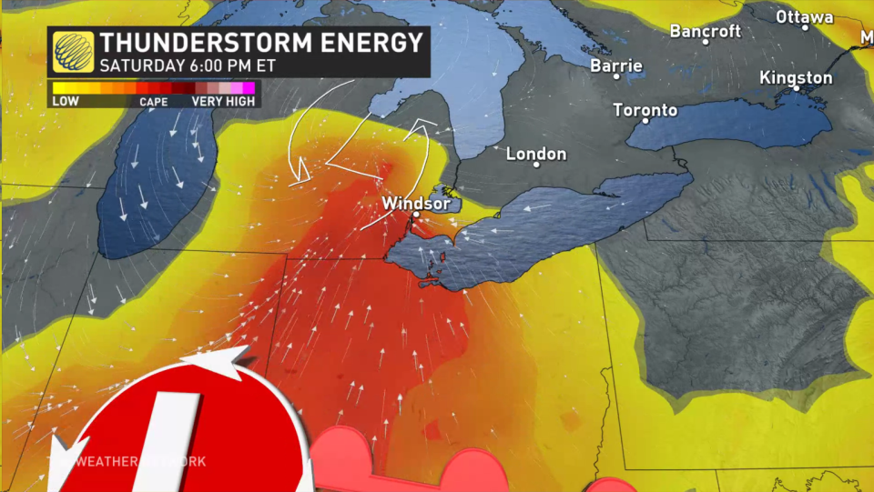
A centre of high pressure dominating southern Ontario on Saturday begins to break down as the system approaches the region, allowing clouds to build through the day. These clouds would limit daytime heating, but it would also allow that stateside low-pressure system to adjust its track farther north.
Some high-resolution models show a secondary low developing over Michigan, which would switch the wind direction and provide a trigger for thunderstorms to develop closer to home.

If this scenario plays out, the chance for severe thunderstorms would grow over southwestern Ontario, and the risk for straight-line winds and rotation would exist for some spots.
MUST SEE: Atlantic hurricane season may defy the odds with above-average activity
Other high-resolution models disagree with that setup, though, offering a low chance for showers instead. In this scenario, the high-pressure system is a bit stronger, keeping the area of low pressure south of the border.
Without this trigger for thunderstorms, the abundant instability over the Windsor area would go virtually untapped, leaving the area much drier than our stateside counterparts.

It’s the way things go during the summer months, unfortunately, as the exact location thunderstorms bubble up sometimes depends on lots of small-scale factors working together just right to turn a calm day hectic.
Either way, factor the potential for strong thunderstorms into your day on Saturday, hoping for the best but preparing for rough weather just in case.
Stay with The Weather Network into Saturday for the latest on this storm potential in southwestern Ontario.

