
P.E.I. officials urge Islanders to get ready as Hurricane Lee veers our way

As the P.E.I. Emergency Measures Organization takes steps to prepare for the arrival of Hurricane Lee, officials are encouraging Island citizens, groups and businesses to do the same.
"The best way to mitigate panic is to prepare," Nick Policelli, P.E.I.'s director of emergency management, said during a briefing Thursday afternoon.
The Emergency Measures Organization is in a Level One activation, meaning it has enhanced its monitoring, but officials stressed that this is not currently forecast to be a catastrophic storm on Prince Edward Island.
"It is very unlikely that this is anything close to a Fiona or a Dorian," said Policelli.
"We will learn more as we get into Saturday and into the weekend, and this is why we have only activated to a Level One."
Shelter beds ready
Extra shelter beds have been added in Montague, Charlottetown and Summerside in case people without adequate housing need them as the storm approaches.
P.E.I. Public Safety Minister Bloyce Thompson said the hours of operation will depend on the track and severity of the storm, but bedding supplies as well as food and water will be provided.
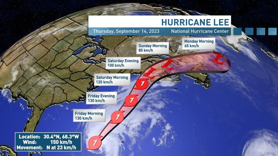
Hurricane Lee is now expected to make landfall in Nova Scotia. ( Jay Scotland/CBC News)
As for reception centres, Policelli said his staff is still confirming which facilities will be ready if needed.
"We reach out one by one by the telephone, the old school way of doing things, making sure it's getting done," he said. "We are making sure that, one, are they going to be open for people, and also, what services they can offer Islanders?"
The storm's forecast track has shifted to the east in the last 24 hours, and that could mean a bigger impact on Prince Edward Island.
"I don't want to scare anyone, but I do want everyone to be prepared," CBC meteorologist Tina Simpkin said Thursday. "This is still going to be a storm that we have to contend with."
Islanders should start feeling the impact of the storm Saturday afternoon. (Jay Scotland/CBC News)
Irving's tank farm is also getting ready just in case. A power outage at the tanks after post-tropical storm Fiona meant fuel could not be pumped into trucks for distribution across the province.
At Thursday's briefing, Thompson confirmed that a generator has arrived as a backup power source for this storm.
'This storm is a big storm'
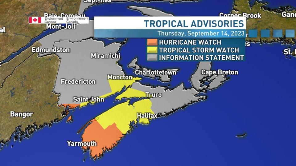
Wednesday morning's forecast had the storm making landfall somewhere close to the Maine-New Brunswick border, with the centre of the storm passing west of P.E.I. The updated forecast sees the storm brushing the western end of Nova Scotia, crossing the Bay of Fundy into New Brunswick, and passing over P.E.I.'s western Prince County.
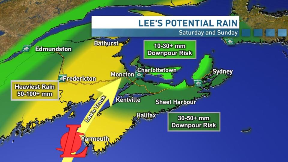
An updated forecast Thursday afternoon calls for rainfall between 10 and 30 millimetres in eastern P.E.I. (Jay Scotland/CBC)
"This storm is a big storm and it is going to bring us heavy rains and some high winds," said Simpkin.
An updated forecast Thursday afternoon calls for wind gusts between 60 and 90 km/h, with rainfall between 10 and 30 millimetres in eastern P.E.I., and 30 to 50 in the west. Rain amounts could be higher in downpours.
Still, the exact track of the storm remains uncertain. Environment and Climate Change Canada said it's continuing to monitor how things evolve, adding that the weather models are really starting to come together now.
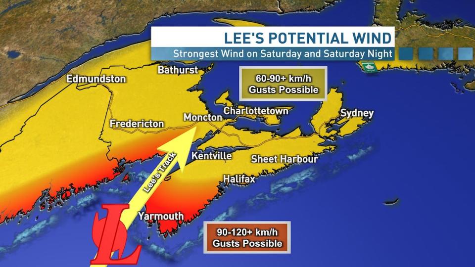
Wind gusts between 60 and 90 km/h possible Saturday and Saturday night. (Jay Scotland/CBC)
As of noon Thursday, the centre of the storm was about 1,650 km south-southwest of Halifax and moving north at 22 km/h.
Islanders should start feeling the impact of the storm Saturday afternoon, with wind and rain continuing into Sunday morning.

