
Plan ahead for slick roads in southern Ontario on New Year’s Eve
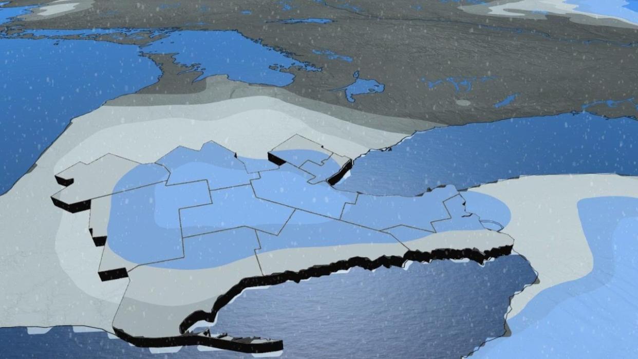
A clipper moving across the Great Lakes on Sunday will make for slippery roads across parts of southern Ontario as folks head out to celebrate New Year’s Eve.
The system will produce freezing drizzle and a potential dusting of snow, which could pose a hazard to drivers on an already busy night.
Take solace in next week’s forecast if you’re tired of the seemingly endless gloom. The sun will make its triumphant return soon enough.
DON’T MISS: Ontario saw some of Canada’s worst hailstorms in 2023

The best chance for snow begins Sunday afternoon in the southwest, including areas around the Golden Horseshoe as well as close to Windsor and Sarnia.
There’s also a risk for freezing drizzle ahead of this system, mainly above the escarpment toward Orangeville, Kitchener, and west toward Goderich. Freezing drizzle is light enough to efficiently leave a glaze of ice on exposed surfaces, which could make roads, sidewalks, and steps dangerously slippery.
Otherwise, the snow itself should prove more conversational than disruptive, adding a touch of natural festivity to the air as folks head out to celebrate the arrival of 2024.
Accumulations are a little tricky because much of this snow will melt on contact with the warm ground. Most of southern Ontario is on track to see a mere dusting on lawns and gardens. But use caution while travelling late Sunday night, as slick spots are likely to develop beneath any steadier snowfall.
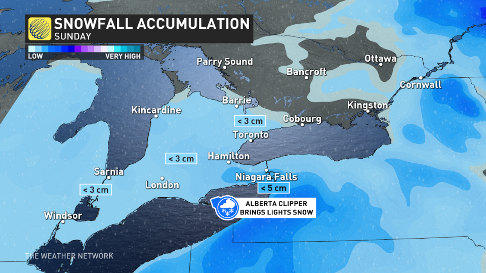
Folks hoping to see the New Year’s Eve fireworks at Niagara Falls may encounter the most snow from this system, but totals should remain under 5 cm.
GET THE FORECAST: Canada’s New Year’s Eve forecast is (mostly) good news for parties
If you’ve noted just how mild it’s been this December, you’re correct. Of the past 29 days recorded, 22 of them have been above normal, six of them near normal, and Dec. 6 was the only day to dip slightly below seasonal.
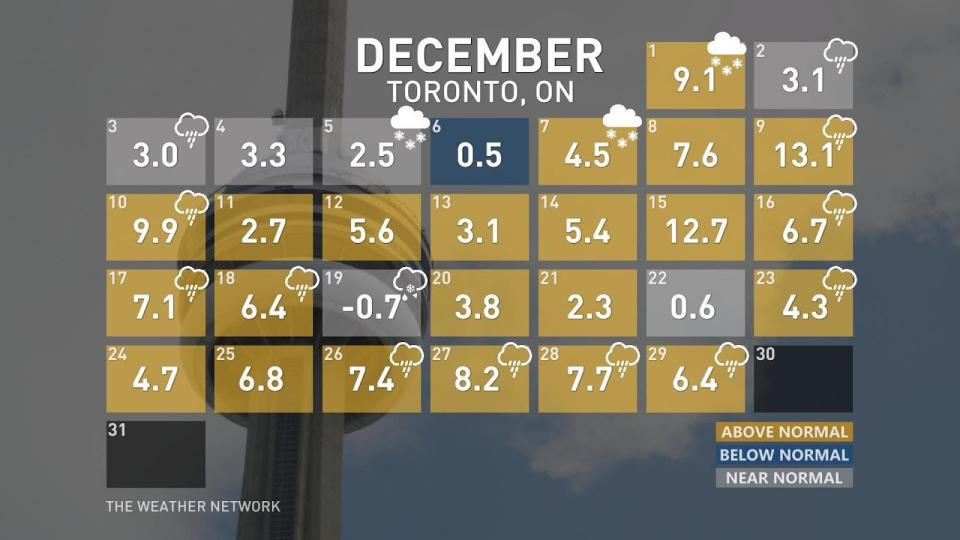
This is highly significant in terms of historical context. It will be the second warmest December on record for the City of Toronto, averaging a mean temperature of nearly 4 degrees. The all-time warmest December was 2015, with a mean temperature of 5 degrees.
As temperatures attempt to settle into a more seasonal range, the extended forecast features some bright spots if you’re sick of the persistent gloom that’s smothered southern Ontario through much of December. This has been Toronto’s cloudiest month since January, with about three full weeks of overcast or mostly cloudy skies hanging over the city.
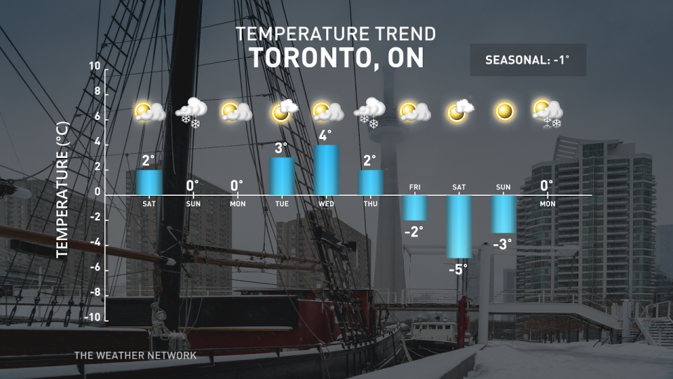
Cooler and sunnier conditions are on the horizon. A ridge moving over the Great Lakes on New Year’s Day will clear out the clouds and send temperatures rising a few degrees above seasonal for mid-week.
Tuesday looks to be the sunniest day of the week across the Greater Toronto Area, with seven hours of sunshine in the forecast and daytime highs climbing through the lower single digits.
Stay with The Weather Network for the latest on your forecast across Ontario.

