
High flood risk as storm may drop 200+ mm of rain on parts of East Coast
A powerful storm with subtropical moisture and strong winds is blasting through Atlantic Canada, with serious ramifications for power and travel this week.
WINTER 2024: El Niño will play a critical role in the weeks ahead
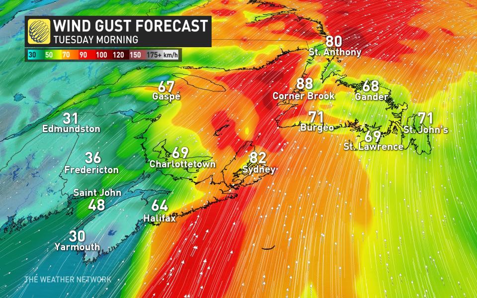
At the moment, thousands are without power across the Maritimes as intense wind gusts whip through the region. Winds are only expected to worsen Monday overnight, with peak gusts of 100+ km/h in some areas.
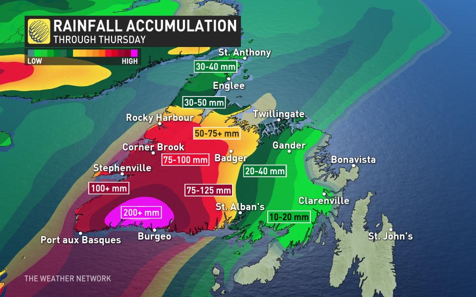
While the winds are a major issue, the rainfall is just as problematic. More than 100 mm of rainfall is possible in southeastern Nova Scotia. In southwestern Newfoundland, there is the potential for up to 200+ mm of rainfall through Thursday, so the risk for flash flooding is rather high.

(Nate Coleman/The Weather Network)
Widespread warnings are in effect with significant rain and damaging winds threatening a good portion of Atlantic Canada.
In fact, ECCC has some strong wording in Newfoundland about possible impacts. Similar storms in the past have caused numerous instances of flash flooding, fast-flowing water, often at levels exceeding river banks, washouts and closures of roads and bridges, interruption of transportation networks, strain on emergency response and public services, mudslides and landslides and lengthy recovery times, depending on nature of damage incurred.
This week: Travel and power disruptions occur, flood threat is heigtened
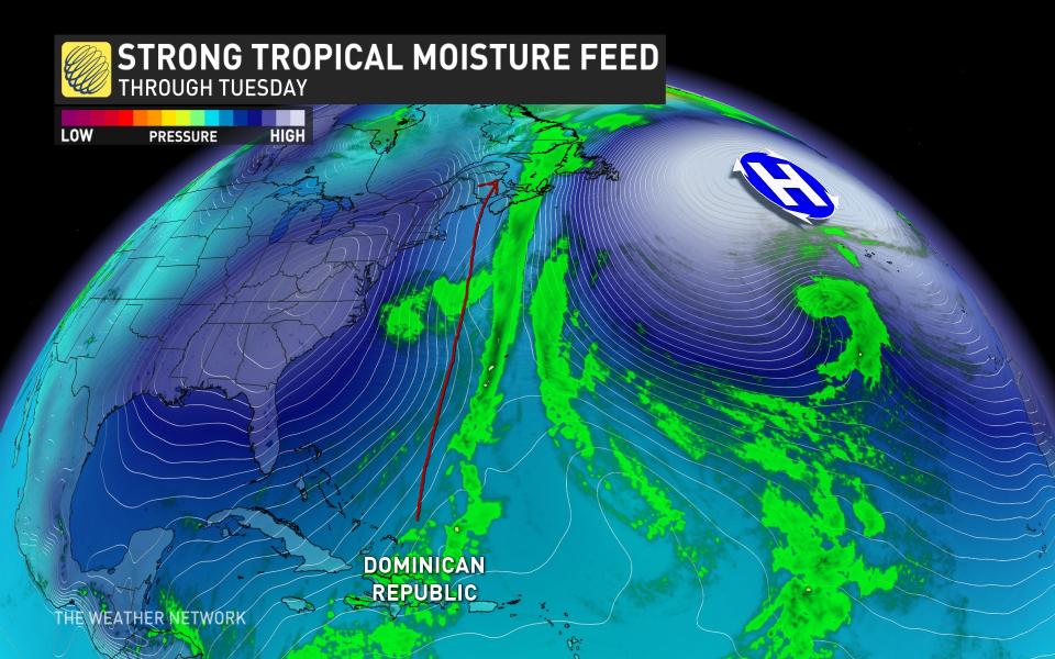
An extreme pattern in the atmosphere is going to lock an atmospheric river across the Maritimes through much of the week, as a strong high-pressure system funnels up moisture from as far south as the Dominican Republic.
Through Tuesday, the atmospheric river targets eastern Nova Scotia and southwestern Newfoundland, increasing the threat for flooding.
Monday’s heavy rain and gustiest winds in the Maritimes will subside for most, but will persist along a stationary front draped over eastern Nova Scotia and Newfoundland’s Burgeo shores.
Rain and wind will continue for the next 48 hours because of this unusually strong, wet and blocked setup. Rainfall totals are concerning with flooding threats especially in southwestern Newfoundland –– where 200+mm may wash through the region.
RELATED: Ferries cancelled, bridge restrictions possible in face of wind warning on P.E.I.
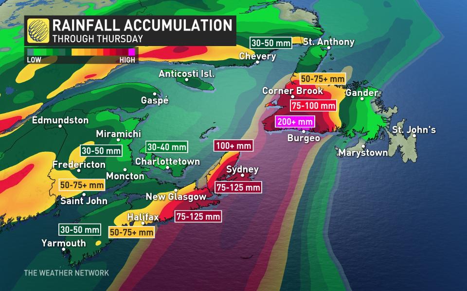
We’re watching areas east of Halifax to exceed 100 mm of rainfall by Wednesday, with widespread 50-75 mm of rainfall forecast across southwestern New Brunswick. Southwestern Newfoundland isn’t spared, either, as upwards of 200 mm + of rainfall is possible there through Thursday.
One of the many unusual aspects of this storm is that St. John’s will largely miss this system’s rain due to that ridge of high pressure over the ocean.
Another system is likely to affect the eastern Maritimes on Thursday. While confidence is low, that could pad rainfall totals through the week.
Winds will pose a serious issue during this storm on Monday into Tuesday. The extent and intensity of the gusts will rival the last storm. If you lost power in that storm, you may lose it again.
Widespread gusts of 80-100 km/h are likely across the Maritimes, with higher gusts possible along exposed coastal areas. That will likely lead to increasing amounts of power outages into Tuesday morning.
Ensure any outdoor holiday decorations are well-secured or brought inside before the winds begin. Inflatable characters and lightweight decor can take flight in winds half this strong, potentially causing damage, injuries, or even car accidents.
Remain mindful of large trees or tree limbs looming over homes, roads, and driveways, and take care to avoid those areas during the highest winds. Most wind-related injuries are caused by trees falling into buildings or vehicles.
A southerly wind will be ushered into Atlantic Canada, bringing several days of above-seasonal temperatures.
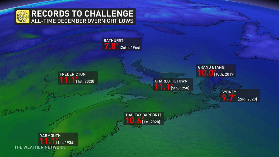
Seasonal temperatures in the Maritimes hover at or below the freezing mark for this time of year. However, through Tuesday, mild temperatures will dominate the region –– resulting in temperatures more than 10 degrees above seasonal at times. Monday overnight will be one to watch as temperatures may break all-time December records.
Stay with The Weather Network for the latest updates across Atlantic Canada.

