
Onslaught of western snow to prove a boon to ski resorts but cause perils for travelers


A pair of potent storms will dump some of the heaviest snow of the season thus far on the mountains, warn AccuWeather meteorologists.
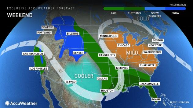
Snowfall across numerous mountain ranges in the West, especially the Sierra Nevada in California and the Rockies of Colorado, will end up being measured in feet. While this is great news for ski resorts and reservoirs in the region, it can make for dangerous travel conditions.
"Some major roads may close for a time, and secondary roads could become blocked with snow for days," said AccuWeather Senior Meteorologist Alex Sosnowski.
 |
The initial storm in the atmospheric river has already slammed into California, bringing heavy rain, mountain snow and strong winds to the state on Wednesday and Thursday. That storm will continue to advance inland across the interior West and will blanket the Rockies with snow into the weekend.
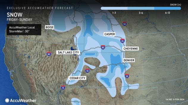
Mountain ranges from Arizona to Montana, including the Bitterroots, San Juans and Wasatch, will experience accumulating snow into the weekend as the storm moves through. The heaviest amounts are forecast to fall in the mountains of Wyoming and Colorado, where 6 inches to more than a foot can be expected.
The AccuWeather Local StormMax™ of 30 inches is most likely to occur in the Colorado Rockies. This puts the heaviest snow over some popular ski resorts, where large snowstorms have been few and far between this season. However, while snow-packed roads and slippery travel are to be expected on the highways that pass through the Rockies, motorists may encounter long segments of wintry conditions along Interstate 25 as well.
 |
According to OnTheSnow.com, the snowpack across Colorado is at only 54 percent of normal. Despite that, at least 71 percent of trails are open at popular ski resorts across the state, including 100 percent at Steamboat and Vail.
Despite the rosy prospect for the ski resorts, this storm will do little to curb the snow droughts in both Denver and Salt Lake City, where less than an inch is forecast to fall. So far this season, the Mile High City has recorded only 16 inches through the end of January, only 61 percent of the historical average to date of 26.1 inches. The drought is even more notable in Salt Lake City, where just 17.2 inches has fallen versus the historical average to date of 32.3 inches (only 53 percent of average).
While travel in major metropolitan areas may be impacted little by the snow, that will not be the case for those venturing over the mountain ranges. Driving along portions of Interstates 40, 70, 80 and 90 could prove a tricky prospect through the passes, where snow chains may be recommended by local officials. In addition, reduced visibility can impact air travel through the region.
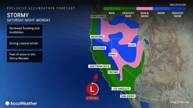
Mere days after the first storm socks the mountains of California, the next one will arrive with even more ferocity later this weekend and into next week, and snow in the Sierra Nevada will end up being measured with yardsticks, warn AccuWeather experts.
 |
"Unlike the first storm, the next one will produce a much longer period of substantial precipitation [in California]," said AccuWeather California Expert Ken Clark. In the higher elevations, this means snow measured in feet.
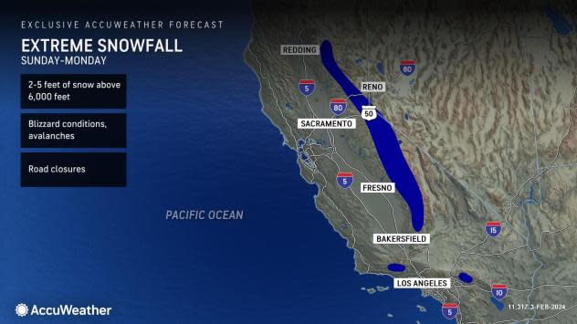
In the Sierra Nevada range, Clark is expecting 3-5 feet of snow to accumulate at resort level, with 1-3 feet even possible down to 5,000 feet in elevation. In the mountains of Southern California, 2-4 feet can accumulate at resort levels there, with even a foot or more down to pass levels, despite a period of rain.
 |
"Road closures are likely in all of the mountain ranges, even in Southern California," added Clark. "Passes leading into or out of SoCal can shut down as well, from Monday night through Wednesday."
Because of the expected heavy snow, Clark is sounding the warning bells for those who live in the mountains of the southern part of the state. "If you live near the resorts in Southern California, plan now to be unable to get out of your area for an extended amount of time," said Clark.
In addition to the heavy snow, there can be powerful winds, which can create blizzard conditions. The first storm generated a wind gust of 100 mph on Ward Mountain and 99 mph on Mammoth Mountain in California on Wednesday, and the next storm can generate similar, if not stronger, wind gusts.
 |
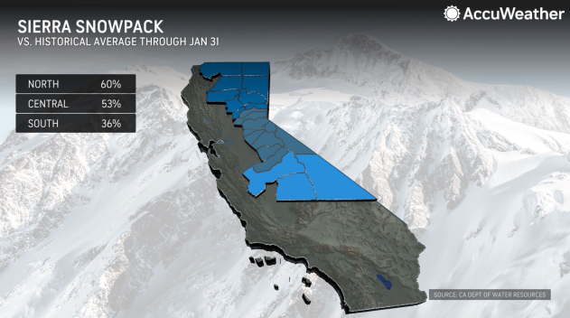
While the short-term implications of the heavy snow and strong winds are negative, the long-term benefits will be positive. The percent of water locked up in the snowpack of the Sierra is only about half of the historical average for the date and just 31 percent for an entire water year, according to California's Department of Water Resources. The prospect of heavy snow, which will eventually melt and fill the state's reservoirs, is surely a plus.
Want next-level safety, ad-free? Unlock advanced, hyperlocal severe weather alerts when you subscribe to Premium+ on the AccuWeather app. AccuWeather Alerts™ are prompted by our expert meteorologists who monitor and analyze dangerous weather risks 24/7 to keep you and your family safer.
