
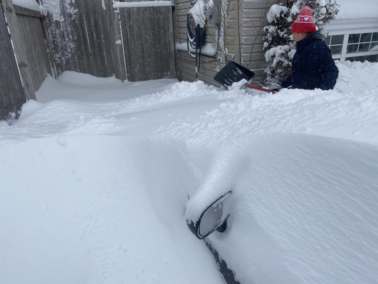
PHOTOS: 'Blockbuster' East Coast storm is bringing historic snowfall
An unusual, stalling low-pressure system dancing off the coast of Nova Scotia is bringing the highest snowfall totals seen in two decades for a big swath of Atlantic Canada.
A low-pressure system has hit the pause button and is stalling just southeast of Sable Island for 48 hours. An Arctic high over Labrador is supplying the cold air, resulting in a blockbuster snowfall event for those in the eastern Maritimes and central Newfoundland.
MUST SEE: El Niño and the polar vortex take centre stage for winter’s final chapter
Confidence is greatest that Cape Breton and parts of Newfoundland will see the most substantial snowfall totals by the time snow finally stops early this week.
As a result, more than 4,400 Nova Scotia Power customers are in the dark as of Sunday morning. That will likely fluctuate through the duration of the storm.
Hwy 221 between Gibson Wood Road and Middle Dyke Road in #Sheffield Mills, NS is closed in both directions due to heavy snowfall. The road is expected to be closed for a number of hours. Avoid unnecessary travel and call 511 or follow @511ns for the latest road conditions. pic.twitter.com/JCiUywfyPU
Hwy 221 between Gibson Wood Road and Middle Dyke Road in RCMP Nova Scotia on Twitter: "Hwy 221 between Gibson Wood Road and Middle Dyke Road in #Sheffield Mills, NS is closed in both directions due to heavy snowfall. The road is expected to be closed for a number of hours. Avoid unnecessary travel and call 511 or follow @511ns for the latest road conditions. pic.twitter.com/JCiUywfyPU / Twitter" Mills, NS is closed in both directions due to heavy snowfall. The road is expected to be closed for a number of hours. Avoid unnecessary travel and call 511 or follow RCMP Nova Scotia on Twitter: "Hwy 221 between Gibson Wood Road and Middle Dyke Road in #Sheffield Mills, NS is closed in both directions due to heavy snowfall. The road is expected to be closed for a number of hours. Avoid unnecessary travel and call 511 or follow @511ns for the latest road conditions. pic.twitter.com/JCiUywfyPU / Twitter" for the latest road conditions. RCMP Nova Scotia on Twitter: "Hwy 221 between Gibson Wood Road and Middle Dyke Road in #Sheffield Mills, NS is closed in both directions due to heavy snowfall. The road is expected to be closed for a number of hours. Avoid unnecessary travel and call 511 or follow @511ns for the latest road conditions. pic.twitter.com/JCiUywfyPU / Twitter"
There have also been numerous road, school and business closures in Atlantic Canada, as well. Transit and flight delays and cancellations have occurred, too, as a result of the marathon snow. The Nova Scotia government and RCMP are urging people to stay off the roads, unless their travel is essential.
Besides the road closures, there have also been numerous collisions reported.
Cape Breton Regional Municipality has declared a local state of emergency for the next seven days due to the overwhelming amount of snow.
There have also been widespread school closure announcements across Nova Scotia for Monday as it is unlikely the snow will be cleared in time.
WATCH: When does a snowstorm become a blizzard?
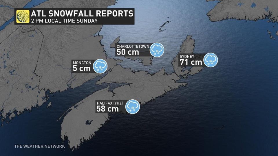
Preliminary snowfall totals as of 2 p.m. local time Sunday include more than 55 cm at Halifax airport, more than 70 cm in Sydney and more than 50 cm in Charlottetown. However, there are reports around Sydney of even greater snowfall. The airport could have inaccurate totals with blowing and drifting snow, and using melted snow.
Sydney, Antigonish, New Glasgow and eastern P.E.I. have seen snowfall rates as high as 2-3 centimetres an hour and blizzard conditions.
A heavy band of snowfall first set up along Nova Scotia Saturday, creating dangerously low visibility and heavy snowfall rates. Exposed sections of coastline were forecast to see winds exceeding 70 km/h.
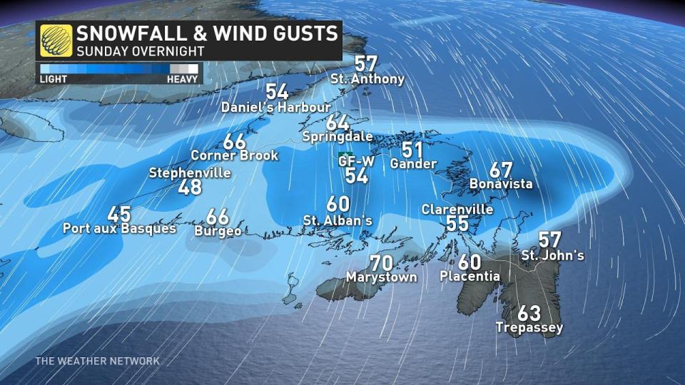
Cape Breton, N.S., is forecast to see some of the worst conditions, with heavy snow and wind gusts of 50-70 km/h, creating blizzard conditions. Winds in Newfoundland are expected to hit 60-80 km/h.
Bands of locally heavy snowfall pulled into central Newfoundland Saturday afternoon, along with gusty northeasterly winds, but the Avalon has been, and will be, largely spared from significant impacts.
KNOW THE SIGNS: How shovelling heavy snow can lead to heart attacks
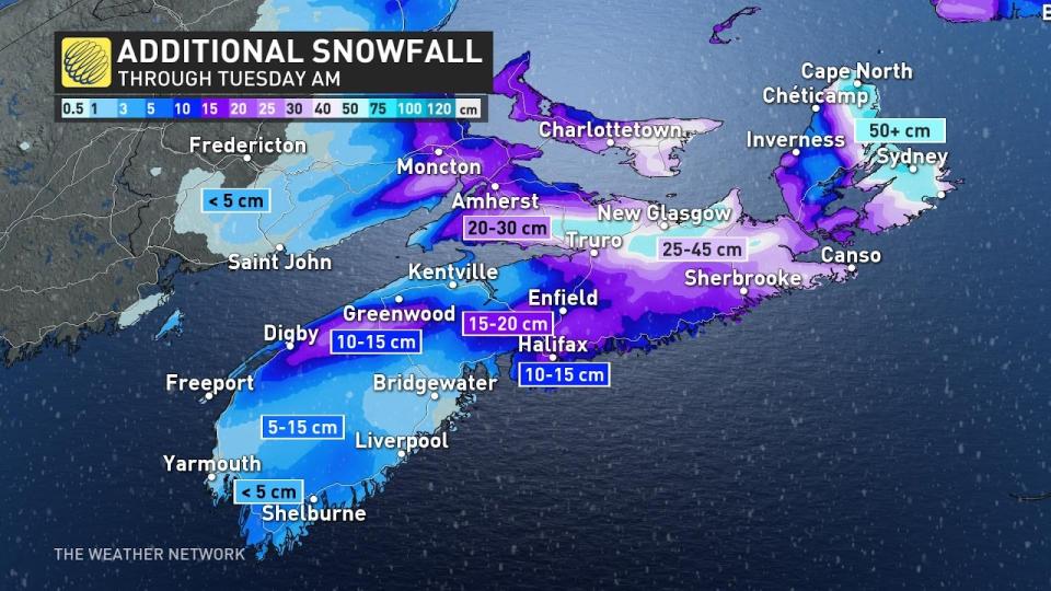
Snow was beginning to pile up in Sydney, with over half a metre reported through Sunday morning, with locally higher amounts documented. An additional 50+ cm of snow is forecast for the area, meaning this is likely going to be the most significant snowfall event in recorded history for Cape Breton.
East of Truro, along Highway 104, is where the totals really pile up past half a metre of snowfall. Travel will be impossible throughout the region on Sunday with intense drifts and zero visibility.
The Cape Breton region, including Sydney, and Glace Bay, is forecast to have more than 100 cm of snowfall accumulation. With these snowfall rates forecast, a long-duration blizzard is likely to linger through much of Sunday.
When all is said and done, some regions are likely to record up to 150 cm of snowfall accumulation in localized spots.
Although the Avalon is a tricky forecast with two waves of snowfall forecast for St. John’s, resulting in more than 20 cm of snow forecast through Tuesday. Farther inland, and west along the Trans-Canada Highway, expect 20-40 cm of snow from Gander to Deer Lake.
The storm will eventually weaken and depart the area later Tuesday.
Below is a selection of visuals of the prolonged storm circulating on social media.
There used to be a truck here... somewhere. #NSStorm pic.twitter.com/3OykUP4Hvi
There used to be a truck here... somewhere. ☃️❄️ on Twitter: "There used to be a truck here... somewhere. #NSStorm pic.twitter.com/3OykUP4Hvi / Twitter" ☃️❄️ on Twitter: "There used to be a truck here... somewhere. #NSStorm pic.twitter.com/3OykUP4Hvi / Twitter"
— ☃️❄️ (@abitofstrange) ☃️❄️ on Twitter: "There used to be a truck here... somewhere. #NSStorm pic.twitter.com/3OykUP4Hvi / Twitter"
You know it's a bad or good #NSStorm when you have to do this to find your vehicle. This is my sister in Sydney River Cape Breton digging through about 100+cms of snow pic.twitter.com/jgDjXDKWd9
You know it’s a bad or good East Coast Drone man on Twitter: "You know it's a bad or good #NSStorm when you have to do this to find your vehicle. This is my sister in Sydney River Cape Breton digging through about 100+cms of snow pic.twitter.com/jgDjXDKWd9 / Twitter" when you have to do this to find your vehicle.
This is my sister in Sydney River Cape Breton digging through about 100+cms of snow East Coast Drone man on Twitter: "You know it's a bad or good #NSStorm when you have to do this to find your vehicle. This is my sister in Sydney River Cape Breton digging through about 100+cms of snow pic.twitter.com/jgDjXDKWd9 / Twitter"— East Coast Drone man (@eastcoastdrone) East Coast Drone man on Twitter: "You know it's a bad or good #NSStorm when you have to do this to find your vehicle. This is my sister in Sydney River Cape Breton digging through about 100+cms of snow pic.twitter.com/jgDjXDKWd9 / Twitter"
About 5 feet of snow so far and it's still coming down. ❄️Sydney, Cape Breton Island, Nova Scotia#NSStorm pic.twitter.com/oL0ClAXOmU
About 5 feet of snow so far and it’s still coming down. ❄️
Sydney, Cape Breton Island, Nova ScotiaChuck Wrathall on Twitter: "About 5 feet of snow so far and it's still coming down. ❄️Sydney, Cape Breton Island, Nova Scotia#NSStorm pic.twitter.com/oL0ClAXOmU / Twitter" Chuck Wrathall on Twitter: "About 5 feet of snow so far and it's still coming down. ❄️Sydney, Cape Breton Island, Nova Scotia#NSStorm pic.twitter.com/oL0ClAXOmU / Twitter"— Chuck Wrathall (@ChuckWrathall) Chuck Wrathall on Twitter: "About 5 feet of snow so far and it's still coming down. ❄️Sydney, Cape Breton Island, Nova Scotia#NSStorm pic.twitter.com/oL0ClAXOmU / Twitter"
Good morning. More snow. #NSstorm. Power is still on, so thats good. pic.twitter.com/KG8I78PnOl
Good morning. More snow. chrisannad (parody party?) also on the blue one on Twitter: "Good morning. More snow. #NSstorm. Power is still on, so thats good. pic.twitter.com/KG8I78PnOl / Twitter". Power is still on, so thats good. chrisannad (parody party?) also on the blue one on Twitter: "Good morning. More snow. #NSstorm. Power is still on, so thats good. pic.twitter.com/KG8I78PnOl / Twitter"
— chrisannad (parody party?) also on the blue one (@chrisannad) chrisannad (parody party?) also on the blue one on Twitter: "Good morning. More snow. #NSstorm. Power is still on, so thats good. pic.twitter.com/KG8I78PnOl / Twitter"
The Mayor and Council have declared a local state of emergency in Sydney, Cape Breton. There's so much snow, the plows can't keep up. #NSStorm 📸 @DMac57068291 pic.twitter.com/3FR107OF29
The Mayor and Council have declared a local state of emergency in Sydney, Cape Breton. There’s so much snow, the plows can’t keep up. Kim MacDonald 🌻 on Twitter: "The Mayor and Council have declared a local state of emergency in Sydney, Cape Breton. There's so much snow, the plows can't keep up. #NSStorm 📸 @DMac57068291 pic.twitter.com/3FR107OF29 / Twitter" 📸 Kim MacDonald 🌻 on Twitter: "The Mayor and Council have declared a local state of emergency in Sydney, Cape Breton. There's so much snow, the plows can't keep up. #NSStorm 📸 @DMac57068291 pic.twitter.com/3FR107OF29 / Twitter" Kim MacDonald 🌻 on Twitter: "The Mayor and Council have declared a local state of emergency in Sydney, Cape Breton. There's so much snow, the plows can't keep up. #NSStorm 📸 @DMac57068291 pic.twitter.com/3FR107OF29 / Twitter"
— Kim MacDonald 🌻 (@KMacTWN) Kim MacDonald 🌻 on Twitter: "The Mayor and Council have declared a local state of emergency in Sydney, Cape Breton. There's so much snow, the plows can't keep up. #NSStorm 📸 @DMac57068291 pic.twitter.com/3FR107OF29 / Twitter"
Taken through the window. I opened the door and shut it immediately lol. It's nasty out there!#NSStorm #CapeBreton pic.twitter.com/tqBHv7Ln98
Taken through the window. I opened the door and shut it immediately lol.
It's nasty out there!Kate Wright 🌻 on Twitter: "Taken through the window. I opened the door and shut it immediately lol. It's nasty out there!#NSStorm #CapeBreton pic.twitter.com/tqBHv7Ln98 / Twitter" Kate Wright 🌻 on Twitter: "Taken through the window. I opened the door and shut it immediately lol. It's nasty out there!#NSStorm #CapeBreton pic.twitter.com/tqBHv7Ln98 / Twitter" Kate Wright 🌻 on Twitter: "Taken through the window. I opened the door and shut it immediately lol. It's nasty out there!#NSStorm #CapeBreton pic.twitter.com/tqBHv7Ln98 / Twitter"— Kate Wright 🌻 (@KatezRight) Kate Wright 🌻 on Twitter: "Taken through the window. I opened the door and shut it immediately lol. It's nasty out there!#NSStorm #CapeBreton pic.twitter.com/tqBHv7Ln98 / Twitter"
Lots of this happening around Sydney today. Expecting 60-80cm of snow by Sunday night in parts of Cape Breton. #NSStorm #EastlinkCommunityTV pic.twitter.com/sB4hzIzng0
Lots of this happening around Sydney today. Expecting 60-80cm of snow by Sunday night in parts of Cape Breton. Cory McGraw on Twitter: "Lots of this happening around Sydney today. Expecting 60-80cm of snow by Sunday night in parts of Cape Breton. #NSStorm #EastlinkCommunityTV pic.twitter.com/sB4hzIzng0 / Twitter" Cory McGraw on Twitter: "Lots of this happening around Sydney today. Expecting 60-80cm of snow by Sunday night in parts of Cape Breton. #NSStorm #EastlinkCommunityTV pic.twitter.com/sB4hzIzng0 / Twitter" Cory McGraw on Twitter: "Lots of this happening around Sydney today. Expecting 60-80cm of snow by Sunday night in parts of Cape Breton. #NSStorm #EastlinkCommunityTV pic.twitter.com/sB4hzIzng0 / Twitter"
— Cory McGraw (@McgrawCory) Cory McGraw on Twitter: "Lots of this happening around Sydney today. Expecting 60-80cm of snow by Sunday night in parts of Cape Breton. #NSStorm #EastlinkCommunityTV pic.twitter.com/sB4hzIzng0 / Twitter"
Sydney update at 10am:Front and back of the house. The driveway was cleared twice yesterday ( including evening ) with a snow blower. You wouldn't think it was touched. For the record, that's a GMC Terrain that's buried. That ain't so small SUV 😬#NSStorm pic.twitter.com/0ZSbIDMUfM
Sydney update at 10am:
Front and back of the house. The driveway was cleared twice yesterday ( including evening ) with a snow blower. You wouldn’t think it was touched. For the record, that’s a GMC Terrain that’s buried. That ain’t so small SUV 😬🪷✨ Ⓐᗰ𝐲 ✨🪷 Single gal era 💃💁♀️ on Twitter: "Sydney update at 10am:Front and back of the house. The driveway was cleared twice yesterday ( including evening ) with a snow blower. You wouldn't think it was touched. For the record, that's a GMC Terrain that's buried. That ain't so small SUV 😬#NSStorm pic.twitter.com/0ZSbIDMUfM / Twitter" 🪷✨ Ⓐᗰ𝐲 ✨🪷 Single gal era 💃💁♀️ on Twitter: "Sydney update at 10am:Front and back of the house. The driveway was cleared twice yesterday ( including evening ) with a snow blower. You wouldn't think it was touched. For the record, that's a GMC Terrain that's buried. That ain't so small SUV 😬#NSStorm pic.twitter.com/0ZSbIDMUfM / Twitter"— 🪷✨ Ⓐᗰ𝐲 ✨🪷 Single gal era 💃💁♀️ (@girlindabushes) 🪷✨ Ⓐᗰ𝐲 ✨🪷 Single gal era 💃💁♀️ on Twitter: "Sydney update at 10am:Front and back of the house. The driveway was cleared twice yesterday ( including evening ) with a snow blower. You wouldn't think it was touched. For the record, that's a GMC Terrain that's buried. That ain't so small SUV 😬#NSStorm pic.twitter.com/0ZSbIDMUfM / Twitter"
It's nice to see one of my boys helping his dad shovel. It's like seeing a unicorn lol#NSStorm #NovaScotia #snow ❄️ ⛄️ pic.twitter.com/bnMhbJO4H9
It’s nice to see one of my boys helping his dad shovel. It’s like seeing a unicorn lolL.A Bowden on Twitter: "It's nice to see one of my boys helping his dad shovel. It's like seeing a unicorn lol#NSStorm #NovaScotia #snow ❄️ ⛄️ pic.twitter.com/bnMhbJO4H9 / Twitter" L.A Bowden on Twitter: "It's nice to see one of my boys helping his dad shovel. It's like seeing a unicorn lol#NSStorm #NovaScotia #snow ❄️ ⛄️ pic.twitter.com/bnMhbJO4H9 / Twitter" L.A Bowden on Twitter: "It's nice to see one of my boys helping his dad shovel. It's like seeing a unicorn lol#NSStorm #NovaScotia #snow ❄️ ⛄️ pic.twitter.com/bnMhbJO4H9 / Twitter" ❄️ ⛄️ L.A Bowden on Twitter: "It's nice to see one of my boys helping his dad shovel. It's like seeing a unicorn lol#NSStorm #NovaScotia #snow ❄️ ⛄️ pic.twitter.com/bnMhbJO4H9 / Twitter"
— L.A Bowden (@bowden2you) L.A Bowden on Twitter: "It's nice to see one of my boys helping his dad shovel. It's like seeing a unicorn lol#NSStorm #NovaScotia #snow ❄️ ⛄️ pic.twitter.com/bnMhbJO4H9 / Twitter"
Current conditions in #Halifax Your snow story continues this morning @weathernetwork I'm live with @MattHamelTV It's starting to feel like Groundhog Day...#nsstorm pic.twitter.com/209AN8jc56
Current conditions in Nathan Coleman on Twitter: "Current conditions in #Halifax Your snow story continues this morning @weathernetwork I'm live with @MattHamelTV It's starting to feel like Groundhog Day...#nsstorm pic.twitter.com/209AN8jc56 / Twitter" Your snow story continues this morning Nathan Coleman on Twitter: "Current conditions in #Halifax Your snow story continues this morning @weathernetwork I'm live with @MattHamelTV It's starting to feel like Groundhog Day...#nsstorm pic.twitter.com/209AN8jc56 / Twitter" I’m live with Nathan Coleman on Twitter: "Current conditions in #Halifax Your snow story continues this morning @weathernetwork I'm live with @MattHamelTV It's starting to feel like Groundhog Day...#nsstorm pic.twitter.com/209AN8jc56 / Twitter" It’s starting to feel like Groundhog Day…Nathan Coleman on Twitter: "Current conditions in #Halifax Your snow story continues this morning @weathernetwork I'm live with @MattHamelTV It's starting to feel like Groundhog Day...#nsstorm pic.twitter.com/209AN8jc56 / Twitter" Nathan Coleman on Twitter: "Current conditions in #Halifax Your snow story continues this morning @weathernetwork I'm live with @MattHamelTV It's starting to feel like Groundhog Day...#nsstorm pic.twitter.com/209AN8jc56 / Twitter"
— Nathan Coleman (@NateTWN) Nathan Coleman on Twitter: "Current conditions in #Halifax Your snow story continues this morning @weathernetwork I'm live with @MattHamelTV It's starting to feel like Groundhog Day...#nsstorm pic.twitter.com/209AN8jc56 / Twitter"
Absolutely vicious bands continue to lash Cape Breton island early this AM where visibility has essentially become non-existent #NSstorm #NLstorm pic.twitter.com/g1nqEHIJkS
Absolutely vicious bands continue to lash Cape Breton island early this AM where visibility has essentially become non-existent Dylan on Twitter: "Absolutely vicious bands continue to lash Cape Breton island early this AM where visibility has essentially become non-existent #NSstorm #NLstorm pic.twitter.com/g1nqEHIJkS / Twitter" Dylan on Twitter: "Absolutely vicious bands continue to lash Cape Breton island early this AM where visibility has essentially become non-existent #NSstorm #NLstorm pic.twitter.com/g1nqEHIJkS / Twitter" Dylan on Twitter: "Absolutely vicious bands continue to lash Cape Breton island early this AM where visibility has essentially become non-existent #NSstorm #NLstorm pic.twitter.com/g1nqEHIJkS / Twitter"
— Dylan (@Dylan_Hurleyh2) Dylan on Twitter: "Absolutely vicious bands continue to lash Cape Breton island early this AM where visibility has essentially become non-existent #NSstorm #NLstorm pic.twitter.com/g1nqEHIJkS / Twitter"
This isn't even the Main Event - that's coming tomorrow 🫣😳❄️ #NSStorm #Unamaki pic.twitter.com/N971SEhavl
This isn’t even the Main Event - that’s coming tomorrow 🫣😳❄️ Trevor Bernard 🦝 on Twitter: "This isn't even the Main Event - that's coming tomorrow 🫣😳❄️ #NSStorm #Unamaki pic.twitter.com/N971SEhavl / Twitter" Trevor Bernard 🦝 on Twitter: "This isn't even the Main Event - that's coming tomorrow 🫣😳❄️ #NSStorm #Unamaki pic.twitter.com/N971SEhavl / Twitter" Trevor Bernard 🦝 on Twitter: "This isn't even the Main Event - that's coming tomorrow 🫣😳❄️ #NSStorm #Unamaki pic.twitter.com/N971SEhavl / Twitter"
— Trevor Bernard 🦝 (@mb2law) Trevor Bernard 🦝 on Twitter: "This isn't even the Main Event - that's coming tomorrow 🫣😳❄️ #NSStorm #Unamaki pic.twitter.com/N971SEhavl / Twitter"
Blowing snow downtown Halifax #nsstorm It'll be worse in Sydney @RachelSchoutsen @weathernetwork pic.twitter.com/mCgQEQOzWN
Blowing snow downtown Halifax Nathan Coleman on Twitter: "Blowing snow downtown Halifax #nsstorm It'll be worse in Sydney @RachelSchoutsen @weathernetwork pic.twitter.com/mCgQEQOzWN / Twitter" It’ll be worse in Sydney Nathan Coleman on Twitter: "Blowing snow downtown Halifax #nsstorm It'll be worse in Sydney @RachelSchoutsen @weathernetwork pic.twitter.com/mCgQEQOzWN / Twitter" Nathan Coleman on Twitter: "Blowing snow downtown Halifax #nsstorm It'll be worse in Sydney @RachelSchoutsen @weathernetwork pic.twitter.com/mCgQEQOzWN / Twitter" Nathan Coleman on Twitter: "Blowing snow downtown Halifax #nsstorm It'll be worse in Sydney @RachelSchoutsen @weathernetwork pic.twitter.com/mCgQEQOzWN / Twitter"
— Nathan Coleman (@NateTWN) Nathan Coleman on Twitter: "Blowing snow downtown Halifax #nsstorm It'll be worse in Sydney @RachelSchoutsen @weathernetwork pic.twitter.com/mCgQEQOzWN / Twitter"
My pathway lol #NSStorm #NovaScotia 😵💫😵💫❄️❄️ pic.twitter.com/1racBIPX5J
My pathway lol Cheryl in Nova Scotia 🍁🇨🇦🦞 on Twitter: "My pathway lol #NSStorm #NovaScotia 😵💫😵💫❄️❄️ pic.twitter.com/1racBIPX5J / Twitter" Cheryl in Nova Scotia 🍁🇨🇦🦞 on Twitter: "My pathway lol #NSStorm #NovaScotia 😵💫😵💫❄️❄️ pic.twitter.com/1racBIPX5J / Twitter" 😵💫😵💫❄️❄️ Cheryl in Nova Scotia 🍁🇨🇦🦞 on Twitter: "My pathway lol #NSStorm #NovaScotia 😵💫😵💫❄️❄️ pic.twitter.com/1racBIPX5J / Twitter"
— Cheryl in Nova Scotia 🍁🇨🇦🦞 (@mini_bubbly) Cheryl in Nova Scotia 🍁🇨🇦🦞 on Twitter: "My pathway lol #NSStorm #NovaScotia 😵💫😵💫❄️❄️ pic.twitter.com/1racBIPX5J / Twitter"
Big Bras dor Nova Scotia #NSStorm pic.twitter.com/DwhIICqxDQ
Big Bras dor Nova Scotia Tracy Hofman on Twitter: "Big Bras dor Nova Scotia #NSStorm pic.twitter.com/DwhIICqxDQ / Twitter" Tracy Hofman on Twitter: "Big Bras dor Nova Scotia #NSStorm pic.twitter.com/DwhIICqxDQ / Twitter"
— Tracy Hofman (@tracy_hofman) Tracy Hofman on Twitter: "Big Bras dor Nova Scotia #NSStorm pic.twitter.com/DwhIICqxDQ / Twitter"
Current scenery in Pictou, N.S. Photos courtesy of my friend's mom. #NSStorm #NSwx pic.twitter.com/YkV1NMPtaJ
Current scenery in Pictou, N.S. Photos courtesy of my friend’s mom. Nathan Howes TWN on Twitter: "Current scenery in Pictou, N.S. Photos courtesy of my friend's mom. #NSStorm #NSwx pic.twitter.com/YkV1NMPtaJ / Twitter" Nathan Howes TWN on Twitter: "Current scenery in Pictou, N.S. Photos courtesy of my friend's mom. #NSStorm #NSwx pic.twitter.com/YkV1NMPtaJ / Twitter" Nathan Howes TWN on Twitter: "Current scenery in Pictou, N.S. Photos courtesy of my friend's mom. #NSStorm #NSwx pic.twitter.com/YkV1NMPtaJ / Twitter"
— Nathan Howes TWN (@HowesNathan) Nathan Howes TWN on Twitter: "Current scenery in Pictou, N.S. Photos courtesy of my friend's mom. #NSStorm #NSwx pic.twitter.com/YkV1NMPtaJ / Twitter"
Some more Pictou pictures. pic.twitter.com/Kv22UXPiwE
Some more Pictou pictures. Chantal LeBlanc on Twitter: "Some more Pictou pictures. pic.twitter.com/Kv22UXPiwE / Twitter"
— Chantal LeBlanc (@Chantal_1022) Chantal LeBlanc on Twitter: "Some more Pictou pictures. pic.twitter.com/Kv22UXPiwE / Twitter"
Took a stroll. Lots of snow. Not many people. #nsstorm pic.twitter.com/8Ztkv3cmWa
Took a stroll. Lots of snow. Not many people. Bev Phillips on Twitter: "Took a stroll. Lots of snow. Not many people. #nsstorm pic.twitter.com/8Ztkv3cmWa / Twitter" Bev Phillips on Twitter: "Took a stroll. Lots of snow. Not many people. #nsstorm pic.twitter.com/8Ztkv3cmWa / Twitter"
— Bev Phillips (@BevJPhillips) Bev Phillips on Twitter: "Took a stroll. Lots of snow. Not many people. #nsstorm pic.twitter.com/8Ztkv3cmWa / Twitter"
Navigating the sidewalks right now #Halifax #nsstorm @RachelSchoutsen pic.twitter.com/9HI1CjtEVu
Navigating the sidewalks right now Nathan Coleman on Twitter: "Navigating the sidewalks right now #Halifax #nsstorm @RachelSchoutsen pic.twitter.com/9HI1CjtEVu / Twitter" Nathan Coleman on Twitter: "Navigating the sidewalks right now #Halifax #nsstorm @RachelSchoutsen pic.twitter.com/9HI1CjtEVu / Twitter" Nathan Coleman on Twitter: "Navigating the sidewalks right now #Halifax #nsstorm @RachelSchoutsen pic.twitter.com/9HI1CjtEVu / Twitter" Nathan Coleman on Twitter: "Navigating the sidewalks right now #Halifax #nsstorm @RachelSchoutsen pic.twitter.com/9HI1CjtEVu / Twitter"
— Nathan Coleman (@NateTWN) Nathan Coleman on Twitter: "Navigating the sidewalks right now #Halifax #nsstorm @RachelSchoutsen pic.twitter.com/9HI1CjtEVu / Twitter"
Snowy day Englishtown #CapeBreton NNE30 km/hr gust to 50 increasing slowly all day Visibility under a Km and decreasing fast Put an other log on fire and relax be safe #nsstorm @KalinMitchelCTV @ryansnoddon @RyanMacD_CTV @NateTWN pic.twitter.com/VmIrcx2DGQ
Snowy day Englishtown Nelson Edge on Twitter: "Snowy day Englishtown #CapeBreton NNE30 km/hr gust to 50 increasing slowly all day Visibility under a Km and decreasing fast Put an other log on fire and relax be safe #nsstorm @KalinMitchelCTV @ryansnoddon @RyanMacD_CTV @NateTWN pic.twitter.com/VmIrcx2DGQ / Twitter" NNE30 km/hr gust to 50 increasing slowly all day Visibility under a Km and decreasing fast Put an other log on fire and relax be safe Nelson Edge on Twitter: "Snowy day Englishtown #CapeBreton NNE30 km/hr gust to 50 increasing slowly all day Visibility under a Km and decreasing fast Put an other log on fire and relax be safe #nsstorm @KalinMitchelCTV @ryansnoddon @RyanMacD_CTV @NateTWN pic.twitter.com/VmIrcx2DGQ / Twitter" Nelson Edge on Twitter: "Snowy day Englishtown #CapeBreton NNE30 km/hr gust to 50 increasing slowly all day Visibility under a Km and decreasing fast Put an other log on fire and relax be safe #nsstorm @KalinMitchelCTV @ryansnoddon @RyanMacD_CTV @NateTWN pic.twitter.com/VmIrcx2DGQ / Twitter" Nelson Edge on Twitter: "Snowy day Englishtown #CapeBreton NNE30 km/hr gust to 50 increasing slowly all day Visibility under a Km and decreasing fast Put an other log on fire and relax be safe #nsstorm @KalinMitchelCTV @ryansnoddon @RyanMacD_CTV @NateTWN pic.twitter.com/VmIrcx2DGQ / Twitter" Nelson Edge on Twitter: "Snowy day Englishtown #CapeBreton NNE30 km/hr gust to 50 increasing slowly all day Visibility under a Km and decreasing fast Put an other log on fire and relax be safe #nsstorm @KalinMitchelCTV @ryansnoddon @RyanMacD_CTV @NateTWN pic.twitter.com/VmIrcx2DGQ / Twitter" Nelson Edge on Twitter: "Snowy day Englishtown #CapeBreton NNE30 km/hr gust to 50 increasing slowly all day Visibility under a Km and decreasing fast Put an other log on fire and relax be safe #nsstorm @KalinMitchelCTV @ryansnoddon @RyanMacD_CTV @NateTWN pic.twitter.com/VmIrcx2DGQ / Twitter" Nelson Edge on Twitter: "Snowy day Englishtown #CapeBreton NNE30 km/hr gust to 50 increasing slowly all day Visibility under a Km and decreasing fast Put an other log on fire and relax be safe #nsstorm @KalinMitchelCTV @ryansnoddon @RyanMacD_CTV @NateTWN pic.twitter.com/VmIrcx2DGQ / Twitter"
NSStorm A wintery garden in Bridgewater. pic.twitter.com/WQbmOzSZP7
Mary Dixon on Twitter: "#NSStorm A wintery garden in Bridgewater. pic.twitter.com/WQbmOzSZP7 / Twitter" A wintery garden in Bridgewater. Mary Dixon on Twitter: "#NSStorm A wintery garden in Bridgewater. pic.twitter.com/WQbmOzSZP7 / Twitter"
— Mary Dixon (@MaryDoodleDixon) Mary Dixon on Twitter: "#NSStorm A wintery garden in Bridgewater. pic.twitter.com/WQbmOzSZP7 / Twitter"
Betty hopping into some fresh pow #NSstorm pic.twitter.com/xoSCeJIKIj
Betty hopping into some fresh pow Michael Manderville, RD on Twitter: "Betty hopping into some fresh pow #NSstorm pic.twitter.com/xoSCeJIKIj / Twitter" Michael Manderville, RD on Twitter: "Betty hopping into some fresh pow #NSstorm pic.twitter.com/xoSCeJIKIj / Twitter"
— Michael Manderville, RD (@Manderville_RD) Michael Manderville, RD on Twitter: "Betty hopping into some fresh pow #NSstorm pic.twitter.com/xoSCeJIKIj / Twitter"

